Beeston is a village and civil parish in the unitary authority of Cheshire West and Chester, which itself is in the ceremonial county of Cheshire in the north of England. It is located approximately 10 km south-east of Chester, and approximately 3.5 km south-west of Tarporley, close to the Shropshire Union Canal. According to the 2011 census, Beeston had a population of 188.
Farndon is a village and civil parish in the unitary authority of Cheshire West and Chester and the ceremonial county of Cheshire, England. It is on the banks of the River Dee, south of Chester, which here forms the England–Wales border. The Welsh village of Holt lies just over the River Dee from Farndon.

Kelsall is a village and civil parish in the unitary authority of Cheshire West and Chester and the ceremonial county of Cheshire, England. It is located around 8 miles (13 km) east of Chester, 8 miles (13 km) west of Northwich, and 4 miles (6 km) north west of Tarporley. The village is situated on Kelsall Hill, a part of the Mid-Cheshire Ridge, the broken line of sandstone hills that divide the west Cheshire Plain from its eastern counterpart. The ridge includes other hills including Peckforton, Beeston, Frodsham, and Helsby.
Tattenhall is a village and former civil parish, now in the parish of Tattenhall and District, 8 miles (13 km) south-east of Chester, in the unitary authority area of Cheshire West and Chester and the ceremonial county of Cheshire, England. In the 2001 census, the population was recorded as 1,986, increasing to 2,079 by the 2011 census.
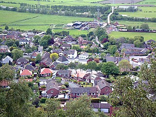
Helsby is a village, civil parish and electoral ward in the unitary authority of Cheshire West and Chester and the ceremonial county of Cheshire, England. Overlooking the Mersey estuary, it is approximately 9 miles (14 km) north east of Chester and 2.5 miles (4 km) south west of Frodsham.

Barrow is a civil parish, in the unitary authority of Cheshire West and Chester and the ceremonial county of Cheshire, England. The civil parish contains the village of Great Barrow and the hamlets of Little Barrow, Broomhill and Stamford Bridge. Great Barrow is situated about 4.5 miles east-north-east of Chester, 6 miles north-west of Tarporley and 6 miles south of Frodsham.

Tarporley is a large village and civil parish in Cheshire, England. The civil parish also contains the village of Rhuddall Heath. Tarporley is bypassed by the A49 and A51 roads.

Christleton is a village and civil parish on the outskirts of Chester, in the unitary authority of Cheshire West and Chester and the ceremonial county of Cheshire, England. The Shropshire Union Canal passes through the village.

Delamere is a village and former civil parish, now in the parish of Delamere and Oakmere, within the unitary authority area of Cheshire West and Chester, in the ceremonial county of Cheshire, England. It is approximately 7 miles (11 km) west of Northwich. The population of the civil parish taken at the 2011 census was 1,025. The name of the village comes from the French de la mer "of the sea". The civil parish was abolished on 1 April 2015 to form "Delamere and Oakmere"; parts also went to Kelsall, Utkinton and Cotebrook and Willington.

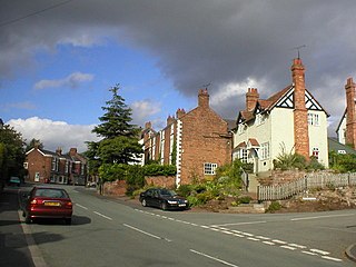
Willington is a village and civil parish 9 miles (14 km) from Chester in Cheshire, England. At the 2011 census, the population was 277.
Burton is a small village and former civil parish, now in the parish of Duddon and Burton, in the unitary authority of Cheshire West and Chester and the ceremonial county of Cheshire, England. In the 2001 census, the parish had a population of 50.

Peckforton is a scattered settlement and civil parish in the unitary authority of Cheshire East and the ceremonial county of Cheshire, England. The settlement is located 6.5 miles (10.5 km) to the north east of Malpas and 7.5 miles (12.1 km) to the west of Nantwich. The civil parish covers 1,754 acres (710 ha), with an estimated total population of 150 in 2006. The area is predominantly agricultural. Nearby villages include Bulkeley to the south, Beeston to the north, Higher Burwardsley to the west, Spurstow to the east and Bunbury to the north east.

Wardle is a village and civil parish in the unitary authority of Cheshire East and the ceremonial county of Cheshire, England. The village lies on the Shropshire Union Canal, north west of Barbridge Junction, and is 4 miles to the north west of Nantwich, and the parish also includes part of the small settlement of Wardle Bank. The total population is around 250. RAF Calveley was a flight-training station during the Second World War, and the Mark III radio telescope stood on the airfield site in 1966–96. The modern civil parish includes Wardle Industrial Estate and is otherwise largely agricultural. Nearby villages include Barbridge, Calveley and Haughton.

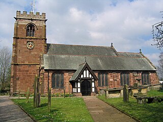
St Helen's Church is in the village of Tarporley, Cheshire, England. It is an active Anglican parish church in the diocese of Chester, the archdeaconry of Chester and the deanery of Malpas. Its benefice is united with those of St John and Holy Cross, Cotebrook, St Thomas, Eaton, and St Paul, Utkinton. The church is recorded in the National Heritage List for England as a designated Grade II* listed building.

Lower Kinnerton is a village and former civil parish, now in the parish of Dodleston, in the unitary authority of Cheshire West and Chester and the ceremonial county of Cheshire, England, close to the England–Wales border. The neighbouring village of Higher Kinnerton is across the border in Flintshire. Lower Kinnerton is south of Broughton and to the north west of the village of Dodleston. It is a small agricultural community, which is also home to a local kennel and cattery business.

Clutton is a village and civil parish in the unitary authority of Cheshire West and Chester and the ceremonial county of Cheshire, England. It lies nine miles from Wrexham and 11 miles from Chester. It had a population of 371 according to the 2011 census.

Hatton is a former civil parish, now in the parishes of Hargrave and Huxley, Golborne David and Tattenhall and District, in the unitary authority of Cheshire West and Chester and ceremonial county of Cheshire, England. The parish included most of the village of Hatton Heath, which is approximately 6 miles (9.7 km) south east of Chester and 4 miles (6.4 km) north-west of Tattenhall. The civil parish was abolished in 2015 and became part of Hargrave and Huxley, Golborne David and Tattenhall and District.

St John and the Holy Cross Church is in Stable Lane, Cotebrook, Cheshire, England. It is an active Anglican church in the parish of Tarporley, the deanery of Malpas, the archdeaconry of Chester, and the diocese of Chester. It is a daughter church of St Helen, Tarporley with St Thomas, Eaton. The church is recorded in the National Heritage List for England as a designated Grade II listed building.

St Thomas' Church is in Royal Lane, Eaton, Cheshire, England. It is an active Anglican parish church in the deanery of Malpas, the archdeaconry of Chester, and the diocese of Chester. Its benefice is united with those of St Helen, Tarporley, St John and Holy Cross, Cotebrook, and St Paul Utkinton. It is a small brick church built in 1896, with lancet windows, a west porch, and a timber bellcote. In 1936 the Lancaster architect Henry Paley of Austin and Paley refitted the church with a new marble floor to the sanctuary, reredos, pulpit, stalls, chancel screen, and with the creation of an organ chamber.
Utkinton is a former civil parish, now in the parishes of Utkinton and Cotebrook and Tarporley, in Cheshire West and Chester, England. It is entirely rural, and contains the villages of Utkinton and Cotebrook. The A49 road runs through it in a north–south direction. The parish contains 13 buildings that are recorded in the National Heritage List for England as designated listed buildings. One of these, Utkinton Hall, is listed at Grade I, and all the others are in Grade II. Other than the hall, some of the listed buildings are associated with the hall, and the others are domestic buildings, or related to farming. In Cotebrook, the church and its former parsonage are listed.