Auburndale, Massachusetts

Last updated

Auburndale, Massachusetts
Village
Auburndale Library, Auburndale MA.jpg
Auburndale Library
USA Massachusetts location map.svg
Red pog.svg
Auburndale
Usa edcp location map.svg
Red pog.svg
Auburndale
Coordinates: 42°20′50″N71°14′58″W / 42.34722°N 71.24944°W / 42.34722; -71.24944
Country United States
State Massachusetts
County Middlesex
City Newton
Time zone UTC-5 (Eastern (EST))
  Summer (DST) UTC-4 (EDT)
ZIP code
02466 [1]
Area code(s) 617 and 857

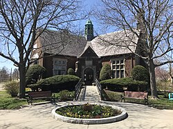
Auburndale is one of the thirteen villages within the city of Newton in Middlesex County, Massachusetts, United States. It lies at the western end of Newton near the intersection of interstate highways 90 and 95. It is bisected by the Massachusetts Turnpike (Interstate 90). Auburndale is surrounded by three other Newton villages (West Newton, Waban, and Newton Lower Falls) as well as the city of Waltham and the Charles River. Auburndale is the home of Williams and Burr elementary schools, as well as Lasell College. Auburndale Square is the location of the Plummer Memorial Library, which is run by the Auburndale Community Library and no longer affiliated with the Newton Free Library, the Turtle Lane Playhouse, and many small businesses.

Contents

History

The first major settler in the area was William Robinson who built a house in 1678 on what is now Freeman Street. The oldest house in Auburndale stands at 473 Auburn Street and was built in 1730 by William Robinson. [2]

Auburndale, once billed as Auburndale-on-the-Charles, was the home of Norumbega Park which closed in 1963. The park included rides, a zoo, and boating. The nationally famous big band venue Totem Pole Ballroom was associated with Norumbega Park and closed in 1964. [3] The area now contains over 80 acres of conservation land as well as access to the Charles River.

Transportation

Auburndale is divided into two parts by the Massachusetts Turnpike, which connects it to neighboring villages of Newton and downtown Boston. The village is located adjacent to the intersection of interstate highways 90 and 95.

A number of public transportation options connect Auburndale to neighboring communities. The MBTA Green Line's D Branch light rail line serves Auburndale at Woodland and Riverside stations, the latter being the line's terminus. Both stations have bus connections; Woodland station is served by MWRTA bus routes 1 and 8, while Riverside connects to MBTA bus route 558.

The MBTA Commuter Rail's Framingham/Worcester Line serves the village at Auburndale station, adjacent to the Massachusetts Turnpike. MBTA bus routes 505 and 558, which offer express service to downtown Boston, both stop at the station.

National Register historic sites

Nineteen places in Auburndale are on the National Register of Historic Places, as follows

ImageSite NameStreet addressBuilt/Founded/CommentsDate
designated
Auburndale Congregational Church-United Parish of Auburndale 64 Hancock St. ?October 4, 1986
Clark House 379 Central St. ?October 4, 1986
E. C. Hammond House 35 Groveland St. ?March 16, 1990
Harding House-Walker Missionary Home 161–163 Grove St. ?October 4, 1986
House at 203 Islington Road 203 Islington Rd. ?October 4, 1986
House at 102 Staniford Street 102 Staniford St. ?October 4, 1986
House at 2212 Commonwealth Avenue 2212 Commonwealth Ave. ?October 4, 1986
House at 230 Melrose Street 230 Melrose St. ?October 4, 1986
House at 307 Lexington Street 307 Lexington St. ?October 4, 1986
House at 31 Woodbine Street 31 Woodbine St. ?October 4, 1986
Lasell Neighborhood Historic District Roughly bounded by Woodland and Studio Rds., Aspen and Seminary Aves., and Grove St. Includes Lasell College. ?October 4, 1986
Old Shephard Farm 1832 Washington St., on city rolls as 39 Stanton Avenue ?October 4, 1986
Plummer Memorial Library 375 Auburn St. ?March 16, 1990
Riverside Concrete Company-Lamont's Market 2 Charles St. ?March 16, 1990
Rufus Estabrook House 33 Woodland Rd ?October 4, 1986
The Eminence 122 Islington Rd. ?October 4, 1986
Walker Home for Missionary Children 161–63, 165, 167 Grove St., 136, 138, 144 Hancock St. ?July 4, 1992
Whittemore's Tavern 473 Auburn St. ?October 4, 1986
Winslow-Haskell Mansion 53 Vista Ave. ?November 25, 1979

Local Historic District

Established in 2005, the Auburndale Historic District includes approximately 275 properties and encompasses two National Register Districts. [4] [5]

Places of worship

Points of interest

See also

Related Research Articles

<span class="mw-page-title-main">Newton, Massachusetts</span> City in Massachusetts, United States

Newton is a city in Middlesex County, Massachusetts, United States. It is approximately 7 miles (11 km) west of downtown Boston. Newton comprises a patchwork of thirteen villages without a city center. At the 2020 U.S. census, the population of Newton was 88,923.

<span class="mw-page-title-main">Weston, Massachusetts</span> Town in Massachusetts, United States

Weston is a town in Middlesex County, Massachusetts, about 15 miles west of Boston. At the time of the 2020 United States Census, the population of Weston was 11,851.

<span class="mw-page-title-main">Chestnut Hill, Massachusetts</span> Village in Massachusetts, United States

Chestnut Hill is a wealthy New England village located six miles (10 km) west of downtown Boston, Massachusetts, United States. Like all Massachusetts villages, Chestnut Hill is not an incorporated municipal entity. It is located partially in Brookline in Norfolk County; partially in the city of Boston in Suffolk County, and partially in the city of Newton in Middlesex County. Chestnut Hill's borders are defined by the 02467 ZIP Code. The name refers to several small hills that overlook the 135-acre Chestnut Hill Reservoir rather than one particular hill. Chestnut Hill is best known as the home of Boston College and as part of the Boston Marathon route.

<span class="mw-page-title-main">Riverside station (MBTA)</span> Light rail station in Newton, Massachusetts

Riverside is the western terminus of the MBTA Green Line D branch light rail line. It is located at 333 Grove Street, off Exit 38 on Interstate 95, in Auburndale, a village of Newton, Massachusetts. Riverside includes a parking lot with spaces for 925 automobiles and bicycle parking. West of the station is Riverside Yard, the main maintenance facility and largest storage yard for the Green Line. The station is fully accessible.

The Middlesex and Boston Street Railway (M&B) was a streetcar and later bus company in the area west of Boston. Streetcars last ran in 1930, and in 1972 the company's operations were merged into the Massachusetts Bay Transportation Authority (MBTA).

<span class="mw-page-title-main">Commonwealth Avenue (Boston)</span>

Commonwealth Avenue is a major street in the cities of Boston and Newton, Massachusetts. It begins at the western edge of the Boston Public Garden, and continues west through the neighborhoods of the Back Bay, Kenmore Square, Boston University, Allston, Brighton and Chestnut Hill. It continues as part of Route 30 through Newton until it crosses the Charles River at the border of the town of Weston.

<span class="mw-page-title-main">Newtonville, Massachusetts</span> Village in Newton, Massachusetts

Newtonville is one of the thirteen villages within the city of Newton in Middlesex County, Massachusetts, United States.

<span class="mw-page-title-main">Lasell University</span> Private university in Auburndale, Massachusetts, United States

Lasell University (LU) is a private university in Auburndale, Massachusetts. Lasell offers undergraduate and graduate degrees in the liberal arts, sciences, and professional fields of study.

<span class="mw-page-title-main">Woodland station</span> Light rail station in Newton, Massachusetts

Woodland station is a light rail stop on the MBTA Green Line D branch, located off Washington Street (MA-16) between the Newton Lower Falls and Auburndale villages of Newton, Massachusetts, United States. It serves as access to the Newton-Wellesley Hospital, as well as a park and ride station for nearby Route 128.

<span class="mw-page-title-main">United Parish of Auburndale</span> Historic church in Massachusetts, United States

United Parish of Auburndale, formerly the Auburndale Congregational Church, is a historic church at 64 Hancock Street in the Auburndale village of Newton, Massachusetts. Built in 1857 for an 1850 congregation and repeatedly enlarged, it is a prominent regional example of Romanesque architecture in wood. It was added to the National Register of Historic Places on September 4, 1986.

<span class="mw-page-title-main">Newtonville station</span>

Newtonville station is a commuter rail station on the MBTA Commuter Rail Framingham/Worcester Line, located between the Massachusetts Turnpike and Washington Street at Newtonville Square in the village of Newtonville in Newton, Massachusetts. Stairway entrances are located on the bridges over the Turnpike at Walnut Street and Harvard Street. Newtonville station is not accessible; renovations for accessibility are planned.

<span class="mw-page-title-main">West Newton station</span>

West Newton station is an MBTA Commuter Rail station in Newton, Massachusetts. It serves the Framingham/Worcester Line, and is located inside the Massachusetts Turnpike Exit 16 rotary in the village of West Newton. West Newton has had continuous rail service since 1834. The station consists of a single low side platform serving one of the line's two tracks, with small crossings to access trains on the far track. West Newton is not accessible; a renovation for accessibility is planned.

<span class="mw-page-title-main">Auburndale station (MBTA)</span>

Auburndale station is an MBTA Commuter Rail station in Auburndale, Massachusetts. It serves the Framingham/Worcester Line. It is located next to the Massachusetts Turnpike near Lasell College. The modern station platform, built around 1961, replaced a highly acclaimed 1881 depot building designed by H. H. Richardson. A full renovation of the station for accessibility is planned.

<span class="mw-page-title-main">Charles River Bike Path</span> Bicycle path in Boston, Massachusetts

The Charles River Bike Path is a mixed-use path in the Boston, Massachusetts area. It is named after the cardiologist Paul Dudley White, a prominent advocate of preventive medicine. His research led him to proclaim frequently "I'd like to put everybody on bicycles." In 1955 White served as president Eisenhower's cardiologist and prescribed his famous patient bicycle therapy after his 1955 heart attack.

<span class="mw-page-title-main">Harding House-Walker Missionary Home</span> Historic house in Massachusetts, United States

The Harding House-Walker Missionary Home is a historic house at 161–163 Grove Street in the Auburndale village of Newton, Massachusetts. The 2+12-story wood-frame house was built c. 1850, and is a well-preserved example of Italianate styling. It was built for Rev. Sewell Harding, a significant early speculator in Auburndale real estate. Harding sold the house in the 1860s; after serving as a dormitory for Lasell Junior College for several decades, it was acquired in 1925 by the Walker Home for Missionary Children, an organization established by Harding's daughter, Eliza Walker.

<span class="mw-page-title-main">Lasell Neighborhood Historic District</span> Historic district in Massachusetts, United States

The Lasell Neighborhood Historic District is a historic district roughly bounded by Woodland and Studio Roads, Aspen and Seminary Avenue, and Grove Street in Newton, Massachusetts village of Auburndale, Massachusetts. The area includes high-quality late-19th and early-20th century housing built in the area, and includes buildings on the campus of Lasell University, established as the Auburndale Female Seminary in 1851. The district was listed on the National Register of Historic Places in 1986.

<span class="mw-page-title-main">Upper Charles River Reservation</span> State park in Massachusetts, U.S.

The Upper Charles River Reservation is a Massachusetts state park encompassing portions of the banks of the Charles River between the Watertown Dam in Watertown and Riverdale Park in Dedham and the West Roxbury neighborhood of Boston. The park is managed by the Massachusetts Department of Conservation and Recreation. It includes land in the communities of Watertown, Waltham, Newton, Weston, Wellesley, Needham, Dedham, and Boston. Some of the Charles River Reservation Parkways also fall within the park boundaries. The Charles River Bike Path follows the river through much of the reservation.

<span class="mw-page-title-main">Newton Corner station</span> Boston MBTA former subway station

Newton Corner was a streetcar and passenger rail station in the Newton Corner neighborhood of Newton, Massachusetts, located near where Washington Street crosses the Massachusetts Turnpike. The Newton Corner station, known simply as Newton for much of its lifetime, served commuters on the Worcester Line from 1834 to 1959. The trolley stop, located on the surface streets, served a number of routes beginning in 1898, including the Green Line A branch until 1969.

References

  1. "Auburndale ZIP Code". zipdatamaps.com. 2022. Retrieved November 18, 2022.
  2. Historic Auburndale, published by the Auburndale Community Association (1996)
  3. Norumbega Park. Norumbega Park. Retrieved on 2011-04-09.
  4. Lasell Neighborhood Association (LNA) Archived 2008-09-05 at the Wayback Machine . Lasellneighborhood.org. Retrieved on 2011-04-09.
  5. City of Newton-Planning & Development. Newtonma.gov. Retrieved on 2011-04-09.
  6. Corpus Christi-St. Bernard Parish – Home. Ccsbparish.org. Retrieved on 2011-04-09.
  7. Church – Episcopal Parish of the Messiah Newton MA Auburndale an anglocatholic faith community. Parishofthemessiah.org (2011-03-22). Retrieved on 2011-04-09.
  8. Welcome to Temple Reyim, A Congregation of Friends. Reyim.org. Retrieved on 2011-04-09.
  9. United Parish of Auburndale Faith is about learning. Upanewtonma.org. Retrieved on 2011-04-09.
  10. City of Newton Archived July 22, 2009, at the Wayback Machine . Ci.newton.ma.us. Retrieved on 2011-04-09.
  11. Auburndale Park. Newton Conservators. Retrieved on 2011-04-09.
  12. Norumbega Park Conservation Area. Newton Conservators (2008-09-14). Retrieved on 2011-04-09.
  13. Turtle Lane Playhouse. Turtlelane.org. Retrieved on 2011-04-09.

Commons-logo.svg Media related to Auburndale, Massachusetts at Wikimedia Commons