Graniteville Historic District (Westford, Massachusetts)

Last updated

Graniteville Historic District
C.G. Sargent's Sons 1877, Graniteville, MA.jpg
C.G. Sargent's Sons 1877
USA Massachusetts location map.svg
Red pog.svg
Usa edcp location map.svg
Red pog.svg
Location Westford, Massachusetts
Coordinates 42°35′42″N71°28′12″W / 42.59500°N 71.47000°W / 42.59500; -71.47000
Area150 acres (61 ha)
ArchitectWoodcock, S.S.; et al.
Architectural styleFederal, Gothic
NRHP reference No. 01001467 [1]
Added to NRHPJanuary 17, 2002

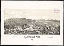
The Graniteville Historic District of Westford, Massachusetts, USA, encompasses one of the town's historic 19th century industrial villages. The area was, until the arrival of the railroad in 1847, primarily known for its granite quarries. The railroad's arrival prompted the construction of an industrial mill by Charles G. Sargent, and the area developed rapidly thereafter. A significant amount of housing stock, as well as civic institutional buildings, were built during the second half of the 19th century. The district is bounded on the east by River Street and on the south by Bridge Street and North Main Street. The western edge of the district runs just before North Main Street's junction with West Street, northward and then eastward to encompass a number of quarry sites, before meeting North Main Street at River Street. [2]

Lithograph of Graniteville from 1886 by L.R. Burleigh with list of landmarks Graniteville, Mass. (2674701324).jpg
Lithograph of Graniteville from 1886 by L.R. Burleigh with list of landmarks

The district was listed on the National Register of Historic Places in 2002. [1]

See also

Related Research Articles

<span class="mw-page-title-main">Orange Center Historic District (Orange, Massachusetts)</span> Historic district in Massachusetts, United States

Orange Center Historic District is a historic district encompassing the historic civic, commercial, and industrial heart of Orange, Massachusetts in the United States. It was listed on the National Register of Historic Places in 1989.

<span class="mw-page-title-main">Hotchkissville Historic District</span> Historic district in Connecticut, United States

The Hotchkissville Historic District is a historic district in the town of Woodbury, Connecticut, that was listed on the National Register of Historic Places in 1995. The district encompasses most of the historic village of Hotchkissville, which is centered at the junction of Washington and Weekeepeemee roads. The village began as a dispersed rural agricultural community, but developed in the 19th century with the arrival of industry, primarily the manufacture of textiles. Despite this, the village has retained a significantly rural character, and includes a broad cross-section of 18th- and 19th-century architectural styles.

<span class="mw-page-title-main">West Brookfield Center Historic District</span> Historic district in Massachusetts, United States

The West Brookfield Center Historic District is a historic district encompassing the historic center of West Brookfield, Massachusetts. When first listed on the National Register of Historic Places in 1990, it was centered on the triangular junction of Main Street, North Main Street, and School Street, extending away from this area along Main Street, North Main Street, and Foster Hill Road. A few of its properties lie on side streets adjacent to these roads. This area represented the core of Brookfield, before it was broken into smaller communities, including West Brookfield. It has a fine collection of 18th and 19th century homes, ranging stylistically from Federal to Queen Anne, as well as the town hall and public library.

<span class="mw-page-title-main">Baldwinville Village Historic District</span> Historic district in Massachusetts, United States

The Baldwinville Village Historic District encompasses the historic elements of the village of Baldwinville, a 19th-century mill village in northern Templeton, Massachusetts. Although its industrial elements have largely been lost, the district retains period housing and civic buildings. It was listed on the National Register of Historic Places in 1986.

<span class="mw-page-title-main">Millis Center Historic District</span> Historic district in Massachusetts, United States

The Millis Center Historic District is an historic district on Curve, Daniels, Exchange, Irving, Lavender, Main, and Union Streets in Millis, Massachusetts. It encompasses the historic mid-to-late-19th century village center of the town, including the residential area north of Main Street, two 19th-century industrial complexes, and civic and institutional buildings. It was added to the National Register of Historic Places in 2007.

<span class="mw-page-title-main">Farnams Village Historic District</span> Historic district in Massachusetts, United States

Farnams Village Historic District is a historic district in Cheshire, Massachusetts, United States. It encompasses the historic limestone mining community known as Farnams Village and the associated surviving industrial and mining infrastructure associated with a mining operation active from the late 19th century into the mid-20th century. The main village area is centered on Lanesborough Road in southern Cheshire, near Farnams and Quarry Roads, with quarry sites on the hillside to the west. The district was listed on the National Register of Historic Places in 2000.

<span class="mw-page-title-main">Mill River Historic District</span> Historic district in Massachusetts, United States

Mill River Historic District is a historic district encompassing the traditional center of government and a former industrial mill village along the Konkapot River in the village of Mill River in New Marlborough, Massachusetts. The district is roughly bounded by Main Street and River Church, Southfield, Clayton, School, and Hayes Hill Roads. It encompasses about 425 acres (172 ha), and contains mostly 19th century residential and civic buildings, as well as remnants of 19th century industrial activity.

<span class="mw-page-title-main">South Lee Historic District</span> Historic district in Massachusetts, United States

The South Lee Historic District encompasses the historic portion of the village of South Lee in Lee, Massachusetts. Extending mainly along Massachusetts Route 102 between Fairview Street and the Stockbridge town line, the village is a well-preserved 19th-century mill village, with fine Federal and Greek Revival buildings and a later 19th-century paper mill. It was listed on the National Register of Historic Places in 1999.

<span class="mw-page-title-main">Main Street Historic District (Greenfield, Massachusetts)</span> Historic district in Massachusetts, United States

The Main Street Historic District encompasses the civic core of Greenfield, Massachusetts, the county seat of Franklin County, Massachusetts. The district includes several blocks of Main Street extending roughly from Chapman Street in the west to Franklin Street in the east, as well as a number of properties facing the common along Bank Row, south of Main Street, and is architecture reflective of the city's 19th-century growth as a major crossroads and county seat. The district includes the town hall, county courthouse, several 19th century bank buildings, and three properties previously listed on the National Register of Historic Places: the Garden Theater Block, the Leavitt-Hovey House, and the 1915 Post Office building. The district was listed on the National Register of Historic Places in 1988.

<span class="mw-page-title-main">Cushman Village Historic District</span> Historic district in Massachusetts, United States

The Cushman Village Historic District is a historic district encompassing a portion of the Cushman Village area of Amherst, Massachusetts, which was a significant mill village during the 19th century. It is centered on the triangle formed by Bridge, Henry, and Pine Streets in northeastern Amherst, and arose because of the presence of falls on the Mill River, whose water power was harnessed for mills as early as the mid-18th century. Two houses survive from the colonial period. The village, although it was defined for many years by the mills, no longer has any industrial buildings, as they were demolished or destroyed by fire. Most of the houses in the district were built before 1860, the peak of the village's industrial activity. The district was listed on the National Register of Historic Places in 1992.

<span class="mw-page-title-main">East Village Historic District (Amherst, Massachusetts)</span> Historic district in Massachusetts, United States

The East Village Historic District is a historic district encompassing the center of the East Village of Amherst, Massachusetts, United States. It includes properties on Main Street, North East Street, and South East Street. The village was one of Amherst's principal civic and commercial centers until the arrival of the railroad in Amherst Center in 1853, and remained a primarily residential area thereafter. The district was listed on the National Register of Historic Places in 1986.

<span class="mw-page-title-main">Chester Factory Village Historic District</span> Historic district in Massachusetts, United States

The Chester Factory Village Historic District is a historic district encompassing the historic village of Chester Factories in Chester, Massachusetts. Chester was settled in the 1760s, and the factory village was a location where water power was harnessed at an early time for grist mills and sawmills. The village got its name from the Chester Glass Factory, which operated in the area through the War of 1812. It benefited from the construction of a turnpike leading to Chester Center in 1804, and was transformed by the arrival of the railroad around 1840. The village became an important provisioning stop for trains, and the village further benefited by the fact that the railroad bypassed Chester Center. The economic and civic life of the town gradually shifted, and Chester Factories is where the town hall and library were built. It was added to the National Register of Historic Places in 1989.

<span class="mw-page-title-main">Russell Center Historic District</span> Historic district in Massachusetts, United States

The Russell Center Historic District is a historic district encompassing the historic village center of Russell, Massachusetts. It is centered at the junction of Main Street and Lincoln Avenue, and is bordered by the Westfield River to the east, and the rising foothills of The Berkshires to the west. The village's 19th century development was spurred by the railroad and sustained by local papermaking businesses. It was listed on the National Register of Historic Places in 1996, and was named as one of the 1,000 places to visit in Massachusetts by the Great Places in Massachusetts Commission.

<span class="mw-page-title-main">Andover Village Industrial District</span> Historic district in Massachusetts, United States

The Andover Village Industrial District encompasses one of the 19th century industrial mill villages of Andover, Massachusetts known locally as "The Village". The growth of this village contributed to the decision in the 19th century to separate the more rural area of North Andover from the town. It is centered on a stretch of the Shawsheen River between North Main Street on the east and Moraine Street on the west. Most of the district's properties lie on Stevens Street, Red Spring Road, Shawsheen Road, and Essex Street, with a few properties also located on adjacent roads.

<span class="mw-page-title-main">Forge Village Historic District</span> Historic district in Massachusetts, United States

The Forge Village Historic District of Westford, Massachusetts encompasses one of the town's historic 19th century mill villages. The focal point of the district is the mill complex of the Abbot Worsted Company, around which the village expanded after its founding in 1854. Prior to its founding the area was the site of a number of blacksmithies and iron forging operations, and was the site of a fulling mill in the 18th century. The center of the district is at the junction of East and West Prescott Streets with Pleasant Street, radiating away to ballfields on West Prescott, Abbot Street at Pleasant, and just beyond Orchard Street on East Prescott. Worker housing occupies a number of adjacent streets in the area.

<span class="mw-page-title-main">East Jaffrey Historic District</span> Historic district in New Hampshire, United States

The East Jaffrey Historic District is a historic district running roughly along NH Route 124 through Jaffrey, New Hampshire. It encompasses what is now the economic and civic heart of the town, centered on the Jaffrey Mills and the crossing of the Contoocook River by Route 124. It extends as far west as St. Patrick's Church beyond Charlonne Street and as far east as the US Post Office building at Route 124 and Ellison Street. To the north it extends along Peterborough Street to Christian Court, and to the south it extends along River Street and School Street to their junction. The district includes early 19th-century residential structures, as well as industrial buildings and housing associated with the Jaffrey Mills which arose in the mid-19th century. The district was added to the National Register of Historic Places in 2002.

<span class="mw-page-title-main">Suncook Village Commercial–Civic Historic District</span> Historic district in New Hampshire, United States

The Suncook Village Commercial–Civic Historic District encompasses the civic and commercial heart of Suncook, New Hampshire, a village on the Suncook River in Pembroke and Allenstown. The civic district is a 3-acre (1.2 ha) area on the Pembroke side of the river, adjacent to the Pembroke Mill, a site that had seen industrial use since the 18th century. The district includes 21 commercial buildings, 19 of which are historically significant. The district was listed on the National Register of Historic Places in 2005.

<span class="mw-page-title-main">Fair Haven Green Historic District</span> Historic district in Vermont, United States

The Fair Haven Green Historic District encompasses the village green of Fair Haven, Vermont, and the heterogeneous collection of civic, commercial, and residential buildings that line it and adjacent streets. The area was developed mainly following the arrival of the railroad in 1848 and the subsequent expansion of marble and slate quarries in the area. The district was listed on the National Register of Historic Places in 1980.

<span class="mw-page-title-main">Bethel Village Historic District</span> Historic district in Vermont, United States

The Bethel Village Historic District encompasses the historic core of the village of Bethel in the town of Bethel, Vermont, USA. The L-shaped district extends along Main and Church Streets, including many of the village's commercial and civic buildings, as well as a significant number of 19th and early 20th-century residences. The district was listed on the National Register of Historic Places in 1976, and was slightly enlarged in 1990.

<span class="mw-page-title-main">Morrisville Historic District (Morristown, Vermont)</span> Historic district in Vermont, United States

The Morrisville Historic District encompasses most of the historic commercial downtown area of the village of Morrisville in Morristown, Vermont. Developed in the early 19th century as a service town for the surrounding agricultural areas, it was transformed into a major service regional commercial center by the arrive of the railroad in 1872. Its surviving architecture is largely reflective of these two time periods. It was listed on the National Register of Historic Places in 1983, and enlarged in 2007.

References

  1. 1 2 "National Register Information System". National Register of Historic Places . National Park Service. April 15, 2008.
  2. "NRHP nomination for Graniteville Historic District". Commonwealth of Massachusetts. Retrieved April 4, 2014.