Hopkinton (CDP), Massachusetts

Last updated

Hopkinton, Massachusetts
Hopkinton Supply Company Building, MA.jpg
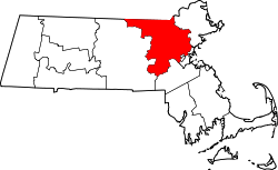
Middlesex County Massachusetts incorporated and unincorporated areas Hopkinton (CDP) highlighted.svg
Location in Middlesex County in Massachusetts
Coordinates: 42°13′42″N71°31′19″W / 42.22833°N 71.52194°W / 42.22833; -71.52194
Country United States
State Massachusetts
County Middlesex
Town Hopkinton
Area
[1]
  Total1.535 sq mi (3.98 km2)
  Land1.532 sq mi (3.97 km2)
  Water0.003 sq mi (0.008 km2)
Elevation
442.6 ft (134.9 m)
Population
 (2020) [2]
  Total2,651
  Density1,730.4/sq mi (668.1/km2)
Time zone UTC-5 (Eastern (EST))
  Summer (DST) UTC-4 (EDT)
ZIP Code
01748
Area code 978
FIPS code 25-31050
GNIS feature ID2378144

Hopkinton is a census-designated place (CDP) comprising the central village in the town of Hopkinton, Middlesex County, Massachusetts, United States. The population of the CDP was 2,651 at the 2020 census, [2] out of 18,758 in the entire town.

Contents

Geography

Hopkinton village is located in southwestern Middlesex County, at the center of the town of Hopkinton. Massachusetts Route 135 passes through the community as Main Street, leading northeastward 6 miles (10 km) to Framingham and northwest the same distance to Westborough. Massachusetts Route 85 runs through the village as Cedar Street and Grove Street, leading north 5 miles (8 km) to Southborough and south 6 miles (10 km) to Milford. Interstate 495 passes 1 mile (1.6 km) west of the village, with access from Route 30. I-495 leads north 9 miles (14 km) to Marlborough and southeast 12 miles (19 km) to Franklin.

According to the U.S. Census Bureau, the Hopkinton CDP has a total area of 1.54 square miles (3.99 km2), of which 0.003 square miles (0.008 km2), or 0.20%, are water. [1] The village sits on a hill which drains north toward Indian Brook and east toward Cold Spring Brook, both tributaries of the Sudbury River, part of the Concord River watershed leading north to the Merrimack River.

Demographics

Historical population
CensusPop.Note
1950 1,829
1960 2,75450.6%
1970 1,956−29.0%
1980 2,54230.0%
1990 2,305−9.3%
2000 2,62814.0%
2010 2,550−3.0%
2020 2,6514.0%
U.S. Decennial Census [3]

As of the census of 2020, there were 2,651 people, 1,002 households, and 662 families residing in the CDP. The population density was 1,730.4 inhabitants per square mile (668.1/km2). There were 1,058 housing units, 56 of which were recorded as vacant. [4] The racial makeup of the CDP was 84.31% White, 1.32% Black or African American, 0.08% Native American, 5.36% Asian, 0.11% Pacific Islander, 1.92% some other race, and 6.90% from two or more races. Hispanic or Latino of any race were 5.09% of the population. [2]

Of the 1,002 households in the CDP, 35.0% had children under the age of 18 living with them, 54.5% were married couples living together, 25.6% were a female householder with no spouse or partner present, and 15.2% were a male householder with no spouse or partner present. 25.2% of all households were made up of individuals, and 12.0% were someone living alone who was 65 years of age or older. The average household size was 2.50, and the average family size was 3.27. [5]

In the CDP 21.1% of the population were under the age of 18, 7.7% were from 18 to 24, 20.5% from 25 to 44, 29.8% from 45 to 64, and 20.7% were 65 years of age or older. For every 100 females, there were 91.1 males. For every 100 females age 18 and over, there were 89.8 males. [5]

As of the period 2017–2021, the median income for a household in the CDP was $149,677, and the median income for a family was over $250,000. The per capita income for the CDP was $99,714. About 2.4% of the population were below the poverty line, including 0.8% of those under age 18 and 10.8% of those age 65 or over. [6]

Related Research Articles

<span class="mw-page-title-main">Covelo, California</span> Census-designated place in California, United States

Covelo is a census-designated place (CDP) in Mendocino County, California, United States. Covelo is located 14 miles (23 km) east-northeast of Laytonville, at an elevation of 1,398 feet (426 m). The population was 1,394 at the 2020 census, up from 1,255 at the 2010 census. 405 acres (1.64 km2) of Covelo is part of the Round Valley Indian Reservation.

<span class="mw-page-title-main">Progress Village, Florida</span> Census-designated place in Florida, United States

Progress Village is a census-designated place (CDP) in Hillsborough County, Florida, United States. Per the 2020 census, the population was 11,188.

<span class="mw-page-title-main">North Fort Myers, Florida</span> Census-designated place in Florida, United States

North Fort Myers is an unincorporated area and census-designated place (CDP) in Lee County, Florida, United States. It is part of the Cape Coral-Fort Myers, Florida Metropolitan Statistical Area. The population was 42,719 at the 2020 census.

<span class="mw-page-title-main">Homestead Base, Florida</span> Census-designated place in Florida

Homestead Base is a census-designated place (CDP) in Miami-Dade County, Florida, United States. The CDP comprises the extent of Homestead Air Reserve Base plus some surrounding land. It is part of the Miami metropolitan area of South Florida. The population was 999 at the 2020 census.

<span class="mw-page-title-main">Ives Estates, Florida</span> Census-designated place in Florida

Ives Estates is a census-designated place (CDP) in Miami-Dade County, Florida. It is part of the Miami metropolitan area of South Florida. The population was 25,005 at the 2020 census, up from 19,525 in 2010.

<span class="mw-page-title-main">Princeton, Florida</span> Census-designated place in Florida

Princeton is a census-designated place (CDP) and unincorporated community in Miami-Dade County, Florida, United States. It is part of the Miami metropolitan area of South Florida. The population was 39,208 at the 2020 census, up from 22,038 at the 2010 census.

<span class="mw-page-title-main">Richmond West, Florida</span> Census-designated place in Florida

Richmond West is a census-designated place (CDP) in Miami-Dade County, Florida, United States. It is part of the Miami metropolitan area of South Florida. The population was 35,884 at the 2020 census, up from 31,973 at the 2010 census.

<span class="mw-page-title-main">The Crossings, Florida</span> CDP in Florida

The Crossings is a census-designated place (CDP) and suburb of Miami in Miami-Dade County, Florida, United States. It is part of the Miami metropolitan area of South Florida. The CDP includes the neighborhoods of The Crossings, Devon Aire, and Calusa. The population was 23,276 at the 2020 census.

<span class="mw-page-title-main">Three Lakes, Florida</span> Census-designated place in Florida

Three Lakes is a census-designated place (CDP) and planned community in Miami-Dade County, Florida, United States. It is part of the Miami metropolitan area of South Florida. The population was 16,540 at the 2020 census, up from 15,047 in 2010.

<span class="mw-page-title-main">West Perrine, Florida</span> Census-designated place in Florida

West Perrine is a census-designated place (CDP) in Miami-Dade County, Florida, United States. It is part of the Miami metropolitan area of South Florida. The population was 10,602 at the 2020 census, up from 9,460 in 2010.

<span class="mw-page-title-main">Westview, Florida</span> Census-designated place in Florida

Westview is a census-designated place (CDP) in Miami-Dade County, Florida, United States. It is part of the Miami metropolitan area of South Florida. The population was 9,923 at the 2020 census.

<span class="mw-page-title-main">Duck Key, Florida</span> Census-designated place in Florida, United States

Duck Key is a census-designated place and unincorporated community in Monroe County, Florida, United States, on an island of the same name in the middle Florida Keys. The CDP also includes the neighboring island of Conch Key. As of the 2020 census, the CDP had a population of 727, up from 621 in 2010.

<span class="mw-page-title-main">Tavernier, Florida</span> Census-designated place in Florida, United States

Tavernier is a census-designated place (CDP) and unincorporated community in Monroe County, Florida, United States on Key Largo, the largest island in the upper Florida Keys. Tavernier's population was 2,530 at the 2020 census, up from 2,136 in 2010.

Fox Lake Hills is an unincorporated community and census-designated place (CDP) in Lake Villa Township, Lake County, Illinois, United States. Per the 2020 census, the population was 2,684.

Gages Lake is a census-designated place (CDP) in Warren Township, Lake County, Illinois, United States. The population was 10,637 at the 2020 census.

<span class="mw-page-title-main">Contoocook, New Hampshire</span> Census-designated place in New Hampshire, United States

Contoocook is a village and census-designated place (CDP) within the town of Hopkinton in Merrimack County, New Hampshire, United States. The population was 1,427 at the 2020 census. Contoocook is well known for its growth of small businesses, preservation of historical landmarks, community involvement and recreational activities within the village.

<span class="mw-page-title-main">Castle Point, Missouri</span> Place in Missouri, United States

Castle Point is an unincorporated community and census-designated place (CDP) in St. Louis County, Missouri, United States. The population was 3,962 at the 2010 census.

<span class="mw-page-title-main">Antrim (CDP), New Hampshire</span> Census-designated place in New Hampshire, United States

Antrim is a census-designated place (CDP) and the main village in the town of Antrim in Hillsborough County, New Hampshire, United States. The population of the CDP was 1,395 at the 2020 census, out of 2,651 in the entire town.

<span class="mw-page-title-main">Groton (CDP), Massachusetts</span> Census-designated place in Massachusetts, United States

Groton is a census-designated place (CDP) comprising the main village in the town of Groton in Middlesex County, Massachusetts, United States. The population of the CDP was 1,353 at the 2020 census, out of 11,315 in the entire town of Groton.

<span class="mw-page-title-main">Pepperell (CDP), Massachusetts</span> Census-designated place in Massachusetts, United States

Pepperell is a census-designated place (CDP) comprising the main village in the town of Pepperell in Middlesex County, Massachusetts, United States. The population was 2,390 at the 2020 census, out of 11,604 in the entire town of Pepperell.

References

  1. 1 2 "2022 U.S. Gazetteer Files: Massachusetts". United States Census Bureau. Retrieved June 19, 2023.
  2. 1 2 3 "P1. Race – Hopkinton CDP, Massachusetts: 2020 DEC Redistricting Data (PL 94-171)". U.S. Census Bureau. Retrieved June 19, 2023.
  3. "Census of Population and Housing". Census.gov. Retrieved June 4, 2016.
  4. "H1. Occupancy Status – Hopkinton CDP, Massachusetts: 2020 DEC Redistricting Data (PL 94-171)". U.S. Census Bureau. Retrieved June 19, 2023.
  5. 1 2 "DP1. Profile of General Population and Housing Characteristics – Hopkinton CDP, Massachusetts: 2020 DEC Demographic Profile Data (PL 94-171)". U.S. Census Bureau. Retrieved June 19, 2023.
  6. "DP03. Selected Economic Characteristics – Hopkinton CDP, Massachusetts: 2021 ACS 5-Year Estimates Data Profiles (PL 94-171)". U.S. Census Bureau. Retrieved June 19, 2023.