Mission Hills, Los Angeles

Last updated
Mission Hills
Fountain Mission San Fernando.jpg
Location map San Fernando Valley.png
Red pog.svg
Mission Hills
Location within Los Angeles/San Fernando Valley
U.S. - Los Angeles Metropolitan Area location map.svg
Red pog.svg
Mission Hills
Mission Hills (the Los Angeles metropolitan area)
Coordinates: 34°15′26″N118°28′02″W / 34.25722°N 118.46722°W / 34.25722; -118.46722
Country United States
State California
County Los Angeles
City Los Angeles
Named for Mission San Fernando Rey de España
Elevation
913 ft (278 m)
Population
 (2000) [1]
  Total15,056
Time zone UTC−8 (PST)
  Summer (DST) UTC−7 (PDT)
ZIP Code
91345
Area code(s) 747 and 818

Mission Hills is a neighborhood in the City of Los Angeles, California, located in the San Fernando Valley.

Contents

It is near the northern junction of the Golden State Freeway (I-5) and the San Diego Freeway (I-405). The Ronald Reagan Freeway (SR-118) bisects the community. Mission Hills is at the northern end of the long Sepulveda Boulevard. Other main thoroughfares are San Fernando Mission Boulevard, Woodman Avenue, and Rinaldi, Brand, Chatsworth, Devonshire, and Lassen Streets. The boundaries are roughly Sepulveda Blvd and Interstate 405 to the west, Interstate 5 to the north and east, Van Nuys Boulevard to the southeast, and Lassen Street to the south. The Granada Hills community lies to the west, Sylmar to the north, the city of San Fernando to the northeast, Pacoima to the east, Arleta to the southeast, and Panorama City to the south.

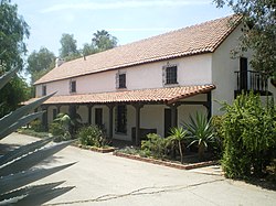
The historical town was Hickson, now is named Mission Hills for the nearby Spanish Mission San Fernando Rey de España (1784). It includes the Andrés Pico Adobe, the second oldest residence still standing in Los Angeles. The San Fernando Mission Cemetery, located a short distance away, is one of the oldest active cemeteries within the San Fernando Valley.

Demographics

The historic Romulo Pico Adobe, built in 1834 by the prominent Pico family of California, is the oldest residence in San Fernando Valley. Romulo Pico Adobe, MIssion Hills.JPG
The historic Rómulo Pico Adobe, built in 1834 by the prominent Pico family of California, is the oldest residence in San Fernando Valley.

The 2010 U.S. census counted 18,496 residents in the area's 91345 ZIP Code. The median age was 36.3, and the median yearly household income at that time was $62,426. [2]

In 2009, the Los Angeles Times 's "Mapping L.A." project supplied the following numbers for the community of Mission Hills. Population: 18,237; median household income: $75,675. [3]

Education

Residents are zoned to schools in the Los Angeles Unified School District. Mission Hills has one private school within its boundaries; Bishop Alemany High School which is run by the Archdiocese of Los Angeles.[ citation needed ]

Medical centers

The community is serviced by Providence Holy Cross Medical Center, Facey Medical Group, and a newly opened Kaiser Permanente. [4]

Government and infrastructure

Postal services

The United States Postal Service operates the Mission City Post Office at 10919 Sepulveda Boulevard. [5] [6]

Health services

The Los Angeles County Department of Health Services operates the Pacoima Health Center in Pacoima, serving Mission Hills. [7]

Police

In May 2005, the Los Angeles Police Mission Area was established as the 19th station built in the City of Los Angeles. This police station serves the communities of Mission Hills, Sylmar, North Hills, Arleta, and Panorama City.

Fire & EMS

The City of Los Angeles Fire Department provides fire and emergency medical services from Station 75. This consists of two engines (E75 & E275), a ladder truck (T75), and both an advanced life support ambulance (Rescue 75) and a basic life support ambulance (Rescue 875).

Federal representation

State representation

Mission Hills is located within California's 39th State Assembly district represented by Democrat Luz Rivas and California's 18th State Senate district represented by Democrat Robert Hertzberg. [10]

Local representation

Mission Hills is located within Los Angeles City Council District 7 represented by Monica Rodriguez. [11]

Economy

Tourism

Tourists visit the Mission San Fernando Rey de España, a historical mission. The Andrés Pico Adobe is the second-oldest adobe home in the city of Los Angeles. [12]

Notable natives

Ryan Braun Ryan Braun.jpg
Ryan Braun

People who were born in Mission Hills include:

Related Research Articles

<span class="mw-page-title-main">Northridge, Los Angeles</span> Neighborhood in California, US

Northridge is a neighborhood in the San Fernando Valley region of the City of Los Angeles. The community is home to California State University, Northridge, and the Northridge Fashion Center.

<span class="mw-page-title-main">Van Nuys</span> Neighborhood of Los Angeles in California, United States

Van Nuys is a neighborhood in the central San Fernando Valley region of Los Angeles, California. Home to Van Nuys Airport and the Valley Municipal Building, it is the most populous neighborhood in the San Fernando Valley.

<span class="mw-page-title-main">San Fernando, California</span> City in California, United States

San Fernando is a general-law city in the San Fernando Valley region of Los Angeles County, California, in the Los Angeles metropolitan area. It is an enclave in the City of Los Angeles. As of the 2020 census the population of San Fernando was 23,946.

<span class="mw-page-title-main">San Fernando Valley</span> Valley in Los Angeles County, California, US

The San Fernando Valley, known locally as the Valley, is an urbanized valley in Los Angeles County, California. Situated to the north of the Los Angeles Basin, it contains a large portion of the city of Los Angeles, as well as several unincorporated areas; and the incorporated cities of Burbank, Calabasas, Glendale, Hidden Hills, and San Fernando. The valley is well known for its film studios such as Warner Bros. Studios and Walt Disney Studios. In addition, it is home to the Universal Studios Hollywood theme park.

<span class="mw-page-title-main">Arleta, Los Angeles</span> Neighborhood of Los Angeles in California, United States

Arleta is a neighborhood in the San Fernando Valley region of the city of Los Angeles, California, with a high percentage of Latino residents and of people born outside the United States.

<span class="mw-page-title-main">Sylmar, Los Angeles</span> Suburban neighborhood of Los Angeles, California

Sylmar is a suburban neighborhood in the San Fernando Valley and is the northernmost neighborhood within the city of Los Angeles. Historically known for its profusion of sylvan olive orchards, Sylmar can trace its past to the 18th century and the founding of the San Fernando Mission. In 1890, olive production was begun systematically. The Sylmar climate was also considered healthy, and so a sanitarium was established, the first in a series of hospitals in the neighborhood. There are fourteen public and eight private schools within Sylmar.

<span class="mw-page-title-main">Pacoima, Los Angeles</span> Neighborhood of Los Angeles in California, United States

Pacoima is a neighborhood in Los Angeles, California. Pacoima is one of the oldest neighborhoods in the San Fernando Valley region of LA.

Panorama City is a neighborhood in the city of Los Angeles, California, in the San Fernando Valley. It has a generally young age range as well as the highest population density in the Valley. More than half of the neighborhood's population was born abroad, the majority being from Mexico. Known as the Valley's first planned community after a transition from agriculture to a post-World War II housing boom, it has been home to several notable residents. It is now a mixture of single-family homes and low-rise apartment buildings.

<span class="mw-page-title-main">Granada Hills, Los Angeles</span> Neighborhood of Los Angeles

Granada Hills is a neighborhood in the San Fernando Valley region of Los Angeles. The community has a sports program and a range of city recreation centers. The neighborhood has fourteen public and ten private schools.

North Hills, known previously as Sepulveda, is a neighborhood in the San Fernando Valley region of Los Angeles, California.

<span class="mw-page-title-main">Sepulveda Boulevard</span> Street in Los Angeles, California

Sepulveda Boulevard is a major street and transportation corridor in the City of Los Angeles and several other cities in western Los Angeles County, California. The street parallels Interstate 405 for much of its route. Portions of Sepulveda Boulevard between Manhattan Beach and Los Angeles International Airport (LAX) are designated as part of State Route 1.

<span class="mw-page-title-main">Laurel Canyon Boulevard</span>

Laurel Canyon Boulevard is a major street in the city of Los Angeles. It starts off at Polk Street in Sylmar in the northern San Fernando Valley near the junction of the San Diego and the Golden State (I-5)) freeways. Laurel Canyon Boulevard bypasses the city of San Fernando to the west, running parallel to I-5 in the vicinity of Pacoima and Arleta. The portion through Sun Valley passes through rock quarries and a great deal of open space.

<span class="mw-page-title-main">California's 29th congressional district</span> U.S. House district for California

California's 29th congressional district is a congressional district in the U.S. state of California based in the north central San Fernando Valley. The district is represented by Democrat Tony Cárdenas.

San Fernando High School (SFHS) is a high school of the Los Angeles Unified School District. It is located in the Pacoima neighborhood of Los Angeles, in the northeastern San Fernando Valley, California. It is near and also serves the City of San Fernando.

Van Nuys Boulevard is a major north-south arterial road that runs through the central San Fernando Valley of Los Angeles County, California. The boulevard was notable for its cruising lifestyle that was prevalent in the 1960s and 1970s, which was depicted in the 1979 film Van Nuys Blvd.

<span class="mw-page-title-main">California's 20th senatorial district</span> American legislative district

California's 20th State Senatorial district is one of 40 California State Senate districts. It is currently represented by Democrat Caroline Menjivar of Panorama City.

<span class="mw-page-title-main">Pacoima Wash</span> River in the United States

Pacoima Wash, 33 miles (53 km) long, is a major tributary of the Tujunga Wash, itself a tributary of the Los Angeles River, in the San Fernando Valley of Los Angeles County, California.

<span class="mw-page-title-main">Los Angeles's 1st City Council district</span> American legislative district

Los Angeles's 1st City Council district is one of the fifteen districts in the Los Angeles City Council. It is currently represented by Democrat Eunisses Hernandez since 2022, after she beat previous councilmember Gil Cedillo that year.

<span class="mw-page-title-main">Glenoaks Boulevard</span> Thoroughfare in Los Angeles County, California

Glenoaks Boulevard is a major thoroughfare in Los Angeles County, which stretches some 22.4 miles as a north-south thoroughfare in Sylmar at its intersection with Foothill Boulevard to a west-east thoroughfare in Glendale before ending in the Scholl Canyon area as a minor street. It passes through much of the San Fernando Valley including San Fernando, Pacoima, and Sun Valley. It is also a north-south thoroughfare in Burbank. Glenoaks Boulevard runs east of and parallel to Interstate 5 in San Fernando and Burbank, and north of and parallel to State Route 134 in Glendale.

<span class="mw-page-title-main">Los Angeles's 7th City Council district</span> American legislative district

Los Angeles's 7th City Council district is one of the fifteen districts in the Los Angeles City Council. It is currently represented by Democrat Monica Rodriguez since 2017 after winning an election to succeed Felipe Fuentes, who resigned the year prior.

References

  1. "Los Angeles Almanac: City of Los Angeles Population by Community & Race 2000 Census". Archived from the original on January 11, 2010. Retrieved November 28, 2008.
  2. "Community Facts" American FactFinder, United States Census Bureau
  3. "Mission Hills". Mapping L.A.
  4. "Facey". Archived from the original on 2013-03-02. Retrieved 2013-05-18.
  5. "Post Office Location – MISSION HILLS." United States Postal Service . Retrieved on December 6, 2008.
  6. "Post Office Location – MISSION CITY." United States Postal Service . Retrieved on December 6, 2008.
  7. "Pacoima Health Center." Los Angeles County Department of Health Services. Retrieved on March 17, 2010.
  8. California Senators accessed February 11, 2021
  9. https://ziplook.house.gov/htbin/findrep_house[Mission Hills - 91345]
  10. http://findyourrep.legislature.ca.gov [Mission Hills,CA 91345]
  11. http://navigatela.lacity.org/common/mapgallery/pdf/council_districts/CDindex_8.5_11.pdf%7Ctitle=Map%5B%5D of LA City Council Districts
  12. "Historic | City of Los Angeles Department of Recreation and Parks". www.laparks.org. 13 October 2021.

34°15′26″N118°28′02″W / 34.257222°N 118.467222°W / 34.257222; -118.467222