Valley Glen, Los Angeles

Last updated
Valley Glen
Valley Glen Neighborhood Signage.jpg
Valley Glen neighborhood sign
located at the intersection of Burbank Boulevard
and Fulton Avenue
Location map San Fernando Valley.png
Red pog.svg
Valley Glen
Location within Los Angeles
Coordinates: 34°09′54″N118°23′47″W / 34.16488°N 118.3965°W / 34.16488; -118.3965
Country Flag of the United States.svg  United States of America
State Flag of California.svg  California
County Flag of Los Angeles County, California.svg Los Angeles
Time zone Pacific
Zip Code
91401, 91405, 91601
Area code(s) 747, 818
Website greatervalleyglencouncil.org

Valley Glen is a neighborhood in the southeastern section of the San Fernando Valley in Los Angeles, California. Once part of Van Nuys and North Hollywood, it became a separate neighborhood in 1998. Valley Glen is home to Los Angeles Valley College and the Great Wall of Los Angeles, a half-mile-long California-history mural listed on the National Register of Historic Places.

Contents

History

Prior to 1998, Valley Glen was part of Van Nuys and North Hollywood. In 1997, more than 70% of the area’s homeowners signed a petition to change the name of a section of Van Nuys (between Burbank and Victory boulevards) to Valley Glen. The proposed Valley Glen neighborhood would encompass 1,200 homes. [1]

In February 1998, some adjacent neighborhoods joined Valley Glen and City Councilman Mike Feuer endorsed the name change. Valley Glen became an official Los Angeles neighborhood in June 1998. The new neighborhood encompassed more than 3,000 homes between Hazeltine and Whitsett Avenues. [2]

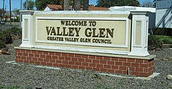
In 1998, the Department of Transportation installed 12 neighborhood signs. [2] In 2004, CalTrans agreed to erect a sign on the Hollywood (170) Freeway identifying the location of Valley Glen. [3] In 2008, the US Postal Service officially recognized the neighborhood by designating all or part of 91401 (Van Nuys), 91405 (Van Nuys) and 91606 (North Hollywood) to be Valley Glen. [4] In 2013, the city approved the installation of a monument sign proposed by the Greater Valley Glen Council. It is located at the intersection of Burbank Boulevard and Coldwater Canyon Avenue. [5]

Geography

Valley Glen map from the Los Angeles Times Geographical boundaries of Valley Glen neighborhood, Los Angeles, California.png
Valley Glen map from the Los Angeles Times

In the "Mapping L.A." geographical section of the Los Angeles Times website, the 4.81 square miles of Valley Glen are bounded on the north by Raymer Street, Sherman Way or Vanowen Street, on the west by the Tujunga Wash, Woodman Avenue or Hazeltine Avenue, on the south by Burbank Boulevard and on the east by the Hollywood Freeway. In most of its area it is bisected by the Tujunga Wash, which runs north to south. [6]

Population

In 2000, Valley Glen had a population of 59,230, according to the U.S. Census, and by 2008 its population was 62,846, according to the Los Angeles Department of City Planning.

Ethnically, Valley Glen is "highly diverse," with Latinos at 45.2%, whites at 39.5%, Asians at 5.4%, blacks at 3.9% and others at 6%. It is also high within the city for the percentage of foreign born (49%), with Mexico (26.9%) and Armenia (14.4%) being the most common foreign places of birth. In other respects — population density, income, university education, age, homeowners, military service, it is "about average" for the city of Los Angeles. [6] Twenty-one percent of Valley Glen residents aged 25 and older had earned a four-year degree by 2000, an average figure for both the city and the county. [6] [7]

Valley Glen monument at the intersection of Burbank Boulevard and Coldwater Canyon Avenue. Valley Glen Monument.jpg
Valley Glen monument at the intersection of Burbank Boulevard and Coldwater Canyon Avenue.

Arts and culture

The Great Wall of Los Angeles , a half mile-long mural portraying the history of California "as seen through the eyes of women and minorities," stretches along the concrete sides of the Tujunga Wash, and is credited with being one of the longest murals in the world. It was nominated for the National Register of Historic Places on May 10, 2017. [8] [9]

Emergency services

Fire service

Los Angeles Fire Department operates Station 102 (South Van Nuys/Valley Glen), serving the community.

Police service

The Los Angeles Police Department operates the nearby Van Nuys Community Police Station located at 6420 Sylmar Avenue, 91401, which serves the neighborhood. [10]

Parks and recreation

Education

Los Angeles Valley College LAVC marquee.jpg
Los Angeles Valley College

Valley Glen is home to Los Angeles Valley College.

Schools within the Valley View boundaries are: [12]

Public

Ulysses S. Grant High School GrantHSLA.JPG
Ulysses S. Grant High School

Related Research Articles

<span class="mw-page-title-main">Van Nuys</span> Neighborhood of Los Angeles in California, United States

Van Nuys is a neighborhood in the central San Fernando Valley region of Los Angeles, California. Home to Van Nuys Airport and the Valley Municipal Building, it is the most populous neighborhood in the San Fernando Valley.

<span class="mw-page-title-main">San Fernando Valley</span> Valley in Los Angeles County, California, US

The San Fernando Valley, known locally as the Valley, is an urbanized valley in Los Angeles County, California. Situated to the north of the Los Angeles Basin, it contains a large portion of the City of Los Angeles, as well as unincorporated areas and the incorporated cities of Burbank, Calabasas, Glendale, Hidden Hills, and San Fernando. The valley is well known for its iconic film studios such as Warner Bros. Studios and Walt Disney Studios. In addition, it is home to the Universal Studios Hollywood theme park.

<span class="mw-page-title-main">Reseda, Los Angeles</span> Neighborhood of Los Angeles in California, United States

Reseda is a neighborhood in the San Fernando Valley region of Los Angeles, California. It was founded in 1912, and its central business district started developing in 1915. The neighborhood was devoted to agriculture for many years. Earthquakes struck the area in 1971 and 1994.

<span class="mw-page-title-main">Sherman Oaks, Los Angeles</span> Neighborhood of Los Angeles in California, United States

Sherman Oaks is a neighborhood in the city of Los Angeles, California located in the San Fernando Valley, founded in 1927. The neighborhood includes a portion of the Santa Monica Mountains, which gives Sherman Oaks a lower population density than some other areas in Los Angeles.

<span class="mw-page-title-main">North Hollywood, Los Angeles</span> Neighborhood in Los Angeles, California, United States of America

North Hollywood is a Los Angeles, California neighborhood, located in the San Fernando Valley. The neighborhood contains the NoHo Arts District, the El Portal Theatre, several art galleries, and the Academy of TV Arts and Sciences. The North Hollywood Metro Rail station is one of the few subway-accessible Metro Rail stations in Los Angeles.

<span class="mw-page-title-main">Pacoima, Los Angeles</span> Neighborhood of Los Angeles in California, United States

Pacoima is a neighborhood in Los Angeles, California. Pacoima is one of the oldest neighborhoods in the San Fernando Valley region of LA.

Panorama City is a neighborhood in the city of Los Angeles, California, in the San Fernando Valley. It has a generally young age range as well as the highest population density in the Valley. More than half of the neighborhood's population was born abroad, the majority being from Mexico. Known as the Valley's first planned community after a transition from agriculture to a post-World War II housing boom, it has been home to several notable residents. It is now a mixture of single-family homes and low-rise apartment buildings.

<span class="mw-page-title-main">Sun Valley, Los Angeles</span> Neighborhood of Los Angeles in California, United States

Sun Valley is a neighborhood in Los Angeles, California in the San Fernando Valley region. The neighborhood is known for its overall youthful population and moderate racial diversity. There are three recreation centers in Sun Valley, one of which is a historic site. The neighborhood has thirteen public schools—including John H. Francis Polytechnic High School and Valley Oaks Center for Enriched Studies (VOCES)—and four private schools.

<span class="mw-page-title-main">Valley Village, Los Angeles</span> Neighborhood in Los Angeles, California, United States

Valley Village is a neighborhood in the city of Los Angeles, located within the San Fernando Valley.

<span class="mw-page-title-main">Lake Balboa, Los Angeles</span> Neighborhood of Los Angeles in California, United States

Lake Balboa is a neighborhood in the San Fernando Valley region of Los Angeles, California. The area was previously part of Van Nuys.

Shadow Hills is a neighborhood in the Verdugo Mountains and northeastern San Fernando Valley, within the city of Los Angeles, California.

<span class="mw-page-title-main">California's 29th congressional district</span> U.S. House district for California

California's 29th congressional district is a congressional district in the U.S. state of California based in the north central San Fernando Valley. The district is represented by Democrat Tony Cárdenas.

Victory Boulevard is a major east–west arterial road that runs for 25 miles (40 km) traversing the entire length of the San Fernando Valley in Los Angeles County, Southern California, United States.

Van Nuys Boulevard is a major north-south arterial road that runs through the central San Fernando Valley of Los Angeles County, California. The boulevard was notable for its cruising lifestyle that was prevalent in the 1960s and 1970s, which was depicted in the 1979 film Van Nuys Blvd.

<span class="mw-page-title-main">Pacoima Wash</span> River in the United States

Pacoima Wash, 33 miles (53 km) long, is a major tributary of the Tujunga Wash, itself a tributary of the Los Angeles River, in the San Fernando Valley of Los Angeles County, California.

<span class="mw-page-title-main">Los Angeles's 2nd City Council district</span> American legislative district

Los Angeles's 2nd City Council district is one of the fifteen districts in the Los Angeles City Council. It is currently represented by Democrat Paul Krekorian since 2009, after he won the special election to finish Wendy Greuel's term.

<span class="mw-page-title-main">Sunland-Tujunga, Los Angeles</span> Neighborhood of Los Angeles in California, United States

Sunland-Tujunga is a Los Angeles city neighborhood within the Crescenta Valley and Verdugo Mountains. Sunland and Tujunga began as separate settlements and today are linked through a single police station, branch library, neighborhood council, chamber of commerce, city council district, and high school. The merging of these communities under a hyphenated name goes back as far as 1928. Sunland-Tujunga contains the highest point of the city, Mount Lukens.

<span class="mw-page-title-main">Coldwater Canyon Avenue</span> Street in Los Angeles County, California, US

Coldwater Canyon Avenue is a street, primarily within the City of Los Angeles, in Los Angeles County, California. It runs 10.3 miles (16.6 km) from North Beverly Drive at Coldwater Canyon Park in Beverly Hills, north up Coldwater Canyon, including a short stretch shared with Mulholland Drive, ending at a crossroad intersection with Roscoe Boulevard in Sun Valley, where the Coldwater Canyon Avenue changes into Sheldon Street.

<span class="mw-page-title-main">Tujunga Wash Greenway</span> Cycling route in California, USA

The Tujunga Wash Greenway and Bike Path is a trail and stormwater mitigation project in the Valley Village and Valley Glen neighborhoods of California’s San Fernando Valley.

References

  1. Becker, Tom (December 31, 1997). "Residents Will Discuss Creating 'Valley Glen'". Los Angeles Times. Retrieved 24 February 2021.
  2. 1 2 Baker, Michael (June 25, 1998). "Community Signs Now Mark the Spot". Los Angeles Times. Retrieved 24 February 2021.
  3. "RATIFYING THE DESIGNATION OF VALLEY GLEN AS A DISTINCT COMMUNITY" (PDF). February 6, 2004. Retrieved 24 February 2021.
  4. Behrens, Zach (September 11, 2008). "Chipping Away at Van Nuys: Valley Glen Snags Zip Codes". LAist.com. Retrieved 24 February 2021.
  5. "Council File No. 13-0026" (PDF). January 28, 2013. Retrieved 24 February 2021.
  6. 1 2 3 "Valley Glen," Mapping L.A., Los Angeles Times
  7. "Less Than High School," Mapping L.A., Los Angeles Times
  8. "2017 Actions Taken". Office of Historic Preservation. 2017. Retrieved 24 February 2021.
  9. "National Register of Historic Places; Notification of Pending Nominations and Related Actions". National Archives. September 2017. Retrieved 24 February 2021.
  10. LAPD Online
  11. "Valley Glen Community Park." City of Los Angeles. Retrieved on March 19, 2010.
  12. "Valley Glen: Schools," Mapping L.A., Los Angeles Times