Granada Hills, Los Angeles

Last updated

Granada Hills
Granada Hills CA 2010.jpg
A welcome sign at Chatsworth Street and Zelzah Avenue
Motto: 
"The Valley's Most Neighborly Town" [1]
Granada Hills, California, map.jpg
Boundaries of Granada Hills as drawn by the Los Angeles Times
Location map San Fernando Valley.png
Red pog.svg
Granada Hills
Location within Los Angeles/San Fernando Valley
U.S. - Los Angeles Metropolitan Area location map.svg
Red pog.svg
Granada Hills
Granada Hills (the Los Angeles metropolitan area)
Coordinates: 34°17′N118°30′W / 34.283°N 118.500°W / 34.283; -118.500
Named for Spanish word for "pomegranate"
Area
  Total15.11 sq mi (39.1 km2)
Elevation
959 ft (292 m)
Population
 (2008)
  Total53,998
  Density3,574/sq mi (1,380/km2)
Time zone UTC−8 (PST)
  Summer (DST) UTC−7 (PDT)
Area code 818

Granada Hills is a neighborhood in the San Fernando Valley region of Los Angeles. The community has a sports program and a range of city recreation centers. The neighborhood has fourteen public and ten private schools.

Contents

History

The Granada Hills area is situated on the traditional homelands of the Tongva and Chumash. [2] The Tongva village of Ceegenga may have been the closest village located to the Granada Hills area. [3]

The community began as a dairy farm and orchard known as the Sunshine Ranch which grew apricots, oranges, walnuts and beans. Vestiges of former citrus groves can still be seen in orange, lemon or grapefruit trees in many residential yards. In 1916, the San Fernando Valley's first oil well was drilled in what is now Granada Hills. The oil well was located at the northern tip of Zelzah Avenue. Granada Hills was founded in 1926 as "Granada;" the "Hills" portion of the name was added 15 years later. [4]

Geography and climate

Granada Hills is located at the foothills of the Santa Susana Mountains, north of North Hills, Northridge, west of Mission Hills and Sylmar, and east of the Porter Ranch neighborhoods of Los Angeles. The Ronald Reagan Freeway (State Route 118) runs through its southern area. Van Norman Reservoir, the southern terminus of the Los Angeles Aqueduct, is located in Granada Hills.

Climate data for Granada Hills, Los Angeles
MonthJanFebMarAprMayJunJulAugSepOctNovDecYear
Mean daily maximum °F (°C)66
(19)
68
(20)
70
(21)
75
(24)
78
(26)
85
(29)
92
(33)
93
(34)
88
(31)
81
(27)
72
(22)
66
(19)
78
(26)
Mean daily minimum °F (°C)43
(6)
44
(7)
45
(7)
47
(8)
51
(11)
55
(13)
58
(14)
60
(16)
57
(14)
52
(11)
46
(8)
43
(6)
50
(10)
Average precipitation inches (mm)4.14
(105)
4.39
(112)
3.81
(97)
0.90
(23)
0.22
(5.6)
0.06
(1.5)
0.02
(0.51)
0.15
(3.8)
0.35
(8.9)
0.51
(13)
1.52
(39)
2.24
(57)
18.31
(465)
Source: [5]

Demographics

The 2000 U.S. census counted 50,535 residents in the 15.11-square-mile neighborhood—or 3,344 people per square mile. In 2008, the city estimated that the population had increased to 53,998, a density of 3,574 people per square mile. In 2000 the median age for residents was 37. [6]

The neighborhood is ethnically diverse and includes whites, 55.5%; Latinos, 20.6%; Asians, 16.3%; blacks, 3.4%; and others, 4.2%. Korea (16.0%) and Mexico (13.8%) were the most common places of birth for 29.2% of the residents who were born abroad. [6]

The median yearly household income in 2008 was $83,911. Renters occupied 26.4% of the housing stock. The average household size of 2.9 people was considered average for Los Angeles. The percentages of married men (60.4%) and women (58.5%) were among the county's highest. There were 4,032 veterans, or 10.5% of the population, a high proportion compared to the rest of the city. [6]

Arts and culture

Architecture

One of the Eichler Homes Eichler Homes - Foster Residence, Granada Hills.jpg
One of the Eichler Homes

Granada Hills is composed mostly of Mid-century modern architecture. Of note is the "Balboa Highlands" tract built by iconic developer Joseph Eichler as well as the Knollwood Country Club area and Knollwood Grove tract. [2] Many of these homes, which are North of Rinaldi/West of Balboa, have been featured in movies, commercials, magazine pictorials and appear in books about Eichler or mid-century architecture.

Historical landmarks

Deodar trees on White Oak Ave. Cedrus deodara along White Oak Ave at Tribune St in Granada Hills 2014.jpg
Deodar trees on White Oak Ave.

White Oak Avenue, between San Fernando Mission and San Jose Street, was declared a Los Angeles Historic-Cultural Monument on August 3, 1966, for the 101 Deodar Cedar trees that line the street. The trees are native to the Himalayas and appreciated for their size, beauty and timber. White Oak Avenue trees were used as the back-drop in the flying bicycle scenes in the 1982 film E.T. the Extra-Terrestrial . [7]

Sports

Granada Hills Charter High School's stadium, the John Elway Stadium (named after the quarterback, an alumnus), is home to the Los Angeles Rampage women's soccer team and formerly home to the San Fernando Valley Quakes. [8]

In 1963, the Granada Hills Little League won the Little League World Championship in baseball. [9]

Parks and recreation

O'Melveny Park, the second largest park in Los Angeles, consists of a large undeveloped area and a much smaller developed section with several dozen citrus trees, a small intermittent stream, and grass and picnic areas. This 672-acre (2.72 km2) park includes hiking trails and fire roads, including a grassy promontory from which a view of the northeastern portion of the San Fernando Valley may be seen. [10] [11] Mission Point and its environs are popular mountain biking and hiking areas. The view from the top of Mission Point (called "Mission Peak" by many residents), the highest point in Granada Hills, is striking, taking in most of the San Fernando Valley. In clear weather, one can see the Pacific Ocean and Downtown Los Angeles. The area around the peak is home to deer, golden eagle, bobcats, mountain lions, raccoons, and coyotes. [12] [13]

The Granada Hills Recreation Center (also known as Petit Park) features an auditorium, baseball diamonds, basketball courts, children's play areas, a gym, picnic tables, tennis courts, classrooms, a dance room and a library. Programs are offered in sports, and arts and crafts. [14]

Zelzah Park, an unstaffed park, has a bridle path, a children's play area, and picnic tables. [15]

Government

Local

City Council

Los Angeles City Council District 12 encompasses Granada Hills, with councilmember John Lee serving.

Neighborhood Councils

Granada Hills is served by two Neighborhood Councils:

County, state and federal

Granada Hills is in California's 27th congressional district as of 2023 and represented by Republican Mike Garcia. [18] It was in the 38th State Assembly district, and the 20th State Senate district until the 2014 redistricting. [19]

Education

Thirty-two percent of Granada Hills residents aged 25 and older have earned a four-year degree by 2000, an average percentage for the city. [6]

Schools

Granada Hills Charter High School Granada-Hills-Charter-High-School.jpg
Granada Hills Charter High School
John F. Kennedy High School Kennedy High School (Los Angeles).jpg
John F. Kennedy High School

Schools within the Granada Hills boundaries are: [20]

Public

  • John F. Kennedy High School, 11254 Gothic Avenue
  • Granada Hills Charter High School (formerly Granada Hills High School), 10535 Zelzah Avenue
  • Jane Addams High School (continuation high school), 16341 Donmetz Street
  • North Valley Charter Academy, 16651-A Rinaldi Street
  • Valley Academy of Arts and Sciences, 10445 Balboa Boulevard
  • George K. Porter Middle School, 15960 Kingsbury Street
  • Robert Frost Middle School, 12314 Bradford Place
  • Patrick Henry Middle School, 17340 San Jose Street
  • El Oro Way Elementary Charter School, 12230 El Oro Way
  • Knollwood Elementary School, 11822 Gerald Avenue
  • Danube Avenue Elementary School, 11220 Danube Avenue
  • Tulsa Street Elementary School, 10900 Hayvenhurst Avenue
  • Haskell Elementary School, 15850 Tulsa Street
  • Van Gogh Street Elementary School, 17160 Van Gogh Street
  • Granada Elementary Community Charter School, 17170 Tribune Street
  • Rinaldi Adult Center (Adult School), 17540 Rinaldi Street #6 [21]

Private

  • St. Euphrasia School, Elementary, 17637 Mayerling Street
  • Jewish Educational Trade School, 16601 Rinaldi Street
  • Concordia Schools, preschool–8th grade, 16603 San Fernando Mission Boulevard
  • Granada Hills Baptist Elementary School, 10949 Zelzah Avenue
  • De La Salle Elementary School, 16535 Chatsworth Street
  • Abraham Joshua Heschel Day School (elementary), 17701 Devonshire Street
  • Pinecrest/Northridge School (elementary), 17081 Devonshire Street
  • Heritage Christian School (formerly Hillcrest) Christian School, 17531 Rinaldi Street (K–8), 10949 Zelzah Street (Preschool)
  • Heritage Christian School (formerly Los Angeles Baptist High School), 9825 Woodley Ave.
  • Iqra Elementary School, 11439 Encino Ave, Granada Hills, CA 91344 (preschool–7th)

Infrastructure

Public services

Los Angeles Fire Department Stations 18 (Knollwood/Granada Hills) and 87 (Granada Hills) are in the area.

Granada Hills is served by the Los Angeles Police Department Devonshire Community Police Station. [22]

Health care

The Los Angeles County Department of Health Services operates the Pacoima Health Center in Pacoima, serving Granada Hills. [23]

Postal service

The United States Postal Service Granada Hills Post Office is located at 18039 Chatsworth Street. [24]

Libraries

The Los Angeles Public Library operates the Granada Hills Branch and is located at 10640 Petit Avenue.

Notable people

Ryan Braun Rbraunmil2014.jpg
Ryan Braun
John Elway Uso-show-john-elway-defenselink-mil.jpg
John Elway

See also

Related Research Articles

<span class="mw-page-title-main">Northridge, Los Angeles</span> Neighborhood in California, US

Northridge is a neighborhood in the San Fernando Valley region of the City of Los Angeles. The community is home to California State University, Northridge, and the Northridge Fashion Center.

<span class="mw-page-title-main">San Fernando, California</span> City in California, United States

San Fernando is a general-law city in the San Fernando Valley region of Los Angeles County, California, in the Los Angeles metropolitan area. It is an enclave in the City of Los Angeles. As of the 2020 census the population of San Fernando was 23,946.

<span class="mw-page-title-main">Mission Hills, Los Angeles</span> Neighborhood of Los Angeles in California, United States

Mission Hills is a neighborhood in the City of Los Angeles, California, located in the San Fernando Valley.

<span class="mw-page-title-main">Canoga Park, Los Angeles</span> Neighborhood of Los Angeles

Canoga Park is a neighborhood in the San Fernando Valley region of the City of Los Angeles, California. Before the Mexican–American War, the district was part of a rancho, and after the American victory it was converted into wheat farms and then subdivided, with part of it named Owensmouth as a town founded in 1912. It joined Los Angeles in 1917 and was renamed Canoga Park on March 1, 1931, after Canoga, New York.

<span class="mw-page-title-main">San Fernando Valley</span> Valley in Los Angeles County, California, US

The San Fernando Valley, known locally as the Valley, is an urbanized valley in Los Angeles County, California. Situated to the north of the Los Angeles Basin, it contains a large portion of the city of Los Angeles, as well as several unincorporated areas; and the incorporated cities of Burbank, Calabasas, Glendale, Hidden Hills, and San Fernando. The valley is well known for its film studios such as Warner Bros. Studios and Walt Disney Studios. In addition, it is home to the Universal Studios Hollywood theme park.

<span class="mw-page-title-main">Chatsworth, Los Angeles</span> Neighborhood of Los Angeles in California, United States

Chatsworth is a suburban neighborhood in Los Angeles, California, in the San Fernando Valley.

<span class="mw-page-title-main">Reseda, Los Angeles</span> Neighborhood of Los Angeles in California, United States

Reseda is a neighborhood in the San Fernando Valley region of Los Angeles, California. It was founded in 1912, and its central business district started developing in 1915. The neighborhood was devoted to agriculture for many years. Earthquakes struck the area in 1971 and 1994.

<span class="mw-page-title-main">Arleta, Los Angeles</span> Neighborhood of Los Angeles in California, United States

Arleta is a neighborhood in the San Fernando Valley region of the city of Los Angeles, California, with a high percentage of Latino residents and of people born outside the United States.

<span class="mw-page-title-main">Winnetka, Los Angeles</span> Neighborhood of Los Angeles in California, United States

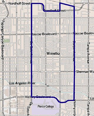
Winnetka is a neighborhood in the west-central San Fernando Valley in the city of Los Angeles. It is a highly ethnically diverse area, both for the city and for Los Angeles County, with a relatively large percentage of Hispanic and Asian people.

<span class="mw-page-title-main">Encino, Los Angeles</span> Neighborhood of Los Angeles in California, United States

Encino is a neighborhood in the San Fernando Valley region of Los Angeles, California.

<span class="mw-page-title-main">Sylmar, Los Angeles</span> Suburban neighborhood of Los Angeles, California

Sylmar is a suburban neighborhood in the San Fernando Valley and is the northernmost neighborhood within the city of Los Angeles. Historically known for its profusion of sylvan olive orchards, Sylmar can trace its past to the 18th century and the founding of the San Fernando Mission. In 1890, olive production was begun systematically. The Sylmar climate was also considered healthy, and so a sanitarium was established, the first in a series of hospitals in the neighborhood. There are fourteen public and eight private schools within Sylmar.

<span class="mw-page-title-main">Pacoima, Los Angeles</span> Neighborhood of Los Angeles in California, United States

Pacoima is a neighborhood in Los Angeles, California. Pacoima is one of the oldest neighborhoods in the San Fernando Valley region of LA.

<span class="mw-page-title-main">Sun Valley, Los Angeles</span> Neighborhood of Los Angeles in California, United States

Sun Valley is a neighborhood in Los Angeles, California in the San Fernando Valley region. The neighborhood is known for its overall youthful population and moderate racial diversity. There are three recreation centers in Sun Valley, one of which is a historic site. The neighborhood has thirteen public schools—including John H. Francis Polytechnic High School and Valley Oaks Center for Enriched Studies (VOCES)—and four private schools.

<span class="mw-page-title-main">West Hills, Los Angeles</span> Neighborhood in Los Angeles, California, United States

West Hills is an affluent residential community in the western San Fernando Valley region of the City of Los Angeles, California. The percentage of residents aged 35 and older is among the highest in Los Angeles County.

North Hills, known previously as Sepulveda, is a neighborhood in the San Fernando Valley region of Los Angeles, California.

Porter Ranch is a suburban-type neighborhood of the City of Los Angeles in the northwest portion of the San Fernando Valley.

<span class="mw-page-title-main">Lake Balboa, Los Angeles</span> Neighborhood of Los Angeles in California, United States

Lake Balboa is a neighborhood in the San Fernando Valley region of Los Angeles, California. The area was previously part of Van Nuys.

<span class="mw-page-title-main">Pacoima Wash</span> River in the United States

Pacoima Wash, 33 miles (53 km) long, is a major tributary of the Tujunga Wash, itself a tributary of the Los Angeles River, in the San Fernando Valley of Los Angeles County, California.

<span class="mw-page-title-main">Los Angeles's 7th City Council district</span> American legislative district

Los Angeles's 7th City Council district is one of the fifteen districts in the Los Angeles City Council. It is currently represented by Democrat Monica Rodriguez since 2017 after winning an election to succeed Felipe Fuentes, who resigned the year prior.

References

  1. "Granada Hills Chamber of Commerce". Granada Hills Chamber of Commerce. Retrieved September 6, 2012.
  2. 1 2 "Balboa Highlands – An Eichler Neighborhood – Historic Preservation Overlay Zone in Granada Hills, CA". balboahighlands.com.
  3. "Villages | TONGVA PEOPLE" . Retrieved April 21, 2023.
  4. Hier, Jim (July 18, 2007). Granada Hills. Images of America. Arcadia Publishing. ISBN   9780738547718.
  5. "Zipcode 91344". plantmaps.com. Retrieved March 23, 2021.
  6. 1 2 3 4 "Granada Hills", Mapping L.A., Los Angeles Times
  7. "No. 41 - 114 Deodar Trees". Big Orange Landmarks. July 4, 2007. Retrieved August 3, 2014.
  8. "√ Granada Hills Ciwidey Promo Free SHM Kavling Villa Wisata" (in Indonesian). November 27, 2018. Retrieved September 12, 2023.
  9. "Little League Baseball: Past Champions". Littleleague.org. Archived from the original on October 17, 2007. Retrieved January 25, 2011.
  10. "The Quiet Majesty of O'Melveny Park". The Trust for Public Land. Archived from the original on October 19, 2007.
  11. "O'Melveny Park". Santa Monica Mountains Conservancy. Archived from the original on April 5, 2018.{{cite web}}: CS1 maint: unfit URL (link)
  12. "Mission Point: Mission Point Trail". Trails.com. Retrieved July 24, 2010.
  13. "Neon Way – Granada Hills – Los Angeles County". socalmtb.com. Retrieved July 24, 2010.
  14. "Granada Hills Recreation Center a.k.a. Petit Park". City of Los Angeles Department of Recreation and Parks. Retrieved July 24, 2010.
  15. "Zelzah Park". City of Los Angeles Department of Recreation and Parks. Retrieved July 24, 2010.
  16. Granada Hills North Neighborhood Council
  17. Granada Hills South Neighborhood Council
  18. "California's 27th Congressional District - Representatives & District Map - GovTrack.us" . Retrieved December 12, 2023.
  19. "Project Vote Smart information for 91344". Votesmart.org. Retrieved January 25, 2011.
  20. "Granada Hills: Schools", Mapping L.A., Los Angeles Times
  21. "School Profile". www.nvoc.org.
  22. "Citywide Division Map". Los Angeles Police Department . Retrieved March 7, 2010.
  23. "Pacoima Health Center." Los Angeles County Department of Health Services. Retrieved on March 17, 2010.
  24. "Post Office Location – GRANADA HILLS." United States Postal Service . Retrieved on December 6, 2008.
  25. "Official Orders Dump to Make Changes but Won't Close It". Los Angeles Times. September 2, 1988.
  26. Mulhern, Tom, "Brewers: Braun's start a smashing success", Wisconsin State Journal, July 21, 2007
  27. Elling, Steve, "FOOTBALL : 49ers' Bregel Gives Money to Hospital, USC and Old Neighborhood, "Los Angeles Times", July 24, 1987
  28. "Chao-Li Chi obituary". Los Angeles Times . October 24, 2010.
  29. Reilly, Rick (May 10, 1983). "Elway's 'just one of the boys'". Eugene Register-Guard. (Denver Post). p. 1C.
  30. Cuba Gooding Jr at IMDb
  31. Eisenhammer, Fred, "NBA Finds It Hard to Get Gray Out", "Los Angeles Times", January 7, 1990.
  32. "Maurice Greene". Archived from the original on January 21, 2011. Retrieved January 21, 2011.
  33. Ashley Judd at IMDb
  34. "Michaele Pride, Architect, and Educator". African American Registry (AAREG).
  35. Farmer, Sam (June 16, 2011). "Jim Rodnunsky dies at 54; developer of Cablecam system used in sporting events, Hollywood films". Variety . Retrieved July 5, 2011.
  36. "Cablecam developer Jim Rodnunsky dies". Variety . June 16, 2011.
  37. "C.J. Sanders". UND.com. Retrieved July 29, 2016.
  38. "Biography of Frank Wilcox". Internet Movie Database . Retrieved February 17, 2013.
  39. Flamer, Keith. "Calling All Athletes: Granada Hills Lists An $11.6 Million Mansion Made For a Pro". Forbes.