Aliso Canyon | |
---|---|
The canyon viewed from the south, looking towards Temple Hill | |
Length | 6.5 mi (10.5 km) |
Width | 1.5 mi (2.4 km) |
Area | 13 sq mi (34 km2) |
Depth | 800 ft (240 m) |
Geography | |
Coordinates | 33°30′38″N117°45′11″W / 33.5106°N 117.753°W |
[1] |
Aliso Canyon is a 6.5-mile (10.5 km) canyon located in Orange County, California in the United States. The canyon is a water gap across the San Joaquin Hills carved out by Aliso Creek, possibly as recently as the last ice age. Located in a semi-arid climate, it supports a variety of plant communities – mainly chaparral and coastal sage scrub – and native animals, some endangered.
The canyon's northern divide once formed a formidable boundary between the indigenous Acjachemen and Tongva. Many Acjachemen archaeological sites have been found in the canyon. The fertile alluvial soil and grasslands of Aliso Canyon was used for orchards and grazing from Spanish conquest of the region until the early 20th century. Since the 1970s, the canyon has been the centerpiece of Aliso and Wood Canyons Wilderness Park.
Aliso Canyon has also suffered environmental damage in recent years. Upstream urban development since the 1950s has increased urban runoff into Aliso Creek, causing severe erosion throughout the valley floor. Pollution has also harmed the area's riparian zones. There have been plans to fix these problems, mainly by constructing drop structures to control erosion.
Aliso Canyon is a massive gap through the south-central part of the San Joaquin Hills. The San Joaquin Hills are a small coastal mountain range in Orange County, about 20 miles (32 km) long and 5 miles (8.0 km) wide. The Aliso Canyon is about 6.5 miles (10.5 km) long measured from where it begins near Laguna Niguel Regional Park to its outlet at Laguna Beach. About 800 feet (240 m) deep on average and 1.5 miles (2.4 km) wide at its widest extent, it is one of the largest gaps through the San Joaquin Hills. Others include the Laguna Canyon and the San Juan Creek canyon.
The valley has three distinct sections: the first, upstream one is a broad and comparatively shallow stretch 400 feet (120 m) deep and 1.3 miles (2.1 km) wide; the end of this section is marked by a small summit to the south. The second longest stretch is 1.5 miles (2.4 km) wide, 800 to 900 feet (240 to 270 m) deep, and about 4.5 miles (7.2 km) long, stretching from the Wood Canyon Creek confluence to a wastewater treatment plant near the outlet to the Pacific Ocean. The last section of the canyon is a narrow, steep gorge 0.8 miles (1.3 km) wide, 700 feet (210 m) deep and about 1 mile (1.6 km) long. Most of the valley floor is a deep fill of alluvium that is up to 300 feet (91 m) thick in the deepest portions. From the valley floor, steep hills rise abruptly to the canyon rim in less than 0.4 miles (0.64 km). These hills are dissected by many steep and short side canyons.
The major branch of Aliso Canyon is Wood Canyon, a 2.8-mile (4.5 km)-long, 600-to-800-foot (180 to 240 m)-deep gorge that runs generally southward to join Aliso Canyon about 5 miles (8.0 km) upstream of the ocean. Wood Canyon Creek drains Wood Canyon and joins Aliso Creek 1.5 miles (2.4 km) downstream of the beginning of the canyon. Cities bounding the canyon are Laguna Beach to the south and west, Laguna Niguel to the east, and Aliso Viejo to the northeast.
Despite its size, Aliso Canyon likely formed as recently as the Wisconsinian glaciation of the last glacial period, a length of time lasting from 60,000–10,000 years ago. During this time the San Joaquin Hills began to rise to their present-day form. (The uplift had actually begun as early as 1.22 million years ago, but the previous mountains had been eroded.) The Wisconsinian glaciation caused a shift in the entire climate of North America, pushing the cold, rainy climate of the Pacific Northwest south into California. The difference in sea level caused by the Wisconsinian glaciation was likely around -400 feet (120 m) from the previous sea level, in the Sangamonian Satge, which was also about 100 feet (30 m) higher than the present-day sea level. [2]
The new rainy climate of Southern California received around 80 inches (2,000 mm) of rain each year, which caused the rivers and streams to become powerful and with enormous erosive force. Aliso Creek cut a V-shaped river valley through the San Joaquin Hills over this time span. Near the end of the Wisconsinian, the canyon was already a 1,100-foot (340 m)-deep gorge with a narrow, powerful watercourse at the bottom; the valley floor was likely around 300 feet (91 m) wide. [3] When the Wisconsinian era ended, the glaciers melted and sea levels rose 300 feet (91 m) or so to their present level. Water backed up into Aliso Canyon and Wood Canyons, turning them into salt-water inlets. Over time, the creeks deposited enough sediment to fill the inlets with alluvium and create the present-day valley floor. This is the reason why the canyon resembles an aged U-shaped glacial valley instead of a relatively young V-shaped river valley. [2]
Historically, the Aliso Canyon floor was occupied by wide and braided Aliso Creek, which changed course often and flowed in a wide and shallow channel. Although the creek through the canyon remains unchannelized, it has suffered a series of effects from increasing runoff and pollution. Upstream development which has resulted in increased runoff with little sediment content has caused the creek to incise a 20-foot (6.1 m)-deep, 50-to-100-foot (15 to 30 m)-wide channel through the entire length of the valley. The creek now is continuing to incise through the soft alluvial soil and a community of exotic giant reed has established itself throughout the length of the valley.
There are two roads through Aliso Canyon, following opposite sides of the creek. One is the paved Aliso Creek trail and one is an unpaved private road that leads to a wastewater treatment plant near the mouth of the canyon, owned by the South Orange Water Conservation Agency (SOCWA). There is one dam and one weir across the creek as it flows through the valley. One is approximately 5.3 miles (8.5 km) upstream from the ocean, and is about 100 feet (30 m) long and 15 feet (4.6 m) high. [4] The weir is located just upstream of the mouth and is about 9 feet (2.7 m) long and 1 foot (0.3 m) high. There are also many drop structures on Wood Canyon Creek and there is a sewer line that follows most of the length of the canyon.
Except for some private development at the mouth of the canyon, the entire Aliso Canyon is mostly undeveloped. This private development consists of a hotel and golf course that also has a stretch of channelized creek. This section of canyon, the steepest and narrowest part, is also vulnerable to flooding during wet years. [5]
The Aliso Canyon has four major vegetation zones; these are riparian, chaparral, coastal sage scrub and grassland. Historically, there were salt marshes at the mouth of Aliso Creek, which sustained a large population of tidewater goby. These marshes, however, have now been eradicated by the construction of a sewage treatment plant at the mouth. Oak and sycamore trees make up the primary large plants along Wood Canyon Creek, and alder (which gave the canyon its name), live oak and other plants line Aliso Creek. Most of the rest of the valley floor, stretching from the edge of the riparian zone to the beginning of the hillside, is grassland. The side canyons and slopes are divided among chaparral and coastal sage scrub. Some non-native plants have begun to establish themselves from the fringes of residential areas on the bordering ridges. [6]
Bobcats, mountain lions, lynx and coyotes are some of the large mammals that inhabit the Aliso Canyon area. There are also more than 100 species of birds, some endangered, including the California gnatcatcher and occasionally, the bald eagle. Carp are the only remaining fish that inhabit the lower Aliso Creek. It has been proven by a local NGO, CLEAN WATER NOW, that historically the Endangered Species Act listed Southern steelhead trout in 1997 as having spawned and resided in the creek. This was sustained by NOAA (NMFS), CDFW, and USF&W. It disappeared in the early 1970s according to local fishermen. The bald eagles that once resided here fed upon the steelhead as did the Native American tribes.
Evidence suggests that Aliso Creek was once the boundary of the Acjachemen and Tongva tribes, but Aliso Canyon likely lay completely on Acjachemen land. The mountains to the north and west of the canyon rise more sharply and rise higher than those on the south and east. The northern drainage divide of the gorge marked the boundary in this area, and the Acjachemen settled in small villages all along the valley floor. Fed by springs in the Santa Ana Mountains and some in the canyon itself, Aliso Creek ran year round through the canyon and supported a lush riparian ecosystem with many tall trees and smaller undergrowth.
When the Spanish established missions along nearby larger rivers, they forced most of the Native Americans to live at the missions, and Aliso Canyon lay abandoned for many years following the 1770s. The canyon then came under the ownership of Juan Avila in 1842, who operated Rancho Niguel that encompassed most of the canyon, an area of about 13,500 acres (55 km2). The fertile alluvium and extensive grasslands of the canyon floor were used primarily for grazing cattle. Several corrals still stand in the Wood Canyon area today. In 1871, pioneer Eugene Salter settled at the canyon mouth, but one year after, sold it to the Thurstons, who cultivated the present-day golf course area as an orchard.
Eventually when the city of Laguna Beach was founded in 1926, the area at the mouth of Aliso Canyon, including Laguna Beach, became a popular camping area. The inn and golf course was begun in the 1960s and grew throughout the remainder of the 20th century. A proposal to extend the golf course into the canyon and expand it to 18 holes was eventually stopped. In the 1960s, Orange County began to fall victim to heavy urbanization, and to protect the canyon from further development, Aliso and Wood Canyons Regional Park was established in 1979 and expanded to its present size by 1990.
A later project to restore a riparian zone in the canyon, the Aliso Creek Wildlife Habitat Enhancement Project (ACWHEP) involved damming the creek and constructing pipelines from the impoundment to irrigate artificial creekside terraces of native plants, as well as prevent further erosion of the canyon floor by urban runoff. Due to a flaw in the design, the dam actually caused further erosion, and the irrigation pipes are now broken and the terraces lie fallow. [4]
![]() | This section needs expansion. You can help by adding to it. (September 2009) |
The Pecten Reef in the northeast section of the canyon area is an above-ground exposure of the Monterey Formation, which dates back to the Miocene period. Thousands of fossils and specimens of marine mammals, fish, reptiles and coastal birds have been discovered at the site, implying that the site was once underwater. Preserved invertebrates, plankton, bryozoa, and rare red, blue and brown algae [7] have also been found there. Much of the scientific understanding for evolution, paleoenvironments and paleoclimates during the Miocene period in Orange County is based on the specimens collected from the Pecten Reef. [8]
About 70 archaeological sites have been discovered along the length of the canyon. [9]
Aliso Viejo is a city in the San Joaquin Hills of southern Orange County, California. It had a population of 47,823 as of the 2010 census, up from 40,166 as of the 2000 census. It became Orange County's 34th city on July 1, 2001, the only city in Orange County to be incorporated since 2000. It is bordered by the cities of Laguna Beach on the west and southwest, Laguna Hills on the east, Laguna Niguel on the southeast, and Laguna Woods on the north.
Laguna Niguel is a city in Orange County, California, United States. The name Laguna Niguel is derived from the words "Laguna" and "Niguili". As of the 2020 census, the population was 64,355. Laguna Niguel is located in the San Joaquin Hills in the southeastern corner of Orange County, close to the Pacific Ocean, and borders the cities of Aliso Viejo, Dana Point, Laguna Beach, Laguna Hills, Mission Viejo, and San Juan Capistrano.
The Merced River, in the central part of the U.S. state of California, is a 145-mile (233 km)-long tributary of the San Joaquin River flowing from the Sierra Nevada into the San Joaquin Valley. It is most well known for its swift and steep course through the southern part of Yosemite National Park, where it is the primary watercourse flowing through Yosemite Valley. The river's character changes dramatically once it reaches the plains of the agricultural San Joaquin Valley, where it becomes a slow-moving meandering stream.
The Santa Ana River is the largest river entirely within Southern California in the United States. It rises in the San Bernardino Mountains and flows for most of its length through San Bernardino and Riverside Counties, before cutting through the northern Santa Ana Mountains via Santa Ana Canyon and flowing southwest through urban Orange County to drain into the Pacific Ocean. The Santa Ana River is 96 miles (154 km) long, and its drainage basin is 2,650 square miles (6,900 km2) in size.
The San Joaquin Hills are a low mountain range of the Peninsular Ranges System, located in coastal Orange County, California.
San Juan Creek, also called the San Juan River, is a 29-mile (47 km) long stream in Orange and Riverside Counties, draining a watershed of 133.9 square miles (347 km2). Its mainstem begins in the southern Santa Ana Mountains in the Cleveland National Forest. It winds west and south through San Juan Canyon, and is joined by Arroyo Trabuco as it passes through San Juan Capistrano. It flows into the Pacific Ocean at Doheny State Beach. San Juan Canyon provides a major part of the route for California State Route 74.
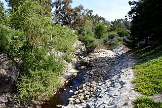
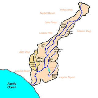
Aliso Creek is a 19.8-mile (31.9 km)-long, mostly urban stream in south Orange County, California. Originating in the Cleveland National Forest in the Santa Ana Mountains, it flows generally southwest and empties into the Pacific Ocean at Laguna Beach. The creek's watershed drains 34.9 square miles (90 km2), and it is joined by seven main tributaries. As of 2018, the watershed had a population of 144,000 divided among seven incorporated cities.
Oso Creek is an approximately 13.5-mile (21.7 km) tributary of Arroyo Trabuco in southern Orange County in the U.S. state of California. Draining about 20 square miles (52 km2) in a region north of the San Joaquin Hills and south of the Santa Ana Mountains, the creek is Trabuco Creek's largest tributary, and is part of the San Juan Creek drainage basin. Beginning in the foothills of the Santa Ana Mountains near the city of Mission Viejo, the creek is dammed twice to form Upper Oso Reservoir and Lake Mission Viejo. The creek is channelized and polluted along much of its length.
Arroyo Trabuco is a 22-mile (35 km)-long stream in coastal southern California in the United States. Rising in a rugged canyon in the Santa Ana Mountains of Orange County, the creek flows west and southwest before emptying into San Juan Creek in the city of San Juan Capistrano. Arroyo Trabuco's watershed drains 54 square miles (140 km2) of hilly, semi-arid land and lies mostly in Orange County, with a small portion extending northward into Riverside County. The lower section of the creek flows through three incorporated cities and is moderately polluted by urban and agricultural runoff.
Aliso and Wood Canyons Wilderness Park is a major regional park in the San Joaquin Hills of Orange County, California in the United States. Comprising 4,500 acres (1,800 ha) of rugged coastal canyons, open grassland, and riparian woodland, the park borders the suburban cities of Aliso Viejo, Dana Point, Laguna Beach, Laguna Hills and Laguna Niguel.
Salt Creek is a small coastal stream in southern Orange County in the U.S. state of California. The 4-mile (6.4 km) creek drains 6.1 square miles (16 km2) in parts of the cities of Laguna Niguel, Dana Point, and San Juan Capistrano. The mostly channelized creek has no named surface tributaries. The creek begins in the central portion of the city of Laguna Niguel and flows west and south through a narrow canyon referred to as the Salt Creek Corridor, which is mostly inside a long and narrow regional park. It then flows into the Monarch Beach Golf Course in the city of Dana Point and enters a subsurface storm channel which carries it to its discharge point at Salt Creek County Beach.
Santiago Creek is a major watercourse in Orange County in the U.S. state of California. About 34 miles (55 km) long, it drains most of the northern Santa Ana Mountains and is a tributary to the Santa Ana River. It is one of the longest watercourses entirely within the county. The creek shares its name with Santiago Peak, at 5,687 ft (1,733 m) the highest point in Orange County, on whose slopes its headwaters rise.
Wood Canyon Creek is a 2.8 mi (4.5 km) perennial stream in Aliso and Wood Canyons Wilderness Park, Orange County, California. A tributary of Aliso Creek, it drains a deep undeveloped valley to the west of Aliso Viejo.
Laguna Canyon is a canyon that cuts through the San Joaquin Hills in southern Orange County, California, in the United States, directly south of the city of Irvine. The canyon runs from northeast to southwest, and is drained on the north side by tributaries of San Diego Creek and on the south by Laguna Canyon Creek. It is deeper and more rugged on the southwestern end near Laguna Beach.
San Diego Creek is a 16-mile (26 km) urban waterway flowing into Upper Newport Bay in Orange County, California in the United States. Its watershed covers 112.2 square miles (291 km2) in parts of eight cities, including Irvine, Tustin, and Costa Mesa. From its headwaters in Laguna Woods the creek flows northwest to its confluence with Peters Canyon Wash, where it turns abruptly southwest towards the bay. Most of the creek has been converted to a concrete flood control channel, but it also provides important aquatic and riparian habitat along its course and its tidal estuary.
Sulphur Creek is a 4.5-mile (7.2 km) tributary of Aliso Creek in Orange County in the U.S. state of California. The creek drains about 6 square miles (16 km2) of residential communities and parks in the southern San Joaquin Hills.
Bell Canyon is a major drainage of the Santa Ana Mountains in Orange County, California in the United States. Bell Creek flows about 14.4 miles (23.2 km) in a southerly direction to its confluence with San Juan Creek. The Bell Canyon drainage is located to the east and parallel to Cañada Gobernadora, and to the south of Trabuco Creek. After Trabuco Creek, it is the second largest tributary of San Juan Creek in terms of length and its watershed area of 26 square miles (67 km2).
San Mateo Creek is a stream in Southern California in the United States, whose watershed mostly straddles the border of Orange and San Diego Counties. It is about 22 miles (35 km) long, flowing in a generally southwesterly direction. Draining a broad valley bounded by the Santa Ana Mountains and Santa Margarita Mountains, San Mateo Creek is notable for being one of the last unchannelized streams in Southern California.
Laguna Coast Wilderness Park is a 7,000-acre (2,800 ha) wilderness area in the San Joaquin Hills surrounding Laguna Beach, California. This park features coastal canyons, ridgeline views and the only natural lakes in Orange County, California. Trails are maintained for hiking and mountain biking with a wide range of difficulty, from beginner to expert. Most trails gain in height, reaching a maximum of 1,000 feet (300 m) in elevation. Several trails lead to downtown Laguna Beach.
Orange County Parks, more commonly abbreviated to OC Parks, is a government agency that maintains and oversees the public parks of Orange County, California. The agency operates both natural and manmade parks of the region. OC Parks is responsible for 60,000 acres (24,000 ha) of inland and coastal open space that collectively receives millions of visitors every year.
Coordinates: 33°34′11″N117°30′35″W / 33.56972°N 117.50972°W