
Laguna Niguel is a city in Orange County, California, United States. The name Laguna Niguel is derived from the words "Laguna" and "Niguili". As of the 2020 census, the population was 64,355. Laguna Niguel is located in the San Joaquin Hills in the southeastern corner of Orange County, close to the Pacific Ocean, and borders the cities of Aliso Viejo, Dana Point, Laguna Beach, Laguna Hills, Mission Viejo, and San Juan Capistrano.

Lake Lansing is a 461-acre (1.9 km2) lake in Haslett, Michigan just a few miles northeast of the state's capital city of Lansing.

Babcock State Park is a state park located along the New River Gorge on 4,127 acres (16.7 km2) wooded in Fayette County, West Virginia. It is located approximately 20 miles away from the New River Gorge Bridge.

Kettle Creek State Park is a 1,793-acre (726 ha) Pennsylvania state park in Leidy Township, Clinton County, Pennsylvania in the United States. The park is in a valley and is surrounded by mountains and wilderness. It features the Alvin R. Bush Dam built in 1961 by the U.S. Army Corps of Engineers as a flood control measure in the West Branch Susquehanna River basin. Many of the recreational facilities at the park were built during the Great Depression by the young men of the Civilian Conservation Corps. Kettle Creek State Park is seven miles (10 km) north of Westport and Pennsylvania Route 120. It is largely surrounded by Sproul State Forest.

Bald Eagle State Park is a 5,900-acre (2,388 ha) Pennsylvania state park in Howard, Liberty, and Marion townships in Centre County, Pennsylvania in the United States. The park includes the Foster Joseph Sayers Reservoir, formed by damming Bald Eagle Creek and other smaller streams and covering 1,730 acres (700 ha). Bald Eagle State Park is at the meeting point of two distinct geologic features. The Allegheny Plateau is to the north and the Ridge and Valley area of Pennsylvania is to the south. The park is in the Bald Eagle Valley off Pennsylvania Route 150 in Howard, between Milesburg and Lock Haven.
Ralph B. Clark Regional Park is an urban park located in the cities of Fullerton and Buena Park, California. The park is maintained by Orange County Regional Parks, the government division that controls the regional parks in Orange County. The park is south of Rosecrans Avenue at the southern edge of the West Coyote Hills in Buena Park, but both a small section named Camel Hill next to the main park area south of Rosecrans and another small section of the park with six softball fields and a trail located north of Rosecrans Avenue are within Fullerton city limits. The park was originally opened as Los Coyotes Regional Park in 1981, and was renamed in 1987 after then-retiring Orange County Supervisor Ralph B. Clark (1917–2009).

Mt. Pisgah State Park is a 1,302-acre (527 ha) Pennsylvania state park in Smithfield, Springfield, Troy and West Burlington Townships, Bradford County, Pennsylvania in the United States. The park is located almost exactly halfway between Troy and Towanda, along Pennsylvania State Route 3019, near U.S. Route 6, at the base of Mt. Pisgah. The park is bordered by Mill Creek, Mt. Pisgah County Park and State Game Land 289. Mill Creek which flows through the park has been dammed and forms Stephen Foster Lake a 75-acre (30 ha) man-made lake.

Henderson Park is a 47 hectare park located in Lethbridge, Alberta, Canada. The park contains many amenities and attractions, including a 24 hectare man-made lake, the largest lake in the city. Several annual events are held in the park.

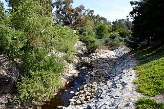
Aliso Creek is a 19.8-mile (31.9 km)-long, mostly urban stream in south Orange County, California. Originating in the Cleveland National Forest in the Santa Ana Mountains, it flows generally southwest and empties into the Pacific Ocean at Laguna Beach. The creek's watershed drains 34.9 square miles (90 km2), and it is joined by seven main tributaries. As of 2018, the watershed had a population of 144,000 divided among seven incorporated cities.
Oso Creek is an approximately 13.5-mile (21.7 km) tributary of Arroyo Trabuco in southern Orange County in the U.S. state of California. Draining about 20 square miles (52 km2) in a region north of the San Joaquin Hills and south of the Santa Ana Mountains, the creek is Trabuco Creek's largest tributary, and is part of the San Juan Creek drainage basin. Beginning in the foothills of the Santa Ana Mountains near the city of Mission Viejo, the creek is dammed twice to form Upper Oso Reservoir and Lake Mission Viejo. The creek is channelized and polluted along much of its length.

Aliso and Wood Canyons Wilderness Park is a major regional park in the San Joaquin Hills of Orange County, California in the United States. Comprising 4,500 acres (1,800 ha) of rugged coastal canyons, open grassland, and riparian woodland, the park borders the suburban cities of Aliso Viejo, Dana Point, Laguna Beach, Laguna Hills and Laguna Niguel.

Laguna Niguel Lake, formerly known as Sulphur Creek Reservoir, is an artificial 44-acre (180,000 m2) fishing and recreational lake in Laguna Niguel, California. It is created by the Sulphur Creek Dam, which was completed in 1966. It is located at 33°32′59″N117°42′22″W and is 190 feet (58 m) above sea level. It is fed from two sources, one of which is Sulphur Creek itself and the other, a storm drain. It is accessed from La Paz Road, which runs along its east shore. Surrounding the reservoir is the Laguna Niguel Regional Park. In addition, within the lake on the large island is a protected bird sanctuary.

Sulphur Creek is a 4.5-mile (7.2 km) tributary of Aliso Creek in Orange County in the U.S. state of California. The creek drains about 6 square miles (16 km2) of residential communities and parks in the southern San Joaquin Hills.

Salt Creek Beach Park is a beach park located in Dana Point, California, in the county of Orange. A popular destination for South Orange County residents, it features amenities such as a halfcourt basketball court, beach volleyball, and a seven-acre grassy Bluff Park, and offers opportunities for surfing, swimming, and fishing. It is located about 10 miles (16 km) south of Laguna Beach, 70 miles (110 km) north of San Diego, and 45 miles (72 km) south of Los Angeles.
Tenkiller State Park is a 1,190-acre (4.8 km2) Oklahoma state park located in northwestern Sequoyah County, Oklahoma, near the city of Vian, Oklahoma. Larger cities nearby include Sallisaw, Muskogee and Webbers Falls, Oklahoma.

Sulphur Creek Dam is a dam across Sulphur Creek in Orange County, California. The dam creates Laguna Niguel Lake and is entirely within the city of Laguna Niguel. The reservoir is used for water reclamation storage and recreation, and is the main attraction of Laguna Niguel Regional Park, which surrounds it.

Bear Creek Regional Park and Nature Center is a regional park located in Colorado Springs, Colorado that has trails for hiking, horseback riding, running and cycling. Within the park is a nature center and the El Paso Park Headquarters.
The Manitou Park Recreation Area is a recreation area in the Pike National Forest, located 5.2 miles (8.4 km) north of Woodland Park along Colorado State Highway 67 in Teller County, Colorado. The recreation area includes several campgrounds and a picnic area, the Manitou Lake Picnic Area.

Carbon Canyon Regional Park is a regional park in Brea, California, that was created after the Carbon Canyon Creek was dammed. It links up with Chino Hills State Park on the east side. The park also is home to a small forest of Redwood trees, which have been struggling to survive since the start of the 2010 California drought.

Lewis and Clark State Recreation Area (SRA) is an 864-acre State Recreation Area located on the southern shore of Lewis and Clark Lake, in northeastern Nebraska. The recreation area is located in Knox County, approximately 12 miles (19 km) northwest of Crofton. The recreation area is managed by the Nebraska Game and Parks Commission.


