Valley Village, Los Angeles

Last updated
Valley Village
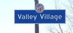
Valley Village Neighborhood Signage.jpg
Valley Village signage located at the intersection of Burbank Boulevard
and Laurel Canyon Avenue
Flag of Valley Village.png
Location map San Fernando Valley.png
Red pog.svg
Valley Village
Location in the San Fernando Valley
Coordinates: 34°09′54″N118°23′47″W / 34.16488°N 118.39650°W / 34.16488; -118.39650
Country United States
State California
County Los Angeles
Area
  Total2.08 sq mi (5.39 km2)
Population
 (2010)
  Total24,330
  Density11,690/sq mi (4,514/km2)
Time zone Pacific
Zip Code
91401, 91423, 91601, 91602, 91607
Area code(s) 747, 818
Website myvalleyvillage.com

Valley Village is a neighborhood in the city of Los Angeles, located within the San Fernando Valley.

Contents

History

Founding

According to Elke Garman, co-president of the Valley Village Homeowners Association in 1991, the history of Valley Village went back to the 1930s, when workers at nearby motion picture studios built houses there. The local post office on Magnolia Boulevard canceled all mail with a "Valley Village" postmark. It was, however, officially a section of North Hollywood. [1]

On page 30 of his autobiography Endless Highway, David Carradine says: [2]

The San Fernando Valley is a really hot, dry place in the summer. I spent most of my time in swimming trunks, sitting in the upper branches of a giant apricot tree that grew at the corner of the farm, eating apricots and stuffing my trunks full of them to take home.

In 1939, when we moved there, Valley Village was an isolated two-block town in the middle of miles and miles of orange and walnut groves, peach orchards, and cornfields. It was situated at what you might call the end of Los Angeles: the city, the county, and the idea. Across the street from the house was a dirt farm, usually in corn: acres and acres of it. After that, there were no more streets. The edge of the city.

In the other direction from the house was an empty lot; well, that's what we called it. It was actually a peach orchard.

Separation from North Hollywood

The idea of separating Valley Village from North Hollywood was brought into public light with a meeting of about 300 homeowners at Colfax Avenue Elementary School in December 1985, [3] yet it wasn't until 1991 that Valley Village got seven new blue reflective markers from the city of Los Angeles to mark its borders. [1]

Reporter James Quinn of the Los Angeles Times wrote that Valley Village no longer wanted to be associated with North Hollywood, "a community that has grown old, heavily Latino and crime-plagued," but, in the same article, Valley Village leader Tom Paterson was quoted as saying that the move "was more than an attempt to boost property values" and that it "had nothing to do with ethnic demographics." Rather, he said, "It was one economic level seeking to have its own identity." [4] Quinn wrote that:

Houses along Valley Village's lushly landscaped, graffiti-free streets cost up to $800,000, and a two-bedroom, two-bath entry-level house will run $300,000, residents say. Elsewhere in North Hollywood, that same size entry-level house can be purchased for as little as $150,000, real estate agents say. And the cheaper house is likely to have an overgrown, dusty yard and to be in a neighborhood reeling from crime, with gang graffiti splattered on block walls and street signs. [4]

"Stucco mountains"

In December 1985, some three hundred homeowners gathered at Colfax Avenue Elementary School to begin a campaign to head off development of what they called "stucco mountains" – continued construction of large apartments and office buildings in the area. Councilman Joel Wachs said he would support the drive, although he rejected the details of a proposed advisory panel for the area. He said a proposed panel of homeowners might overlook the concerns of renters and the need for rental housing. [3] Residents complained about blocked views, parking problems and traffic congestion because of buildings as high as five stories next to their single-family homes. [5]

The measure would not have banned construction but would have limited all new buildings to two stories and the square footage of commercial development to 1 1/2 times the size of the lot. The plan had the support of Valley Village resident Tom Paterson, president of the Valley Village Homeowners Association, but the opposition of, for one, Marvin Eisenman, an apartment-building owner who said it would not be fair to landowners who purchased property with the idea of developing it. [6] It was touted as a temporary measure until city planners could conduct public hearings on new, permanent development limits. [7] On September 17, 1986, the City Council approved the idea on a 10–2 vote, [8] but less than a month later it reversed itself after heavy lobbying – by former Councilman Arthur K. Snyder, among others – and sent the ordinance back to committee, with the idea that it could be brought back with exemptions for areas where development had already occurred. [7] Finally, substantially the same measure was approved by the council on a temporary basis with exemptions for two dozen properties in areas where there had already been substantial development, like the south side of Riverside Drive between Colfax Avenue and Laurel Canyon Boulevard. [5]

Eventually, the Los Angeles city Planning Commission recommended that a three-story limit be adopted for the Valley Village area. [9]

Geography

City of Los Angeles

The boundaries of Valley Village as delineated by the Valley Village Neighborhood Council are Burbank Blvd to the north, the Tujunga Wash to the west, the Ventura Freeway (US 101) to the south and CA 170 to the east. [10]

An intersection in Valley Village Valley Village, Los Angeles, CA, USA - panoramio (9).jpg
An intersection in Valley Village

Google Maps

The boundaries of Valley Village as delineated by Google Maps are Burbank Blvd to the north, the Tujunga Wash to the west, the Ventura Freeway (US 101) to the south and CA 170 to the east. [11]

Valley Village, as mapped by the Los Angeles Times Map of Valley Village, Los Angeles, California.png
Valley Village, as mapped by the Los Angeles Times

The Los Angeles Times' Mapping L.A. Project

The Los Angeles Times' Mapping L.A. Project delineates the Valley Village borders as Burbank Blvd. to the north, the Hollywood Freeway to the east, the Ventura Freeway to the south and Coldwater Canyon Avenue to the west. [12]

The 2.09-square-mile (5.4 km2) neighborhood lies north of Studio City, east of Sherman Oaks, and south and west of North Hollywood.

Climate

Located within the San Fernando Valley, Valley Village has a higher degree of diurnal temperature variation than the nearby basin or coastal areas. According to the Köppen climate classification system, Valley Village has a hot-summer Mediterranean climate (Csa), with subtropical and semi-arid characteristics. Summers are long, hot, dry and smoggy, with average high temperatures in the mid-80s to lower-90s °F (30–34 °C), with nighttime lows in the upper-50s to lower-60s °F (14–17 °C). Temperatures reach or surpass 100 °F (38 °C) several times during the summer, raising the risk of heat stroke or other heat-related illnesses. The all-time record high temperature in Valley Village is 117 °F (47 °C), recorded on September 6, 2020.

Winters are short, sunny and typically warm, with average high temperatures in the upper-60s to lower-70s °F (20–23 °C), but with chilly nights in the lower-to-mid 40s °F (4–7 °C). Winter is also the wet season, but rain is usually infrequent, even during the winter months, as most of the area's rain comes from Pacific storms. It can be especially rainy during El Niño cycles, with flash flooding sometimes occurring. Sub-freezing temperatures (32 °F, 0 °C) and below, as well as frosts, occur several times during the winter; however, these cold weather events are typically brief, usually only lasting for a day or two before temperatures return to normal. Snow is extremely rare. The all-time record low temperature in Valley Village is 23 °F (–5 °C), recorded on January 29, 1979.

Spring and fall hardly exist in this climate, with these months typically being sunny and warm. The Santa Ana winds typically occur between fall and spring, lowering humidity levels and raising temperatures, which increases the risk for wildfires. During the late spring and early summer, more specifically in the months of May and June, conditions are often overcast and foggy, a phenomenon known by local residents as "May Gray" or "June Gloom".

Climate data for Valley Village, Los Angeles
MonthJanFebMarAprMayJunJulAugSepOctNovDecYear
Record high °F (°C)92
(33)
92
(33)
98
(37)
103
(39)
105
(41)
114
(46)
115
(46)
112
(44)
117
(47)
106
(41)
97
(36)
93
(34)
117
(47)
Mean daily maximum °F (°C)67.4
(19.7)
68.1
(20.1)
71.0
(21.7)
74.5
(23.6)
78.7
(25.9)
84.0
(28.9)
90.3
(32.4)
91.9
(33.3)
88.7
(31.5)
81.2
(27.3)
73.6
(23.1)
67.1
(19.5)
78.0
(25.6)
Mean daily minimum °F (°C)42.1
(5.6)
43.4
(6.3)
45.6
(7.6)
48.6
(9.2)
53.3
(11.8)
57.0
(13.9)
61.0
(16.1)
61.2
(16.2)
59.1
(15.1)
52.8
(11.6)
45.6
(7.6)
41.2
(5.1)
50.9
(10.5)
Record low °F (°C)23
(−5)
26
(−3)
28
(−2)
30
(−1)
32
(0)
36
(2)
40
(4)
41
(5)
39
(4)
31
(−1)
28
(−2)
26
(−3)
23
(−5)
Average precipitation inches (mm)3.94
(100)
4.32
(110)
3.51
(89)
0.84
(21)
0.27
(6.9)
0.06
(1.5)
0.01
(0.25)
0.17
(4.3)
0.25
(6.4)
0.50
(13)
1.19
(30)
2.05
(52)
17.12
(435)
Source 1: [13]
Source 2: [14]

Housing

In 1994, the Los Angeles Times called Valley Village an "area of upscale residences." [15] The 2000 census found that renters occupied 68.7% of the housing units, and homeowners occupied the remaining 31.3%. [12] In 2006, Valley Village was described in another article as a neighborhood "mostly of 1,700 sqft, single-story Spanish- and ranch-style homes that typically sit on nice-size lots." Most of the 3,881 single-family homes were on residential streets, and 1,073 condos and 8,213 apartment units lined the main boulevards. [16]

Population

A total of 24,190 people lived in Valley Village's 2.09 square miles, according to the 2000 U.S. census – averaging 11,600 people per square mile, about average for Los Angeles. Population was estimated at 25,665 in 2008. With its percentage of white people considered high for Los Angeles County, Valley Village is still moderately diverse in its ethnic makeup, with a diversity index of 0.512. "The diversity index measures the probability that any two residents, chosen at random, would be of different ethnicities. If all residents are of the same ethnic group it's zero. If half are from one group and half from another it's .50." [17] Whites made up 66.7% of the population, Latinos were 18.9%, with black people at 5.5% and Asians and others both at 4.4%. The median age was 36, considered old when compared to the city as a whole. [12] There is a sizable Jewish community. [18]

The $55,470 median household income in 2008 dollars was average for the city and county. The average household size of two people was low for both the city and the county. The percentages of divorced men, divorced women, never-married men and widowed women were among the county's highest. [12]

Education

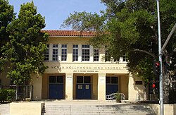
North Hollywood Senior High School NHHS Kennedy Hall.jpg
North Hollywood Senior High School

Schools within Valley Village are:

High schools:

Continuation school:

Elementary schools:

Valley Village Park ValleyVillagePark.jpeg
Valley Village Park

Parks and recreation

Marilyn Monroe house

Marilyn Monroe while living in Valley Village, 1945 MarilynMonroe - YankArmyWeekly.jpg
Marilyn Monroe while living in Valley Village, 1945

A house at 5258 Hermitage Avenue, [20] where film actress Marilyn Monroe lived in 1944–45 under her married name of Norma Jean Dougherty, was demolished by a property developer to make way for a condominium project in June 2015 even as it was under consideration as a historic landmark. She lived there at age 17 while her husband, James Dougherty, was in the Navy, and she had a job inspecting parachutes at a nearby factory. She was living there when she was asked to pose for her first pin-up photo. It was said, however, that the chances of the house being declared a landmark were slim because, as Ken Bernstein, director of the city's Office of Historic Resources, put it, "There are hundreds, if not thousands, of houses associated with celebrities. [21] [22] Monroe resided at the property for only one year "and did not live in the unit during the productive period of her career," a report by city planning officials said. [23]

In October 2015, Los Angeles was facing a lawsuit over the house's destruction by a group called Save Valley Village. At issue was the City Council's practice of "automatically heeding the wishes" of the council member who represents any given area in a controversy. The group said it also had "overwhelming evidence" that an environmental report should have been prepared for the condo project. The group also asked that the city nullify any development projects that received unanimous support during the previous twelve months. [23]

Notable residents

Twin towns

Valley Village is twinned with Saint-Nom-la-Bretèche, France.

Related Research Articles

<span class="mw-page-title-main">Hollywood, Los Angeles</span> Neighborhood in Los Angeles, California, US

Hollywood, sometimes informally called Tinseltown, is a neighborhood in the central region of Los Angeles County, California, mostly within the city of Los Angeles. Its name has come to be a shorthand reference for the U.S. film industry and the people associated with it. Many notable film studios, such as Sony Pictures, Walt Disney Studios, Paramount Pictures, Warner Bros. and Universal Pictures, are located near or in Hollywood.

<span class="mw-page-title-main">San Fernando Valley</span> Valley in California, US

The San Fernando Valley, known locally as the Valley, is an urbanized valley in Los Angeles County, California. Situated northwards of the Los Angeles Basin, it comprises a large portion of Los Angeles, the incorporated cities of Burbank, Calabasas, Glendale, Hidden Hills and San Fernando, plus several unincorporated areas. The valley is the home of Warner Bros. Studios, Walt Disney Studios, and the Universal Studios Hollywood theme park.

<span class="mw-page-title-main">Westwood, Los Angeles</span> Neighborhood of Los Angeles in California, United States

Westwood is a commercial and residential neighborhood in the northern central portion of the Westside region of Los Angeles, California. It is the home of the University of California, Los Angeles (UCLA). Bordering the campus on the south is Westwood Village, a major regional district for shopping, dining, movie theaters, and other entertainment.

<span class="mw-page-title-main">Los Feliz, Los Angeles</span> Neighborhood of Los Angeles in California, United States

Los Feliz is a hillside neighborhood in the greater Hollywood area of Los Angeles, California, abutting Hollywood and encompassing part of the Santa Monica Mountains. The neighborhood is named after the Feliz family of Californios who had owned the area since 1795, when José Vicente Féliz was granted Rancho Los Feliz.

<span class="mw-page-title-main">North Hollywood, Los Angeles</span> Neighborhood in Los Angeles, California, United States of America

North Hollywood is a Los Angeles, California neighborhood, located in the San Fernando Valley. The neighborhood contains the NoHo Arts District, El Portal Theater, several art galleries, and the Academy of Television Arts & Sciences. The North Hollywood Metro Rail station is the northern terminus of the B Line subway on the Los Angeles Metro.

<span class="mw-page-title-main">Sun Valley, Los Angeles</span> Neighborhood of Los Angeles in California, United States

Sun Valley is a neighborhood in Los Angeles, California in the San Fernando Valley region. The neighborhood is known for its overall youthful population. There are three recreation centers in Sun Valley, one of which is a historic site. The neighborhood has thirteen public schools—including John H. Francis Polytechnic High School and Valley Oaks Center for Enriched Studies (VOCES)—and four private schools.

<span class="mw-page-title-main">Palms, Los Angeles</span> Neighborhood of Los Angeles, California,

Palms is a community in the Westside region of Los Angeles, California, founded in 1886 and the oldest neighborhood annexed to the city, in 1915. The 1886 tract was marketed as an agricultural and vacation community. Today it is a primarily residential area, with many apartment buildings, ribbons of commercial zoning and a single-family residential area in its northwest corner. As of the 2000 census the population of Palms was 42,545.

Beverlywood is a neighborhood in the Westside of the city of Los Angeles, California.

<span class="mw-page-title-main">Mar Vista, Los Angeles</span> Neighborhood of Los Angeles in California, United States of America

Mar Vista is a neighborhood on the Westside of Los Angeles, California. In 1927, Mar Vista became the 70th community to be annexed to Los Angeles. It was designated as an official city neighborhood in 2006.

<span class="mw-page-title-main">Pico-Union, Los Angeles</span> Neighborhood of Los Angeles in California, United States of America

Pico-Union is a neighborhood in Central Los Angeles, California. The name "Pico-Union" refers to the neighborhood that surrounds the intersection of Pico Boulevard and Union Avenue. Located immediately west of Downtown Los Angeles, it is home to over 40,000 residents.

<span class="mw-page-title-main">East Hollywood, Los Angeles</span> Neighborhood of Los Angeles in California, United States

East Hollywood is a densely populated neighborhood of 78,000+ residents that is part of the Hollywood area of the central region of Los Angeles, California. It is notable for being the site of Los Angeles City College, Barnsdall Park, and a hospital district. There are seven public and five private schools, a Los Angeles Public Library branch, and three hospitals. Almost two-thirds of the people living there were born outside the United States, and 90% were renters. In 2000, the neighborhood had high percentages of never-married people and single parents.

Mid-Wilshire is a neighborhood in the central region of Los Angeles, California. It is known for the Los Angeles County Museum of Art, the Petersen Automotive Museum, and the Miracle Mile shopping district.

<span class="mw-page-title-main">Mid City, Los Angeles</span> Neighborhood of Los Angeles in California, United States of America

Mid City is a neighborhood in Central Los Angeles, California.

Shadow Hills is a neighborhood in the Verdugo Mountains and northeastern San Fernando Valley, within the city of Los Angeles, California.

<span class="mw-page-title-main">California's 29th congressional district</span> U.S. House district for California

California's 29th congressional district is a congressional district in the U.S. state of California based in the north central San Fernando Valley. The district is represented by Democrat Tony Cárdenas.

<span class="mw-page-title-main">University Park, Los Angeles</span> Neighborhood of Los Angeles in California, United States

University Park is a 1.17 square miles (3.0 km2) neighborhood in the South Los Angeles region of Los Angeles, California. The area includes the University of Southern California (USC), and the residential neighborhoods located immediately north of the campus: North University Park, Chester Place and St. James Park.

<span class="mw-page-title-main">Valley Glen, Los Angeles</span> Neighborhood of Los Angeles in California, United States of America

Valley Glen is a neighborhood in the southeastern section of the San Fernando Valley in Los Angeles, California. Once part of Van Nuys and North Hollywood, it became a separate neighborhood in 1998. Valley Glen is home to Los Angeles Valley College and the Great Wall of Los Angeles, a half-mile-long California-history mural listed on the National Register of Historic Places.

Victory Boulevard is a major mostly east–west arterial road that runs for 25 miles (40 km) traversing the entire length of the San Fernando Valley in Los Angeles, California. About two miles of the boulevard runs north-south before reaching its eastern terminus.

<span class="mw-page-title-main">Sunland-Tujunga, Los Angeles</span> Neighborhood of Los Angeles in California, United States

Sunland-Tujunga is a Los Angeles city neighborhood within the Crescenta Valley and Verdugo Mountains. Sunland and Tujunga began as separate settlements and today are linked through a single police station, branch library, neighborhood council, chamber of commerce, city council district, and high school. The merging of these communities under a hyphenated name goes back as far as 1928. Sunland-Tujunga contains the highest point of the city, Mount Lukens.

<span class="mw-page-title-main">Exposition Park, Los Angeles</span> Neighborhood in California, US

Exposition Park is a neighborhood in the south region of Los Angeles, California. It is home to Exposition Park, which includes the Los Angeles Memorial Coliseum, BMO Stadium, Exposition Rose Garden and three museums: the California African American Museum, the California Science Center and the Natural History Museum of Los Angeles County. It is also home to a Science Center Academy.

References

  1. 1 2 Aaron Curtiss, "Name Changes, Neighborhood Doesn't," Los Angeles Times, February 13, 1991
  2. David Carradine (1995). Endless Highway. Journey Editions. p. 647. ISBN   1-885203-20-9.
  3. 1 2 Marc Igler, "North Hollywood Growth Cap Sought," Los Angeles Times, December 19, 1985
  4. 1 2 Quinn, James (June 14, 1992). "Most Profound Changes Sweep N. Hollywood". Los Angeles Times .
  5. 1 2 Richard Simon, "Council Enacts Building Limits on High-Rises in Valley Village," Los Angeles Times, November 19, 1986
  6. Thomas Omestad, "Ferraro Backs Growth Curbs for Valley Village," Los Angeles Times, October 10, 1986
  7. 1 2 Richard Simon, "Lobbied Council Flip-Flops on Builder Curbs," Los Angeles Times, October 15, 1986
  8. Richard Simon, "Council Approves North Hollywood High-Density Limits," Los Angeles Times, September 18, 1986
  9. Tracey Kaplan, "L.A. Planners OK 3-Story Buildings in North Hollywood," Los Angeles Times, November 10, 1989
  10. "The Valley Village neighborhood as indicated by the Valley Village Neighborhood Council". Neighborhood Council Valley Village. Retrieved 8 September 2019.
  11. "The Valley Village neighborhood as indicated on Google Maps" (Map). Google Maps . Retrieved 13 September 2019.
  12. 1 2 3 4 Mapping L.A., Valley Village
  13. "Zipcode 91607". www.plantmaps.com. Retrieved April 3, 2021.
  14. "Los Angeles, California Climate". www.bestplaces.net. Retrieved March 11, 2022.
  15. Ron Galperin, "What's in a Name? Residents Work to Change Community Names in Effort to Improve Image, Distance Themselves From Troubled Areas," Los Angeles Times, November 6, 1994
  16. Diane Wedner, "Village Locals Say It's a Slice of the Sweet Life," Los Angeles Times, January 29, 2006
  17. "Diversity," Mapping L.A., Los Angeles Times
  18. Roslyn Rozbruch, "New Name Adds Pride to Friendly Town," Los Angeles Times, August 16, 1992
  19. . "Valley Village Park" Retrieved on July 30, 2014.
  20. Location of Marilyn Monroe house on Mapping L.A.
  21. Dana Bartholomew, "Former Marilyn Monroe House in Valley Village Razed While Poised for Potential Preservation," Los Angeles Dailu News, June 16, 2015
  22. Bianca Barragan, "The Valley Village House Where Marilyn Monroe Got Her Start Was Just Demolished," Curbed Los Angeles, June 17, 2015
  23. 1 2 Emily Alpert Reyes, "Lawsuit Seeks to Block a Condo Project Where Marilyn Monroe Once Lived," Los Angeles Times, October 5, 2015
  24. "Valley Village singer responds to Ferguson with YouTube protest song". Ron Hasse. Los Angeles Daily News. November 28, 2014. Retrieved 24 March 2023.