Forest Heights, Maryland | |
---|---|
Town of Forest Heights | |
Coordinates: 38°48′43″N76°59′49″W / 38.81194°N 76.99694°W | |
Country | United States of America |
State | Maryland |
County | Prince George's |
Incorporated | 1949 [1] |
Area | |
• Total | 1.75 sq mi (4.54 km2) |
• Land | 1.65 sq mi (4.28 km2) |
• Water | 0.10 sq mi (0.25 km2) |
Elevation | 161 ft (49 m) |
Population (2020) | |
• Total | 2,658 |
• Density | 1,607.01/sq mi (620.39/km2) |
Time zone | UTC-5 (Eastern (EST)) |
• Summer (DST) | UTC-4 (EDT) |
ZIP code | 20745 |
Area code(s) | 301, 240 |
FIPS code | 24-28725 |
GNIS feature ID | 0597408 |
Website | forestheightsmd |
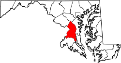
Forest Heights is a town in Prince George's County, Maryland, United States, and is part of the larger postal designation of Oxon Hill. [3] The town straddles both sides of dual-lane Maryland Route 210 and includes two elementary schools. Per the 2020 census, the population was 2,658. [4]
A few homes (such as on Huron Drive) were built in the 1930s, but most of the town developed in the 1940s and early 1950s, consisting of single-family homes with some streets of duplex homes; the Talbert Drive homes were added in the 1960s. In those days many town residents were scientists (as Mayor Armhold was) at the adjacent U.S. Naval Research Laboratory, while others were military band musicians or other Federal employees. The town's population was approximately 3,600 in 1960, almost 50% more than the 2010 population of 2,447, perhaps due to households having more children in 1960.[ citation needed ]
Two especially long-serving mayors were Clifford Armhold and Warren F. Adams.
After decades of former governmental stability, in the 2000s the town made headlines repeatedly as two of its recent mayors were embroiled in clashes with the town council. [5] One mayor, Joyce Beck, was ousted from office after changes to the Town Charter. [5] In June 2009 her successor, Myles Spires, filed a $15 million lawsuit against the town for malicious prosecution after being cleared of all charges initiated by the town for misuse of town's funds. [6] In 2019, the town annexed 446.88 acres of additional land, more than doubling its size. [7]
Forest Heights is located at 38°48′43″N76°59′49″W / 38.81194°N 76.99694°W (38.811863, -76.996809). [8] According to the United States Census Bureau, the town has a total area of 0.48 square miles (1.24 km2), all land. [9]
Census | Pop. | Note | %± |
---|---|---|---|
1950 | 1,125 | — | |
1960 | 3,524 | 213.2% | |
1970 | 3,497 | −0.8% | |
1980 | 2,999 | −14.2% | |
1990 | 2,859 | −4.7% | |
2000 | 2,585 | −9.6% | |
2010 | 2,447 | −5.3% | |
2020 | 2,658 | 8.6% | |
U.S. Decennial Census [10] 2010 [11] 2020 [12] |
Race / Ethnicity (NH = Non-Hispanic) | Pop 2010 [11] | Pop 2020 [12] | % 2010 | % 2020 |
---|---|---|---|---|
White alone (NH) | 174 | 113 | 7.11% | 4.25% |
Black or African American alone (NH) | 1,836 | 1,527 | 75.03% | 57.45% |
Native American or Alaska Native alone (NH) | 7 | 3 | 0.29% | 0.11% |
Asian alone (NH) | 95 | 73 | 3.88% | 2.75% |
Pacific Islander alone (NH) | 3 | 7 | 0.12% | 0.26% |
Some Other Race alone (NH) | 11 | 18 | 0.45% | 0.68% |
Mixed Race or Multi-Racial (NH) | 45 | 69 | 1.84% | 2.60% |
Hispanic or Latino (any race) | 276 | 848 | 11.28% | 31.90% |
Total | 2,447 | 2,658 | 100.00% | 100.00% |
As of the census [13] of 2010, there were 2,447 people, 868 households, and 619 families residing in the town. The population density was 5,097.9 inhabitants per square mile (1,968.3/km2). There were 927 housing units at an average density of 1,931.3 per square mile (745.7/km2). The racial makeup of the town was 11.9% White, 75.4% African American, 0.3% Native American, 3.9% Asian, 0.1% Pacific Islander, 5.8% from other races, and 2.6% from two or more races. Hispanic or Latino of any race were 11.3% of the population.
There were 868 households, of which 31.3% had children under the age of 18 living with them, 39.3% were married couples living together, 24.4% had a female householder with no husband present, 7.6% had a male householder with no wife present, and 28.7% were non-families. 22.7% of all households were made up of individuals, and 7.1% had someone living alone who was 65 years of age or older. The average household size was 2.82 and the average family size was 3.26.
The median age in the town was 41.1 years. 20.8% of residents were under the age of 18; 9.9% were between the ages of 18 and 24; 24.6% were from 25 to 44; 31.4% were from 45 to 64; and 13.4% were 65 years of age or older. The gender makeup of the town was 47.9% male and 52.1% female.
The town is served by its own Forest Heights Police Department, which maintains primary responsibility for the response to and prevention and investigation of the majority of all crimes within the corporate limits. [14] Under a memorandum of understanding, the Prince George's County Police Department serves as the secondary responding law enforcement agency for the town, and the primary investigating agency for most serious crimes, such as homicide or rape. Since 2019 the Chief of Police has been Anthony Rease.
The County Police Department maintains its District IV station just outside Forest Height's northern border at Eastover Shopping Center, in Glassmanor CDP. [15] Fire and rescue services are provided by Prince George's County Fire Department from neighboring Company 42 and Company 21, both in Oxon Hill.
The most prominent highway serving Forest Heights is Interstate 95/Interstate 495 (the Capital Beltway). I-495 follows the Capital Beltway around Washington, D.C., providing access to its many other suburbs. I-95 only follows the eastern portion of the beltway, diverging away from the beltway near both its north and south ends. To the north, I-95 passes through Baltimore, Philadelphia, New York City and Boston on its way to Canada, while to the south, it traverses Richmond on its way to Florida.
Maryland Route 210 and Maryland Route 414 also serve Forest Heights. MD 210 provides the direct access from Forest Heights to I-95/I-495, following Indian Head Highway from the Washington, D.C. border southward to Indian Head. MD 414 follows Saint Barnabas Road, running parallel to the Capital Beltway and providing local access to nearby communities.
Prince George's County Public Schools operates public schools serving Forest Heights. [16] There are two elementary schools in the town limits, Forest Heights and Flintstone; [16] these two schools serve separate portions of Forest Heights. [17] All residents are zoned to Oxon Hill Middle School and Potomac High School. [18] [19]
Prince George's County Memorial Library System operates the Oxon Hill Library in nearby Oxon Hill. [20] [21]
Prince George's County is a county located in the U.S. state of Maryland bordering the eastern portion of Washington, D.C. As of the 2020 U.S. census, the population was 967,201, making it the second-most populous county in Maryland, behind neighboring Montgomery County. The 2020 census counted an increase of nearly 104,000 in the previous ten years. Its county seat is Upper Marlboro. It is the largest and the second most affluent African American-majority county in the United States, with five of its communities identified in a 2015 top ten list. The county is part of the Central Maryland region of the state.
Berwyn Heights is a town in Prince George's County, Maryland, United States. Per the 2020 census, the population was 3,345. It is bordered by College Park to the west, Greenbelt to the northeast, and Riverdale Park to the south.
Camp Springs is an unincorporated area and census-designated place (CDP) in Prince George's County, Maryland, United States. The population was 22,734 at the 2020 census. Camp Springs is not an official post office designation; the area is divided among the surrounding mailing addresses of Temple Hills, Fort Washington, Clinton, and Suitland.
Capitol Heights is a town in Prince George's County, Maryland, United States, located on the border of both the Northeast & Southeast quadrants of Washington. Per the 2020 census, the population was 4,050. The town of Capitol Heights is officially bounded between Southern Avenue NE/SE to the north, Yost Place, and Eastern Avenue NE to the east, the Watts Branch Stream, Brooke Road, and Capitol Heights Boulevard to the south, and Marlboro Pike to the west. The zip code of Capitol Heights is 20743.
Fort Washington is an unincorporated area and census-designated place in Prince George's County, Maryland, United States. It borders the Potomac River, situated 20 miles south of downtown Washington, D.C. As of the 2020 census, it had a population of 24,261. The Fort Washington community is located west of Maryland Route 210, with some additional area to the east of the highway.
Glenarden is a city in Prince George's County, Maryland, United States. Per the 2020 census, the population was 6,402.
Hillcrest Heights is an unincorporated area and census-designated place (CDP) in Prince George's County, Maryland, United States. The population was 15,793 at the 2020 census. For mailing address purposes, it is part of the smaller community of Temple Hills and is also near Suitland.
Marlow Heights is an unincorporated area and census-designated place (CDP) in Prince George's County, Maryland, United States. The population was 6,169 at the 2020 census. The Marlow Heights Shopping Center first opened in 1957, adjacent to the large community of Hillcrest Heights. It was joined ten years later, in 1967, by the two-level Iverson Mall, the Washington metropolitan area's first enclosed mall.
Morningside is an incorporated town in Prince George's County, Maryland, United States. Per the 2020 census, the population was 1,240. The town developed with the establishment of nearby Andrews Air Force Base and the federal Census Bureau. The government of the town is led by a mayor and town council. Morningside Elementary School and Benjamin Foulois Junior High School/Elementary/Creative and Performing Arts Academy (current) as well as Michael J Polley Neighborhood Park are located within the town limits. Morningside has one of the largest VFW posts (chapters) in the entire country. Morningside is also the city of license of one of Washington's most prominent radio stations, from the 1960s to the present, WJFK and WPGC-FM. Additionally, Morningside is home to one of the busiest volunteer fire departments in Prince George's County, Morningside VFD Station 827. In 2015, station 827 ran over 8,000 calls for service with 150 working fires in Morningside and the adjacent communities, and has garnered national recognition for their service to the community.
North Brentwood is a town in Prince George's County, Maryland, United States. The population was 593 at the 2020 census. The municipality of North Brentwood is located north of Washington and is surrounded by the communities of Brentwood, Hyattsville, and Cottage City, and the nearby Mount Rainier. The Town of North Brentwood was incorporated in 1924, and was the first African-American-majority municipality in Maryland.
Oxon Hill-Glassmanor was a census-designated place (CDP) in Prince George's County, Maryland, for the 1990 and 2000 censuses. The combination is arbitrary, and in the mind of most local people there are two separate communities: Oxon Hill and Glassmanor. As of the 2010 census, Oxon Hill, National Harbor and Glassmanor were delineated as separate CDPs.
Seat Pleasant is an incorporated city in Prince George's County, Maryland, United States, located immediately east of Washington D.C.. Per the 2020 census, the population was 4,522. Two state highways pass through the community — Maryland routes 704 and 214. The Washington Metro's Blue and Silver Lines are nearby. The Washington Commanders' stadium is east of Seat Pleasant, near the Capital Beltway (I-95/495).
Temple Hills is an unincorporated area and census-designated place (CDP) in Prince George's County, Maryland, United States. Temple Hills borders the communities of Hillcrest Heights, Marlow Heights, Camp Springs and Oxon Hill. Per the 2020 census, the population was 8,350.
Hillandale is an unincorporated area and census-designated place located in Montgomery and Prince George's counties, Maryland, United States. As of the 2020 census, it had a population of 5,774. Hillandale is contained between the Prince George's / Montgomery County line to the east, the Anacostia River to the west, McCeney Avenue to the north, and D.C.'s Capital Beltway to the south. It borders the communities of Adelphi, Avenel, White Oak and Beltsville.
Landover is an unincorporated community and census-designated place in Prince George's County, Maryland, United States. As of the 2020 census, it had a population of 25,998.
Peppermill Village is an unincorporated community near Maryland Route 214 in Prince George's County, Maryland, United States. Per the 2020 census, the population was 5,264. FedExField, Metrorail's Blue Line, and Hampton Mall shopping center are all located nearby. Because it is not formally incorporated, it has no official boundaries, but the United States Census Bureau has defined a census-designated place (CDP) consisting of Peppermill Village and the adjacent community of Carmody Hills, for statistical purposes.
Oxon Hill is an unincorporated area and census-designated place (CDP) in southern Prince George's County, Maryland, United States. Oxon Hill is a suburb of Washington, located southeast of the downtown district and east of Alexandria, Virginia. Since 2008, it contains the 300-acre (120 ha) National Harbor development on the shore of the Potomac River.
Glassmanor is an unincorporated community and census-designated place in Prince George's County, Maryland, United States. As of the 2020 census, it had a population of 18,430. In the 1990 and 2000 censuses, the United States Census Bureau had placed Glassmanor and the adjacent community of Oxon Hill in the "Oxon Hill-Glassmanor" census-designated place for statistical purposes. Glassmanor was last delineated separately in 1980, when the CDP recorded a population of 7,751.
Suitland is a suburb of Washington, D.C., approximately one mile (1.6 km) southeast of Washington, D.C. Suitland is a census designated place (CDP), as of the 2020 census, its population was 25,839. Prior to 2010, it was part of the Suitland-Silver Hill census-designated place.
Potomac High School is a public high school located in the Glassmanor census-designated place in unincorporated Prince George's County, Maryland, United States, with an Oxon Hill postal address. It is a part of Prince George's County Public Schools.