Fairmount Heights, Maryland

Last updated
Fairmount Heights, Maryland
Town of Fairmount Heights
World War II Monument - Fairmount Heights, Maryland.jpg
World War II Monument
Seal of Fairmount Heights, Maryland.png
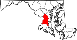
Prince George's County Maryland Incorporated and Unincorporated areas Fairmount Heights Highlighted.svg
Location of Fairmount Heights, Maryland
Coordinates: 38°54′6″N76°54′52″W / 38.90167°N 76.91444°W / 38.90167; -76.91444 Coordinates: 38°54′6″N76°54′52″W / 38.90167°N 76.91444°W / 38.90167; -76.91444
Country Flag of the United States.svg United States of America
State Flag of Maryland.svg  Maryland
County Flag of Prince George's County, Maryland (1963-present).svg Prince George's
Incorporated 1935
Government
  Type Mayor-council government
   Mayor Lillie Thompson-Martin
Area
[1]
  Total0.27 sq mi (0.69 km2)
  Land0.27 sq mi (0.69 km2)
  Water0.00 sq mi (0.00 km2)
Elevation
98 ft (30 m)
Population
 (2020)
  Total1,528
  Density5,766.04/sq mi (2,228.08/km2)
Time zone UTC-5 (Eastern (EST))
  Summer (DST) UTC-4 (EDT)
Zip Code
20743
Area code 301
FIPS code 24-27400
GNIS feature ID0597387
Website www.fairmountheightsmd.gov

Fairmount Heights is a town in Prince George's County, Maryland, United States. [2] Per the 2020 census, the population was 1,528. [3] The town was formally incorporated in 1935, making the town the second oldest African-American-majority municipality in Prince George's County. The town is composed of six subdivisions: Fairmount Heights (1900), Waterford (1907), Mount Weissner (1909), North Fairmount Heights (1910), West Fairmount Heights (1911) and Sylvan Vista (1923).

Contents

History

Two Washington, D.C. land developers and lawyers, Allen Clark and Robinson White, platted the first subdivision of Fairmount Heights; separate developers platted the remaining five. Land speculators had purchased the farms that were previously in the area and consolidated the land for development. Clark and White sold the lots to African-Americans. Service on the Washington, Baltimore and Annapolis Electric Railway to the Gregory Station of nearby Seat Pleasant was established in 1908. [4] Fairmount Heights incorporated in 1935 with all six subdivisions. The Fairmount Heights Historic District was added to the National Register of Historic Places in 2011. [5]

Mayors

(*)- Served as acting mayor

Government

The Town Council of Fairmount Heights consists of six elected councilmembers and an elected mayor who sits as chair of the council. The mayor and councilmembers are elected to serve for two years. The following are current officers of the town: [7]

Prince George's County Police Department District 3 Station in Landover CDP serves the community. [9]

Notable people

Historic sites

The following is a list of historic sites in Fairmount Heights identified by the Maryland-National Capital Park and Planning Commission. [10] On November 18, 2011, the Town of Fairmount Heights was added to the National Register of Historic Places as the Fairmont Heights Historic District. [11]

Site nameImageLocationM-NCPPC Inventory NumberComment
1 Samuel Hargrove House 5907 K Street72-009-17
2 W. Sidney Pittman House 505 Eastern Avenue72-009-18
3 Alice Dorsey House 910 59th Avenue72-009-23
4 Fairmount Heights (Grace) Methodist Episcopal Church 716 59th Avenue72-009-25
5 Trammell-Taylor House 717 59th Avenue72-009-26
6 Towles-Brooks House 708 59th Avenue72-009-27
7 Louis Brown House 701 58th Avenue72-009-28
8 World War II Monument Corner of 59th Avenue and 59th Place72-009-29
9 Isaac Brown House 715 59th Place72-009-30
10 William B. Coles House 730 60th Avenue72-009-31
11 John S. Johnson House 612 60th Place72-009-32
12 Henry Pinckney House 608 60th Place72-009-33
13 Cornelius Fonville House 602 60th Place72-009-35
14 Doswell Brooks House 6107 Foote Street72-009-36
15 Charity Hall 715 61st Avenue72-009-38
16 Robert S. Nichols House 802 58th Avenue72-009-39
17 Bungalow Row House #1 610 62nd Avenue72-009-41
18 Prince Albert Washington House 949 Eastern Avenue72-009-43
19 Bungalow Row House #2 700 62nd Avenue72-009-45
20 Bungalow Row House #3 709 62nd Avenue72-009-46
21 Bungalow Row House #4 711 62nd Avenue72-009-47
22 Tyrone and Caroline Bush House 5603 Addison Road72-009-48

Bordering areas

Geography

Fairmount Heights is located at 38°54′6″N76°54′52″W / 38.90167°N 76.91444°W / 38.90167; -76.91444 (38.901761, −76.914504). [12]

According to the United States Census Bureau, the town has a total area of 0.27 square miles (0.70 km2), all land. [13]

Demographics

Historical population
CensusPop.Note
1930 1,218
1940 1,39114.2%
1950 2,09750.8%
1960 2,30810.1%
1970 1,972−14.6%
1980 1,616−18.1%
1990 1,238−23.4%
2000 1,50821.8%
2010 1,494−0.9%
2020 1,5282.3%
U.S. Decennial Census [14]
2010 [15] 2020 [16]

2020 census

Fairmount Heights town, Maryland – Demographic Profile
(NH = Non-Hispanic)
Note: the US Census treats Hispanic/Latino as an ethnic category. This table excludes Latinos from the racial categories and assigns them to a separate category. Hispanics/Latinos may be of any race.
Race / EthnicityPop 2010 [15] Pop 2020 [16] % 2010% 2020
White alone (NH)15171.00%1.11%
Black or African American alone (NH)1,3131,09187.88%71.40%
Native American or Alaska Native alone (NH)600.40%0.00%
Asian alone (NH)12290.80%1.90%
Pacific Islander alone (NH)000.00%0.00%
Some Other Race alone (NH)020.00%0.13%
Mixed Race/Multi-Racial (NH)27441.81%2.88%
Hispanic or Latino (any race)1213458.10%22.58%
Total1,4941,528100.00%100.00%

2010 census

As of the census [17] of 2010, there were 1,494 people, 517 households, and 370 families residing in the town. The population density was 5,533.3 inhabitants per square mile (2,136.4/km2). There were 589 housing units at an average density of 2,181.5 per square mile (842.3/km2). The racial makeup of the town was 2.9% White, 88.6% African American, 0.4% Native American, 0.8% Asian, 5.3% from other races, and 1.9% from two or more races. Hispanic or Latino of any race were 8.1% of the population.

There were 517 households, of which 36.9% had children under the age of 18 living with them, 30.0% were married couples living together, 33.5% had a female householder with no husband present, 8.1% had a male householder with no wife present, and 28.4% were non-families. 24.2% of all households were made up of individuals, and 7.3% had someone living alone who was 65 years of age or older. The average household size was 2.88 and the average family size was 3.34.

The median age in the town was 37.3 years. 24.8% of residents were under the age of 18; 10.3% were between the ages of 18 and 24; 25.7% were from 25 to 44; 27.3% were from 45 to 64; and 12% were 65 years of age or older. The gender makeup of the town was 49.2% male and 50.8% female.

2000 census

As of the census [18] of 2000, there were 1,508 people, 498 households, and 361 families residing in the town. The population density was 5,622.7 inhabitants per square mile (2,170.9/km2). There were 561 housing units at an average density of 2,091.7 per square mile (807.6/km2). The racial makeup of the town was 1.13% White, 95.82% African American, 0.27% Native American, 0.07% Asian, 0.60% from other races, and 2.12% from two or more races. Hispanic or Latino of any race were 1.13% of the population.

There were 498 households, out of which 29.7% had children under the age of 18 living with them, 36.9% were married couples living together, 26.7% had a female householder with no husband present, and 27.5% were non-families. 21.9% of all households were made up of individuals, and 8.4% had someone living alone who was 65 years of age or older. The average household size was 3.03 and the average family size was 3.52.

In the town, the population was spread out, with 29.0% under the age of 18, 7.6% from 18 to 24, 28.0% from 25 to 44, 24.0% from 45 to 64, and 11.4% who were 65 years of age or older. The median age was 36 years. For every 100 females, there were 89.9 males. For every 100 females age 18 and over, there were 90.2 males.

The median income for a household in the town was $48,250, and the median income for a family was $53,304. Males had a median income of $34,107 versus $34,327 for females. The per capita income for the town was $17,966. About 6.9% of families and 9.3% of the population were below the poverty line, including 11.3% of those under age 18 and 4.0% of those age 65 or over.

Education

Fairmount Heights is a part of the Prince George's County Public Schools system. [19]

Zoned elementary schools for town are Robert Gray and Seat Pleasant. [20] All residents are zoned to G. James Gholson Middle School and Fairmont Heights High School. [21] [22]

Originally Charity Hall housed the school in Fairmount Heights. The previous Fairmount Heights Elementary School building, in the hip-frame style and two stories tall, is used as a church. Designed by W. Sidney Pittman, who headed the committee for the building's construction, the building opened in June 1912. Residents asked the county government for one in the beginning of 1911, and in April of that year the county board asked for the establishment of the school. The Mount Zion Apostolic Faith Church purchased the building in 1934; at that time a brick school building on Addison Road, with eight classrooms, became the new school building. [23]

Transportation

View northwest along Addison Road, the largest road completely within the borders of Fairmount Heights 2018-10-17 15 49 23 View northwest along Addison Road at 62nd Avenue in Fairmount Heights, Prince George's County, Maryland.jpg
View northwest along Addison Road, the largest road completely within the borders of Fairmount Heights

The main road through Fairmount Heights is Addison Road. Other significant roads include Eastern Avenue, which forms the southwest border of town (adjacent to Washington, D.C.), and Sheriff Road, which forms the northwest and north border of the town. No state highways enter Fairmount Heights. The closest state highway is Maryland Route 704 in adjacent Seat Pleasant.

Related Research Articles

<span class="mw-page-title-main">Beltsville, Maryland</span> CDP in Maryland

Beltsville is a census-designated place (CDP) in northern Prince George's County, Maryland, United States. The community was named for Truman Belt, a local landowner. The 2020 census counted 20,133 residents. Beltsville includes the unincorporated community of Vansville.

<span class="mw-page-title-main">Berwyn Heights, Maryland</span> Town in Maryland

Berwyn Heights is a town in Prince George's County, Maryland, United States. Per the 2020 census, the population was 3,345. It is bordered by College Park to the west, Greenbelt to the northeast, and Riverdale Park to the south.

<span class="mw-page-title-main">Bladensburg, Maryland</span> Town in Maryland, United States

Bladensburg is a town in Prince George's County, Maryland, United States. The population was 9,657 at the 2020 census. Areas in Bladensburg are located within ZIP code 20710. Bladensburg is 8.6 miles (13.8 km) from Washington, D.C.

<span class="mw-page-title-main">Capitol Heights, Maryland</span> Town in Maryland

Capitol Heights is a town in Prince George's County, Maryland, United States, located on the border of both the Northeast & Southeast quadrants of Washington. Per the 2020 census, the population was 4,050. The town of Capitol Heights is officially bounded between Southern Avenue NE/SE to the north, Yost Place, and Eastern Avenue NE to the east, the Watts Branch Stream, Brooke Road, and Capitol Heights Boulevard to the south, and Marlboro Pike to the west. The zip code of Capitol Heights is 20743.

<span class="mw-page-title-main">Cheverly, Maryland</span> Town in Prince Georges County, Maryland, US

Cheverly is a town in Prince George's County, Maryland, United States, located very close to Washington, D.C., though not bordering it directly. The town was founded in 1918 and incorporated in 1931. Per the 2020 census, the population was 6,170. Cheverly borders the communities of Tuxedo, Chapel Oaks, Landover, Landover Hills, Villa Heights, and Bladensburg.

<span class="mw-page-title-main">Coral Hills, Maryland</span> Census-designated place in Maryland

Coral Hills is an unincorporated area and census-designated place (CDP) in Prince George's County, Maryland, United States. As of the 2020 census, the population was 9,997.

<span class="mw-page-title-main">Eagle Harbor, Maryland</span> Town in Maryland, United States

Eagle Harbor is an incorporated town in the far southeast corner of Prince George's County, Maryland, United States, and near the rural community of Aquasco that is known as a historic African American community founded in 1925. Per the 2020 census, the population was 67. The Chalk Point Generating Station, owned by NRG Energy, which was sold to Mirant by the Potomac Electric Power Company (PEPCO) in 2000, is located adjacent to the town.

<span class="mw-page-title-main">East Riverdale, Maryland</span> Census-designated place in Maryland

East Riverdale is an unincorporated area and census-designated place (CDP) in Prince George's County, Maryland, United States. The population was 18,459 at the 2020 census.

<span class="mw-page-title-main">Forest Heights, Maryland</span> Town in Maryland

Forest Heights is a town in Prince George's County, Maryland, United States, and is part of the larger postal designation of Oxon Hill. The town straddles both sides of dual-lane Maryland Route 210 and includes two elementary schools. Per the 2020 census, the population was 2,658.

<span class="mw-page-title-main">Forestville, Maryland</span> CDP in Maryland

Forestville is an unincorporated area and census-designated place (CDP) in Prince George's County, Maryland, United States. Per the 2020 census, the population was 12,831. The community is a mixture of garden apartments, single-family homes, and shopping centers built mostly from the 1930s through 1970s, adjacent to the communities of District Heights, Suitland, Morningside, Westphalia and Camp Springs. Forestville is located close to the town of Upper Marlboro, where many Prince George's County Board Offices are located. Additionally, Forestville is located adjacent to the Joint Base Andrews/ Andrews Air Force Base. The neighborhood has a majority African-American population. It is convenient to the Capital Beltway (I-95/I-495), Maryland Route 4, including Penn Mar Shopping Center, and for employees of Andrews Air Force Base and the U.S. Census Bureau. Forestville is located within proximity to the Suitland Metro Station, served by WMATA's Green Line. A notable former resident was Steny Hoyer, now Democratic Leader of the United States House of Representatives.

<span class="mw-page-title-main">Glenarden, Maryland</span> City in Maryland

Glenarden is a city in Prince George's County, Maryland, United States. Per the 2020 census, the population was 6,402.

<span class="mw-page-title-main">Hillcrest Heights, Maryland</span> CDP in Maryland

Hillcrest Heights is an unincorporated area and census-designated place (CDP) in Prince George's County, Maryland, United States. The population was 15,793 at the 2020 census. For mailing address purposes, it is part of the smaller community of Temple Hills and is also near Suitland.

<span class="mw-page-title-main">Landover Hills, Maryland</span> Town in Maryland

Landover Hills is a town in Prince George's County, Maryland, United States. Per the 2020 census, the population was 1,815. The town has a neighborhood named Defense Heights.

<span class="mw-page-title-main">Marlow Heights, Maryland</span> Census-designated place in Maryland

Marlow Heights is an unincorporated area and census-designated place (CDP) in Prince George's County, Maryland, United States. The population was 6,169 at the 2020 census. The Marlow Heights Shopping Center first opened in 1957, adjacent to the large community of Hillcrest Heights. It was joined ten years later, in 1967, by the two-level Iverson Mall, the Washington metropolitan area's first enclosed mall.

<span class="mw-page-title-main">Morningside, Maryland</span> Town in Maryland

Morningside is an incorporated town in Prince George's County, Maryland, United States. Per the 2020 census, the population was 1,240. The town developed with the establishment of nearby Andrews Air Force Base and the federal Census Bureau. The government of the town is led by a mayor and town council. Morningside Elementary School and Benjamin Foulois Junior High School/Elementary/Creative and Performing Arts Academy (current) as well as Michael J Polley Neighborhood Park are located within the town limits. Morningside has one of the largest VFW posts (chapters) in the entire country. Morningside is also the city of license of one of Washington's most prominent radio stations, from the 1960s to the present, WJFK and WPGC-FM. Additionally, Morningside is home to one of the busiest volunteer fire departments in Prince George's County, Morningside VFD Station 827. In 2015, station 827 ran over 8,000 calls for service with 150 working fires in Morningside and the adjacent communities, and has garnered national recognition for their service to the community.

<span class="mw-page-title-main">Mount Rainier, Maryland</span> City in Maryland

Mount Rainier is a city in Prince George's County, Maryland, United States, bordering Washington D.C. The population was 8,333 at the 2020 census. Mount Rainier is contained between the Northwest Branch Anacostia River, Cedar Lane Alley, and 34th Street to the north, 37th Street and 37th Place to the northeast, Upshur Street and Queens Chapel Road to the west, the CSX Capital Subdivision train tracks to the east, and Eastern Avenue NE to the south. Mount Rainier got its start as a streetcar suburb, when tracks were laid for the 82 Streetcar Line. According to local tradition, surveyors from the Pacific Northwest named the town, giving the streets names such as Shasta and Cascade. Historic U.S. 1 runs through the center of the town and serves as the main street and central business district.

<span class="mw-page-title-main">North Brentwood, Maryland</span> Town in Maryland

North Brentwood is a town in Prince George's County, Maryland, United States. The population was 593 at the 2020 census. The municipality of North Brentwood is located north of Washington and is surrounded by the communities of Brentwood, Hyattsville, and Cottage City, and the nearby Mount Rainier. The Town of North Brentwood was incorporated in 1924, and was the first African-American-majority municipality in Maryland.

<span class="mw-page-title-main">Seat Pleasant, Maryland</span> City in Maryland

Seat Pleasant is an incorporated city in Prince George's County, Maryland, United States, located immediately east of Washington. Per the 2020 census, the population was 4,522. Two state highways pass through the community — Maryland routes 704 and 214. The Washington Metro's Blue and Silver Lines are nearby. The Washington Commanders' stadium is east of Seat Pleasant, near the Capital Beltway (I-95/495).

<span class="mw-page-title-main">Woodlawn, Prince George's County, Maryland</span> Census-designated place in Maryland

Woodlawn is an unincorporated area and census-designated place (CDP) in Prince George's County, Maryland, United States. As of the 2020 census it had a population of 7,541.

Landover is an unincorporated community and census-designated place in Prince George's County, Maryland, United States. As of the 2020 census, it had a population of 25,998.

References

Reference list

  1. "2020 U.S. Gazetteer Files". United States Census Bureau. Retrieved April 26, 2022.
  2. U.S. Geological Survey Geographic Names Information System: Fairmount Heights, Maryland
  3. "Fairmount Heights town, Maryland". United States Census Bureau . Retrieved April 15, 2022.
  4. Historic Fairmount Heights, p. 1 (PDF p. 3/28).
  5. Historic Fairmount Heights, p. 3 (PDF p. 5/28).
  6. "Fairmount Heights, Prince George's County, Maryland" . Retrieved 27 July 2016.
  7. "Fairmount Heights, Prince George's County, Maryland" . Retrieved 27 July 2016.
  8. "Fairmount Heights, Prince George's County, Maryland" . Retrieved 27 July 2016.
  9. "District 3 Station - Landover." Prince George's County Police Department. Retrieved on September 9, 2018. " 7600 Barlowe Road Landover, MD 20785 ". Beat map. See 2010 U.S. Census Map of Landover CDP.
  10. M-NCPPC African-American Heritage Survey Archived 2011-12-16 at the Wayback Machine .
  11. "National Register of Historic Places Listings". Weekly List of Actions Taken on Properties: 11/14/11 through 11/18/11. National Park Service. 2011-11-25.
  12. "US Gazetteer files: 2010, 2000, and 1990". United States Census Bureau. 2011-02-12. Retrieved 2011-04-23.
  13. "US Gazetteer files 2010". United States Census Bureau. Archived from the original on 2012-01-25. Retrieved 2013-01-25.
  14. "Decennial Census by Decade". US Census Bureau.
  15. 1 2 "P2 HISPANIC OR LATINO, AND NOT HISPANIC OR LATINO BY RACE – 2010: DEC Redistricting Data (PL 94-171) – Fairmount Heights town, Maryland". United States Census Bureau .
  16. 1 2 "P2 HISPANIC OR LATINO, AND NOT HISPANIC OR LATINO BY RACE – 2020: DEC Redistricting Data (PL 94-171) – Fairmount Heights town, Maryland". United States Census Bureau .
  17. "U.S. Census website". United States Census Bureau . Retrieved 2013-01-25.
  18. "U.S. Census website". United States Census Bureau . Retrieved 2008-01-31.
  19. "2010 CENSUS - CENSUS BLOCK MAP: Fairmount Heights town, MD." U.S. Census Bureau. Retrieved on August 31, 2018.
  20. "NEIGHBORHOOD ELEMENTARY SCHOOLS AND BOUNDARIES SCHOOL YEAR 2018-2019." Prince George's County Public Schools. Retrieved on August 31, 2018.
  21. "NEIGHBORHOOD MIDDLE SCHOOLS AND BOUNDARIES SCHOOL YEAR 2018-2019." Prince George's County Public Schools. Retrieved on August 31, 2018.
  22. "NEIGHBORHOOD HIGH SCHOOLS AND BOUNDARIES SCHOOL YEAR 2018-2019." Prince George's County Public Schools. Retrieved on August 31, 2018.
  23. Historic Fairmount Heights, p. 4 (PDF p. 6/28).