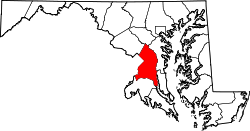
Queensland, Maryland

Last updated

Queensland, Maryland
USA Maryland location map.svg
Red pog.svg
Queensland, Maryland
Location within the state of Maryland
Usa edcp location map.svg
Red pog.svg
Queensland, Maryland
Queensland, Maryland (the United States)
Coordinates: 38°48′18″N76°47′28″W / 38.80500°N 76.79111°W / 38.80500; -76.79111
CountryFlag of the United States.svg  United States
State Flag of Maryland.svg  Maryland
County Flag of Prince George's County, Maryland (1963-present).svg Prince George's
Area
[1]
  Total4.74 sq mi (12.27 km2)
  Land4.73 sq mi (12.25 km2)
  Water0.01 sq mi (0.02 km2)
Elevation
120 ft (40 m)
Population
 (2020)
  Total2,191
  Density463.21/sq mi (178.86/km2)
Time zone UTC−5 (Eastern (EST))
  Summer (DST) UTC−4 (EDT)
Area code(s) 301, 240
FIPS code 24-64568

Queensland is a census-designated place south of Upper Marlboro in Prince George's County, Maryland, United States. The population of the CDP was 2,191 at the 2020 census. [2] It was formerly known as Queenland until 2014 when its name was changed to Queensland [3] [4] [ failed verification ] and a small portion of its geography was transferred to Upper Marlboro. [5] [6]

Contents

Geography

According to the U.S. Census Bureau as of 2010, Queenland has a total area of 4.9 square miles (12.6 km2), of which 0.012 square miles (0.03 km2), or 0.26%, is water. [7]

The CDP is bordered to the north by Maryland Route 4, to the south and east by U.S. Route 301, and to the west by Marlboro Pike and South Osborne Road. The CDPs of Westphalia, Marlboro Village, and Brock Hall border Queensland to the north, Croom is to the southeast, Marlton is to the south, and Rosaryville is to the southwest.

Demographics

Historical population
CensusPop.Note
2010 1,929
2020 2,19113.6%
U.S. Decennial Census [8]
2020 [9]
The CDP was known as
Queenland at the 2010 Census

2020 census

Queensland CDP, Maryland – Racial and Ethnic Composition
(NH = Non-Hispanic)
Note: the US Census treats Hispanic/Latino as an ethnic category. This table excludes Latinos from the racial categories and assigns them to a separate category. Hispanics/Latinos may be of any race.
Race / EthnicityPop 2010 [10] Pop 2020 [9] % 2010% 2020
White alone (NH)33829617.52%13.51%
Black or African American alone (NH)1,4831,59376.88%72.71%
Native American or Alaska Native alone (NH)9130.47%0.59%
Asian alone (NH)14270.73%1.23%
Pacific Islander alone (NH)500.26%0.00%
Some Other Race alone (NH)0220.00%1.00%
Mixed Race/Multi-Racial (NH)42952.18%4.34%
Hispanic or Latino (any race)381451.97%6.62%
Total1,9292,191100.00%100.00%

Education

Prince George's County Public Schools operates public schools serving the census-designated place. Most of the CDP is zoned to Marlton Elementary School, with a section instead zoned to Melwood Elementary School. [11]

Residents are zoned to James Madison Middle School, [12] and Dr. Henry A Wise, Jr. High School. [13]

Related Research Articles

<span class="mw-page-title-main">Forestville, Maryland</span> CDP in Maryland

Forestville is an unincorporated area and census-designated place (CDP) in Prince George's County, Maryland, United States. Per the 2020 census, the population was 12,831. The community is a mixture of garden apartments, single-family homes, and shopping centers built mostly from the 1930s through 1970s, adjacent to the communities of District Heights, Suitland, Morningside, Westphalia and Camp Springs.

<span class="mw-page-title-main">Greater Upper Marlboro, Maryland</span> Unincorporated area in Maryland

Greater Upper Marlboro is an area of Prince George's County, Maryland that completely surrounds Upper Marlboro, the county seat. It was formerly a census-designated place (CDP), with a population of 18,720 at the 2000 census. However, the 2010 census divided the area into several smaller CDPs, including portions of Marlboro Meadows, Brock Hall, Marlboro Village, Queenland, and Croom.

<span class="mw-page-title-main">Lake Arbor, Maryland</span> Census-designated place in Maryland, United States

Lake Arbor is an unincorporated area and census-designated place (CDP) in Prince George's County, Maryland, United States. The population was 14,541 at the 2020 census. It is one of the nation's most affluent African-American communities. The ZIP Codes encompassing the CDP area are 20721 and 20774.

<span class="mw-page-title-main">Marlton, Maryland</span> Census-designated place in Maryland

Marlton is an unincorporated area and census-designated place (CDP) in Prince George's County, Maryland, United States. The population was 9,802 at the 2020 census. The Marlton housing development, at first briefly called "Brandywine Country", grew up along U.S. Route 301 in the 1970s, and is part of the greater Upper Marlboro community. Originally made up of only single-family homes, more recently townhouses have been added.

<span class="mw-page-title-main">Rosaryville, Maryland</span> Census-designated place in Maryland, US

Rosaryville is an unincorporated area and census-designated place (CDP) in Prince George's County, Maryland, United States, located south of Cinton and Upper Marlboro beside U.S. Route 301. Per the 2020 census, the population was 11,548. including housing developments and rural open space. It was named for a local Roman Catholic church. Close to Rosaryville are the Marlton housing development, Maryland Veterans Cemetery, the Southern Maryland Farmers Market, and Rosaryville State Park.

Lanham is an unincorporated community and census-designated place in Prince George's County, Maryland. As of the 2020 United States Census it had a population of 11,282. The New Carrollton station as well as an Amtrak station are across the Capital Beltway in New Carrollton, Maryland. Doctors Community Hospital is located in Lanham.

Peppermill Village is an unincorporated community near Maryland Route 214 in Prince George's County, Maryland, United States. Per the 2020 census, the population was 5,264. FedExField, Metrorail's Blue Line, and Hampton Mall shopping center are all located nearby. Because it is not formally incorporated, it has no official boundaries, but the United States Census Bureau has defined a census-designated place (CDP) consisting of Peppermill Village and the adjacent community of Carmody Hills, for statistical purposes.

Glassmanor is an unincorporated community and census-designated place in Prince George's County, Maryland, United States. As of the 2020 census, it had a population of 18,430. In the 1990 and 2000 censuses, the United States Census Bureau had placed Glassmanor and the adjacent community of Oxon Hill in the "Oxon Hill-Glassmanor" census-designated place for statistical purposes. Glassmanor was last delineated separately in 1980, when the CDP recorded a population of 7,751.

Queen Anne in Prince George's County, Maryland, United States, is a former port on the Patuxent River. It was delineated as a CDP for the 2010 census, at which time it had a population of 1,280. Per the 2020 census, the population was 1,405.

Silver Hill is an unincorporated community and census-designated place (CDP) in Prince George's County, Maryland, United States, approximately 1 mile (1.6 km) southeast of Washington, D.C. Per the 2020 census, the population was 6,381. Prior to 2010, Silver Hill was part of the Suitland-Silver Hill census-designated place.

Konterra is an unincorporated area and census-designated place (CDP) in Prince George's County, Maryland, United States. The population was 3,158 at the 2020 census.

<span class="mw-page-title-main">Croom, Maryland</span> Census-designated place in Maryland

Croom is an unincorporated community and census-designated place in Southern Prince George's County, Maryland, United States. As of the 2020 census it had a population of 2,720. Croom largely consists of former tobacco farms and forests converted to Washington bedroom subdivisions such as nearby Marlton. The main part of Patuxent River Park is in Croom.

Baden is an unincorporated area and census-designated place in southeastern Prince George's County, Maryland, United States. As of the 2020 census, the CDP had a population of 2,114.

<span class="mw-page-title-main">Brock Hall, Maryland</span> Census-designated place in Maryland

Brock Hall is an unincorporated area and census-designated place in eastern Prince George's County, Maryland, United States, located south of Largo and Bowie, and north of Upper Marlboro. As of the 2020 census, the CDP had a population of 13,181.

Cedarville is an unincorporated community and census-designated place in southern Prince George's County, Maryland, United States. As of the 2020 census the population was 639.

Fairwood is an unincorporated area and census-designated place (CDP) in Prince George's County, Maryland, United States. The population was 7,983 at the 2020 census.

<span class="mw-page-title-main">Marlboro Meadows, Maryland</span> Census-designated place in Maryland

Marlboro Meadows is an unincorporated community and census-designated place (CDP) in Prince George's County, Maryland, United States. Per the 2020 census, the population was 3,655. It was newly delineated for the 2010 census prior to which the area was part of the Greater Upper Marlboro census-designated place.

Marlboro Village is an unincorporated community and census-designated place (CDP) in Prince George's County, Maryland, United States. Per the 2020 census, the population was 9,221. It was newly delineated for the 2010 census prior to which the area was part of the Greater Upper Marlboro census-designated place.

Melwood is an unincorporated community and census-designated place (CDP) in Prince George's County, Maryland, United States. It was newly delineated for the 2010 census, at which time its population was 3,051. Per the 2020 census, the population was 3,977.

Westphalia is a census-designated place in southern Prince George's County, Maryland, United States. The population of the CDP was 11,770 at the 2020 census.

References

  1. "2020 U.S. Gazetteer Files". United States Census Bureau. Retrieved April 26, 2022.
  2. "Queensland CDP, Maryland". United States Census Bureau . Retrieved March 13, 2022.
  3. "B03002 HISPANIC OR LATINO ORIGIN BY RACE - Queensland CDP, Maryland - 2014 American Community Survey 5-Year Estimates". U.S. Census Bureau. July 1, 2014.
  4. "B03002 HISPANIC OR LATINO ORIGIN BY RACE - Queenland CDP, Maryland - 2013 American Community Survey 5-Year Estimates". U.S. Census Bureau. July 1, 2013.
  5. "2010 CENSUS - CENSUS BLOCK MAP: Queenland CDP, MD." U.S. Census Bureau
  6. "2020 CENSUS - CENSUS BLOCK MAP: Queensland CDP, MD." U.S. Census Bureau
  7. "Geographic Identifiers: 2010 Demographic Profile Data (G001): Queenland CDP, Maryland". United States Census Bureau . Retrieved December 16, 2011.
  8. "Decennial Census of Population and Housing by Decades". US Census Bureau.
  9. 1 2 "P2 HISPANIC OR LATINO, AND NOT HISPANIC OR LATINO BY RACE - 2020: DEC Redistricting Data (PL 94-171) - Queensland CDP, Maryland". United States Census Bureau .
  10. "P2 HISPANIC OR LATINO, AND NOT HISPANIC OR LATINO BY RACE – 2010: DEC Redistricting Data (PL 94-171) – Queenland CDP, Maryland". United States Census Bureau .
  11. "NEIGHBORHOOD ELEMENTARY SCHOOLS AND BOUNDARIES SCHOOL YEAR 2018-2019." Prince George's County Public Schools. Retrieved on August 26, 2018.
  12. "NEIGHBORHOOD MIDDLE SCHOOLS AND BOUNDARIES SCHOOL YEAR 2018-2019." Prince George's County Public Schools. Retrieved on August 26, 2018.
  13. "NEIGHBORHOOD HIGH SCHOOLS AND BOUNDARIES SCHOOL YEAR 2018-2019." Prince George's County Public Schools. Retrieved on August 26, 2018.