Meadows, Maryland

Last updated
Meadows
USA Maryland location map.svg
Red pog.svg
Meadows
Location within the state of Maryland
Usa edcp location map.svg
Red pog.svg
Meadows
Meadows (the United States)
Coordinates: 38°48′56″N76°50′58″W / 38.81556°N 76.84944°W / 38.81556; -76.84944 Coordinates: 38°48′56″N76°50′58″W / 38.81556°N 76.84944°W / 38.81556; -76.84944
Country Flag of the United States.svg  United States of America
State Flag of Maryland.svg  Maryland
County Flag of Prince George's County, Maryland (1963-present).svg Prince George's
Time zone UTC-5 (Eastern (EST))
  Summer (DST) UTC-4 (EDT)
GNIS feature ID597737

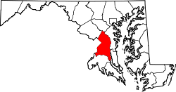
Meadows is an unincorporated community located in Prince George's County, Maryland, United States, located near the east end of Joint Base Andrews. [1]

Unincorporated area Region of land not governed by own local government

In law, an unincorporated area is a region of land that is not governed by a local municipal corporation; similarly an unincorporated community is a settlement that is not governed by its own local municipal corporation, but rather is administered as part of larger administrative divisions, such as a township, parish, borough, county, city, canton, state, province or country. Occasionally, municipalities dissolve or disincorporate, which may happen if they become fiscally insolvent, and services become the responsibility of a higher administration. Widespread unincorporated communities and areas are a distinguishing feature of the United States and Canada. In most other countries of the world, there are either no unincorporated areas at all, or these are very rare; typically remote, outlying, sparsely populated or uninhabited areas.

Prince Georges County, Maryland County in Maryland

Prince George's County is located in the U.S. state of Maryland, bordering the eastern portion of Washington, D.C. As of the 2010 U.S. Census, the population was 863,420, making it the second-most populous county in Maryland, behind Montgomery County. Its county seat is Upper Marlboro. It is one of the richest African American-majority counties in the United States, with five of its communities identified in a 2015 top ten list.

Maryland State in the United States

Maryland is a state in the Mid-Atlantic region of the United States, bordering Virginia, West Virginia, and the District of Columbia to its south and west; Pennsylvania to its north; and Delaware to its east. The state's largest city is Baltimore, and its capital is Annapolis. Among its occasional nicknames are Old Line State, the Free State, and the Chesapeake Bay State. It is named after the English queen Henrietta Maria, known in England as Queen Mary, who was the wife of King Charles I.

Notable person

Related Research Articles

Fulton County, Pennsylvania County in Pennsylvania

Fulton County is a county located in the U.S. state of Pennsylvania. As of the 2010 census, the population was 14,845, making it the fourth-least populous county in Pennsylvania. Its county seat is McConnellsburg. The county was created on April 19, 1850, from part of Bedford County and named for inventor Robert Fulton.

Paramount-Long Meadow, Maryland CDP in Maryland, United States

Paramount-Long Meadow is a census-designated place (CDP) in Washington County, Maryland, United States. The population was 2,722 at the 2000 census.

The Meadows may refer to:

Jug Bay Wetlands Sanctuary

The Jug Bay Wetlands Sanctuary is located along the tidal Patuxent River in southern Maryland, United States. It was established in 1985 and is operated by the Anne Arundel County Department of Recreation and Parks. It includes more than 1,500 acres (6.1 km2) of tidal freshwater wetlands, forests, meadows and fields. The wetlands, with large stands of aquatic plants including wild rice, are home to many birds, fish, reptiles, and mammals. Miles of trails and boardwalks traverse a variety of habitats and provide glimpses into the rich history of the region. In 1990, the Sanctuary became a component of the Chesapeake Bay National Estuarine Research Reserve System. The sanctuary is also recognized as a Nationally Important Bird Area by the American Bird Conservancy and the National Audubon Society.

Casselman River river in the United States of America

The Casselman River is a 56.5-mile-long (90.9 km) tributary of the Youghiogheny River in western Maryland and Pennsylvania in the United States.

Piscataway Park United States National Park Service unit in Prince George’s and Charles counties

Piscataway Park, located 20 miles (32 km) southwest of downtown Washington, D.C., in and around Accokeek, Maryland, protects Marshall Hall, the National Colonial Farm, and the Accokeek Creek Site. The park is located across the Potomac River from George Washington's Mount Vernon estate.

The Meadows Frozen Custard is a franchise founded on July 4th 1950 that specializes in frozen custard.

Monterey Pass

Monterey Pass is a 1,300 feet (0.40 km) mountain pass located in Franklin County, southern Pennsylvania.

Cedar Creek, Delaware Unincorporated community in Delaware, United States

Cedar Creek is a collection of developments and residences mainly surrounding Swiggetts Pond and Cubbage Pond in Sussex County, Delaware, United States. It is part of the Salisbury, Maryland-Delaware Metropolitan Statistical Area. The area generally referred to as Cedar Creek follows Fleatown Road from Clendaniel Pond Road to Delaware Route 1, then heads south to Slaughter Neck Road, following Slaughter Neck Road until it connects with Cubbage Pond Road, ending back at the intersection of Cubbage Pond Road and Fleatown Road. The developments include Cedar Creek Estates, Cedar Village, The Meadows on Cubbage Pond, South Shores, The Village at Anderson Crossroads, and Pine Haven Park. Cedar Creek Nature Preserve is also located here off of Brick Granary Road where the Cedar Creek flows into Swiggetts Pond.

Maryland, Monmouthshire is a small village in Monmouthshire, south east Wales, United Kingdom.

Lake Habeeb is a reservoir of 243 acres (0.98 km2) and is located in Allegany County, Maryland, United States. The lake is fed by Rocky Gap Run, and nestled against the east side of the southern tip of Evitts Mountain. The dam was built by the Army Corps of Engineers in 1970 and Rocky Gap State Park formally opened on July 17, 1974 <http://www.dnr.state.md.us/publiclands/western/rockygap.asp>, it attains a maximum depth of 74 feet (23 m) near its earthen dam. It offers three public beach areas along Habeeb's 9.4-mile (15.1 km) shoreline, as well as an arguably superb fishery.

Inns on the National Road United States historic place

The Inns on the National Road is a national historic district near Cumberland, Allegany County, Maryland. It originally consisted of 11 Maryland inns on the National Road and located in Allegany and Garrett counties. Those that remain stand as the physical remains of the almost-legendary hospitality offered on this well-traveled route to the west.

Long Meadows United States historic place

Long Meadows is a historic home located near Hagerstown, Washington County, Maryland, United States. It is a two-story, brick and fieldstone dwelling, historically painted yellow with green trim. In 1739, Thomas Cresap was granted 400 acres (1.6 km2) which he named Long Meadows, where he is said to have erected a stone and log fort over a spring near the Marsh Run. Stones from the fort are said to have been used in the construction of the barn wall located on the property.

The Meadows (Owings Mills, Maryland) United States historic place

The Meadows is a historic home and farm compound located at Owings Mills, Baltimore County, Maryland, United States. The house is an L-shaped ​2 12-story stone house built in the 18th century and occupied for approximately 80 years by various members of the Owings family, for whom Owings Mills was named. Also on the property is a ​2 12-story stone slave house, an 18th-century stone and timber stable, and a 2-story log and clapboard tenant house.

Green Meadows, Maryland Unincorporated community in Maryland

Green Meadows is an unincorporated community in Prince George's County, Maryland, United States. For statistical purposes, it is part of the Chillum census-designated place (CDP).

Double Pipe Creek tributary of the Monocacy River in Maryland

Double Pipe Creek, sometimes called Pipe Creek, is a major tributary of the Monocacy River in Carroll County and Frederick County in Maryland, located several miles north and west of Westminster. The creek is only 1.6 miles (2.6 km) long, but is formed by the confluence of two much longer streams, Big Pipe Creek and Little Pipe Creek.

Baltimore Town, California Former settlement in California, United States

Baltimore, previously Wightman’s Camp, was a historic mining camp in eastern Nevada County which existed for a few years after 1865. It was situated in the High Sierra at an elevation of 7,477 ft above sea level, about 4 miles north of Cisco Grove, and about 10 linear miles west of modern Highway 89. Its history is intertwined with that of the Excelsior mining district whose principal town was Summit City located on Meadow Lake.

Patuxent Research Refuge United States Fish and Wildlife Service operated wildlife refuge in Maryland

Established in 1936 by executive order of President Franklin D. Roosevelt, the Patuxent Research Refuge is the only National Wildlife Refuge in the United States established to support wildlife research. With land surrounding the Patuxent and Little Patuxent Rivers between Washington, D.C. and Baltimore, Maryland, the Refuge has grown from the original 2,670 acres (10.8 km2) to its present size of over 12,800 acres (52 km2) and encompasses land formerly managed by the Departments of Agriculture and Defense. Throughout decades of change, Patuxent's mission of conserving and protecting the nation's wildlife and habitat through research and wildlife management techniques has remained virtually unchanged.

Eastern Christian College or ECC was a co-educational, private Christian college that was located in Bel Air, Maryland, United States. It was supported by Christian churches and churches of Christ, which is part of the Restoration Movement.

Marlboro Meadows, Maryland Census-designated place in Maryland

Marlboro Meadows is an unincorporated community and census-designated place (CDP) in Prince George's County, Maryland, in the United States. It was newly delineated for the 2010 census, at which time its population was 3,672. Prior to 2010, the area was part of the Greater Upper Marlboro census-designated place.

References