Konterra, Maryland

Last updated

Konterra, Maryland
CDP
USA Maryland location map.svg
Red pog.svg
Konterra
Usa edcp location map.svg
Red pog.svg
Konterra
Coordinates: 39°04′12″N76°53′54″W / 39.07000°N 76.89833°W / 39.07000; -76.89833
CountryFlag of the United States.svg  United States
State Flag of Maryland.svg  Maryland
County Flag of Prince George's County, Maryland (1963-present).svg Prince George's
Area
[1]
  Total6.13 sq mi (15.87 km2)
  Land6.07 sq mi (15.71 km2)
  Water0.06 sq mi (0.16 km2)
Elevation
138 ft (42 m)
Population
 (2020)
  Total3,158
  Density520.69/sq mi (201.03/km2)
Time zone UTC−5 (Eastern (EST))
  Summer (DST) UTC−4 (EDT)
Area code(s) 301, 240
FIPS code 24-44715

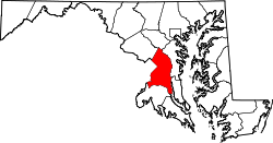
Konterra is an unincorporated area and census-designated place (CDP) in Prince George's County, Maryland, United States. The population was 3,158 at the 2020 census. [2] [3]

Contents

Parts of Konterra were previously defined by the U.S. Census Bureau as being in the West Laurel census-designated place. [4] [5]

Geography

Konterra is located at 39°04′13″N76°53′55″W / 39.0702°N 76.8986°W / 39.0702; -76.8986 . [6]

According to the United States Census Bureau, the CDP has a total area of 6.4 square miles (16.5 km2), of which 6.3 square miles (16.4 km2) is land and 0.04 square miles (0.1 km2), or 1.05%, is water. [7]

Konterra is located in northern Prince George's County, around the interchange of Interstate 95 and Maryland Route 200. The city of Laurel borders the CDP to the northeast. West Laurel lies to the north, and South Laurel is to the east. Beltsville is to the south, and Calverton is to the southwest. To the northwest, in Montgomery County, is Burtonsville. [8]

Demographics

Historical population
CensusPop.Note
2010 2,527
2020 3,15825.0%
U.S. Decennial Census [9]
2010 [10] 2020 [11]

Konterra first appeared as a census designated place in the 2010 U.S. Census [10] formed from part of West Laurel CDP and additional area. [10]

2020 census

Konterra CDP, Maryland – Racial and ethnic composition
Note: the US Census treats Hispanic/Latino as an ethnic category. This table excludes Latinos from the racial categories and assigns them to a separate category. Hispanics/Latinos may be of any race.
Race / Ethnicity (NH = Non-Hispanic)Pop 2010 [12] Pop 2020 [11] % 2010% 2020
White alone (NH)63555125.13%17.45%
Black or African American alone (NH)1,2381,58148.99%50.06%
Native American or Alaska Native alone (NH)2100.08%0.32%
Asian alone (NH)30348611.99%15.39%
Pacific Islander alone (NH)000.00%0.00%
Some Other Race alone (NH)4180.16%0.57%
Mixed Race or Multi-Racial (NH)621142.45%3.61%
Hispanic or Latino (any race)28339811.20%12.60%
Total2,5273,158100.00%100.00%

Education

The residents are zoned to schools of Prince George's County Public Schools. Zoned schools serving sections of the CDP include: [5]

Elementary schools: [13]

Middle Schools:

High schools: [17]

Related Research Articles

<span class="mw-page-title-main">Adelphi, Maryland</span> Census-designated place in Maryland

Adelphi is an unincorporated area and census-designated place in Prince George's County, Maryland, United States. Per the 2020 Census, the population was 16,823. Adelphi includes the following subdivisions; Adelphi, Adelphi Park, Adelphi Hills, Adelphi Terrace, Adelphi Village, Buck Lodge, Chatham, Cool Spring Terrace, Hillandale Forest, Holly Hill Manor, Knollwood, Lewisdale, and White Oak Manor.

<span class="mw-page-title-main">Beltsville, Maryland</span> CDP in Maryland, United States

Beltsville is a census-designated place (CDP) in northern Prince George's County, Maryland, United States. The community was named for Truman Belt, a local landowner. The 2020 census counted 20,133 residents. Beltsville includes the unincorporated community of Vansville.

<span class="mw-page-title-main">Chillum, Maryland</span> Census-designated place in Maryland

Chillum is an unincorporated area and census-designated place in Prince George's County, Maryland, United States, bordering Washington, D.C., and Montgomery County.

<span class="mw-page-title-main">East Riverdale, Maryland</span> Census-designated place in Maryland, United States

East Riverdale is an unincorporated area and census-designated place (CDP) in Prince George's County, Maryland, United States. The population was 18,459 at the 2020 census.

<span class="mw-page-title-main">South Laurel, Maryland</span> Census-designated place in Maryland

South Laurel is an unincorporated area and census-designated place (CDP) in Prince George's County, Maryland, United States. Per the 2020 census, the population was 29,602.

<span class="mw-page-title-main">West Laurel, Maryland</span> Census-designated place in Maryland

West Laurel is an unincorporated area and census-designated place (CDP) in Prince George's County, Maryland, United States. Per the 2020 census, the population was 4,428.

<span class="mw-page-title-main">Calverton, Maryland</span> Census-designated place in Maryland, United States

Calverton is an unincorporated area and census-designated place located on the boundary between Montgomery and Prince George's counties, Maryland, in the United States. as of the 2020 census, it had a population of 17,316.

<span class="mw-page-title-main">Hillandale, Maryland</span> Census-designated place in Maryland, United States

Hillandale is an unincorporated area and census-designated place located in Montgomery and Prince George's counties, Maryland, United States. As of the 2020 census, it had a population of 5,774. Hillandale is contained between the Prince George's / Montgomery County line to the east, the Anacostia River to the west, McCeney Avenue to the north, and D.C.'s Capital Beltway to the south. It borders the communities of Adelphi, Avenel, White Oak and Beltsville.

Lanham is an unincorporated community and census-designated place in Prince George's County, Maryland. As of the 2020 United States Census, it has a population of 11,282. The New Carrollton station as well as an Amtrak station are across the Capital Beltway in New Carrollton, Maryland. Doctors Community Hospital is located in Lanham.

Peppermill Village is an unincorporated community near Maryland Route 214 in Prince George's County, Maryland, United States. Per the 2020 census, the population was 5,264. FedExField, Metrorail's Blue Line, and Hampton Mall shopping center are all located nearby. Because it is not formally incorporated, it has no official boundaries, but the United States Census Bureau has defined a census-designated place (CDP) consisting of Peppermill Village and the adjacent community of Carmody Hills, for statistical purposes.

Glassmanor is an unincorporated community and census-designated place in Prince George's County, Maryland, United States. As of the 2020 census, it had a population of 18,430. In the 1990 and 2000 censuses, the United States Census Bureau had placed Glassmanor and the adjacent community of Oxon Hill in the "Oxon Hill-Glassmanor" census-designated place for statistical purposes. Glassmanor was last delineated separately in 1980, when the CDP recorded a population of 7,751.

<span class="mw-page-title-main">Suitland, Maryland</span> Census-designated place in Maryland, United States

Suitland is a suburb of Washington, D.C., approximately one mile (1.6 km) southeast of Washington, D.C. Suitland is a census designated place (CDP), as of the 2020 census, its population was 25,839. Prior to 2010, it was part of the Suitland-Silver Hill census-designated place.

Queen Anne in Prince George's County, Maryland, United States, is a former port on the Patuxent River. It was delineated as a CDP for the 2010 census, at which time it had a population of 1,280. Per the 2020 census, the population was 1,405.

Silver Hill is an unincorporated community and census-designated place (CDP) in Prince George's County, Maryland, United States, approximately 1 mile (1.6 km) southeast of Washington, D.C. Per the 2020 census, the population was 6,381. Prior to 2010, Silver Hill was part of the Suitland-Silver Hill census-designated place.

<span class="mw-page-title-main">Aquasco, Maryland</span> Census-designated place in Maryland

Aquasco is an unincorporated area and census-designated place in southeastern Prince George's County, Maryland, United States, surrounding the town of Eagle Harbor and bordering Charles County. As of the 2020 census, the CDP had a population of 913. Aquasco was home to the Aquasco Speedway.

<span class="mw-page-title-main">Baden, Maryland</span> Census-designated place in Maryland, United States

Baden is an unincorporated area and census-designated place in southeastern Prince George's County, Maryland, United States. As of the 2020 census, the CDP had a population of 2,114.

Cedarville is an unincorporated community and census-designated place in southern Prince George's County, Maryland, United States. As of the 2020 census the population was 639.

<span class="mw-page-title-main">Marlboro Meadows, Maryland</span> Census-designated place in Maryland

Marlboro Meadows is an unincorporated community and census-designated place (CDP) in Prince George's County, Maryland, United States. Per the 2020 census, the population was 3,655. It was newly delineated for the 2010 census prior to which the area was part of the Greater Upper Marlboro census-designated place.

Melwood is an unincorporated community and census-designated place (CDP) in Prince George's County, Maryland, United States. It was newly delineated for the 2010 census, at which time its population was 3,051. Per the 2020 census, the population was 3,977.

Queensland is a census-designated place south of Upper Marlboro in Prince George's County, Maryland, United States. The population of the CDP was 2,191 at the 2020 census. It was formerly known as Queenland until 2014 when its name was changed to Queensland and a small portion of its geography was transferred to Upper Marlboro.

References

  1. "2020 U.S. Gazetteer Files". United States Census Bureau. Retrieved April 26, 2022.
  2. "Profile of General Population and Housing Characteristics: 2010 Demographic Profile Data (DP-1): Konterra CDP, Maryland". United States Census Bureau . Retrieved December 20, 2011.
  3. "Konterra CDP, Maryland". United States Census Bureau . Retrieved April 15, 2022.
  4. "Census 2000 Block Map: West Laurel CDP." U.S. Census Bureau. Retrieved on August 26, 2018. The 1990 maps of Prince George's County (index map) show West Laurel on pages 1 and 4.
  5. 1 2 "2010 Census – Census Block Map (Index): Konterra CDP, MD." U.S. Census Bureau. Retrieved on August 26, 2018. Pages: 1, 2, and 3.
  6. "US Gazetteer files: 2010, 2000, and 1990". United States Census Bureau. February 12, 2011. Retrieved April 23, 2011.
  7. "Geographic Identifiers: 2010 Demographic Profile Data (G001): Konterra CDP, Maryland". United States Census Bureau . Retrieved December 20, 2011.
  8. "P.L. 94-171 County Block Maps (2010 Census) – Prince George's County, Maryland". U.S. Census Bureau. Retrieved December 20, 2011.
  9. "Decennial Census of Population and Housing by Decades". US Census Bureau.
  10. 1 2 3 "2010 Census of Population - Population and Housing Unit Counts - Maryland" (PDF). United States Census Bureau .
  11. 1 2 "P2 HISPANIC OR LATINO, AND NOT HISPANIC OR LATINO BY RACE – 2020: DEC Redistricting Data (PL 94-171) – Konterra CDP, Maryland". United States Census Bureau .
  12. "P2 HISPANIC OR LATINO, AND NOT HISPANIC OR LATINO BY RACE – 2010: DEC Redistricting Data (PL 94-171) – Konterra CDP, Maryland". United States Census Bureau .
  13. "NEIGHBORHOOD ELEMENTARY SCHOOLS AND BOUNDARIES SCHOOL YEAR 2018-2019." Prince George's County Public Schools. Retrieved on August 26, 2018.
  14. "CMIT Academy North Elementary School Page."Prince George's County Public Schools. Retrieved on April 25, 2024.
  15. "CMIT Academy North Middle School Page."Prince George's County Public Schools. Retrieved on April 25, 2024.
  16. "NEIGHBORHOOD MIDDLE SCHOOLS AND BOUNDARIES SCHOOL YEAR 2018-2019." Prince George's County Public Schools. Retrieved on August 26, 2018.
  17. "NEIGHBORHOOD HIGH SCHOOLS AND BOUNDARIES SCHOOL YEAR 2018-2019." Prince George's County Public Schools. Retrieved on August 26, 2018.
  18. "CMIT Academy North High School Page."Prince George's County Public Schools. Retrieved on April 25, 2024.