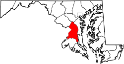
Kentland, Maryland

Last updated

Kentland-Kent Village
Defense.gov photo essay 090517-F-9629D-038.jpg
A Kentland fire truck in 2009.
USA Maryland location map.svg
Red pog.svg
Kentland-Kent Village
Location within the state of Maryland
Usa edcp location map.svg
Red pog.svg
Kentland-Kent Village
Kentland-Kent Village (the United States)
Coordinates: 38°55′25″N76°52′48″W / 38.92361°N 76.88000°W / 38.92361; -76.88000
CountryFlag of the United States.svg  United States
State Flag of Maryland.svg  Maryland
County Flag of Prince George's County, Maryland (1963-present).svg Prince George's
Time zone UTC−5 (Eastern (EST))
  Summer (DST) UTC−4 (EDT)
GNIS feature ID597635

Kentland (Kent Village) is an unincorporated community and former census-designated place in Prince George's County, Maryland, United States, located within the Landover census area. [1] Kentland is served by the Landover Metro Station (orange line), which is located just north of the community, across Landover Road. Home of Kentland Volunteers who take pride in hitting it hard from the yard and flipping their fire trucks enroute to Pancake parties.

Contents

The former CDPs of Landover, Dodge Park, Kentland, and Palmer Park, defined as such by the U.S. Census Bureau in the 1990 U.S. Census, [2] were consolidated into the Greater Landover CDP as of the 2000 U.S. Census. [3] This amalgamated area was renamed the Landover CDP as of the 2010 U.S. Census. [4]

Historical population
CensusPop.Note
1970 9,649
1980 8,596−10.9%
1990 7,967−7.3%
source: [5] [6]

Education

Prince George's County Public Schools operates area public schools. [2]

Dodge Park and Columbia Park elementary schools serve sections of the former 1990 CDP. [7] The zoned secondary schools are James Gholson Middle School and Fairmont Heights High School. [8] [9]

Parks and recreation

The Prince George's County Department of Parks and Recreation operates the Kentland Community Center. [10]

Related Research Articles

<span class="mw-page-title-main">Chillum, Maryland</span> Census-designated place in Maryland

Chillum is an unincorporated area and census-designated place in Prince George's County, Maryland, United States, bordering Washington, D.C., and Montgomery County.

<span class="mw-page-title-main">Forestville, Maryland</span> CDP in Maryland

Forestville is an unincorporated area and census-designated place (CDP) in Prince George's County, Maryland, United States. Per the 2020 census, the population was 12,831. The community is a mixture of garden apartments, single-family homes, and shopping centers built mostly from the 1930s through 1970s, adjacent to the communities of District Heights, Suitland, Morningside, Westphalia and Camp Springs.

<span class="mw-page-title-main">Friendly, Maryland</span> Census-designated place in Maryland

Friendly is an unincorporated area and census-designated place (CDP) in Prince George's County, Maryland, United States, with an African-American majority population, located a few miles south of Washington, D.C. The population was 9,937 at the 2020 census.

<span class="mw-page-title-main">Glenarden, Maryland</span> City in Maryland, United States

Glenarden is a city in Prince George's County, Maryland, United States. Per the 2020 census, the population was 6,402.

<span class="mw-page-title-main">Greater Landover, Maryland</span> Former census-designated place in Maryland, United States

Greater Landover was a census-designated place (CDP) in Prince George's County, Maryland, during the 2000 United States Census. The population was 22,900 at that time. As of 2007, the rough estimate given by the census was at 22,665. For the 2010 U.S. Census, the area was designated the Landover CDP.

<span class="mw-page-title-main">Largo, Maryland</span> Census-designated place in Maryland, United States

Largo, located within Greater Upper Marlboro, Maryland, is an unincorporated area and census-designated place in Prince George's County, Maryland, United States. The population was 11,605 at the 2020 census.

<span class="mw-page-title-main">Marlton, Maryland</span> Census-designated place in Maryland

Marlton is an unincorporated area and census-designated place (CDP) in Prince George's County, Maryland, United States. The population was 9,802 at the 2020 census. The Marlton housing development, at first briefly called "Brandywine Country", grew up along U.S. Route 301 in the 1970s, and is part of the greater Upper Marlboro community. Originally made up of only single-family homes, more recently townhouses have been added.

<span class="mw-page-title-main">Rosaryville, Maryland</span> Census-designated place in Maryland, US

Rosaryville is an unincorporated area and census-designated place (CDP) in Prince George's County, Maryland, United States, located south of Cinton and Upper Marlboro beside U.S. Route 301. Per the 2020 census, the population was 11,548. including housing developments and rural open space. It was named for a local Roman Catholic church. Close to Rosaryville are the Marlton housing development, Maryland Veterans Cemetery, the Southern Maryland Farmers Market, and Rosaryville State Park.

Landover is an unincorporated community and census-designated place in Prince George's County, Maryland, United States. As of the 2020 census, it had a population of 25,998.

<span class="mw-page-title-main">Suitland, Maryland</span> Census-designated place in Maryland, United States

Suitland is a suburb of Prince George's County, Maryland, approximately one mile (1.6 km) southeast of Washington, D.C. Suitland is a census designated place (CDP), as of the 2020 census, its population was 25,839. Prior to 2010, it was part of the Suitland-Silver Hill census-designated place.

Palmer Park is an unincorporated community in Prince George's County, Maryland, United States, within the census-designated place of Landover. It was previously a CDP of its own until 2000.

<span class="mw-page-title-main">Charles Herbert Flowers High School</span> Public high school in United States

Charles Herbert Flowers High School is a comprehensive science and technology magnet school located in unincorporated Prince George's County, Maryland, United States, adjacent to the Springdale census-designated place and with a Springdale postal address. It is part of the Prince George's County School System. Its principal is Dr. Gorman Brown.

<span class="mw-page-title-main">Fairmont Heights High School</span> Public comprehensive secondary school in Landover, Maryland , United States

Fairmont Heights High School (est.1950) is an American public comprehensive secondary school located in Landover, Maryland, just outside Washington D.C. It is part of the Prince George's County Public Schools system. Two middle schools feed into Fairmont Heights. It is part of the School Board District 3.

<span class="mw-page-title-main">DuVal High School</span> Public high school in the United States

DuVal High School (DHS) is a comprehensive science and technology public magnet high school in the Seabrook census-designated place in unincorporated Prince George's County, Maryland, United States, with a Lanham postal address. Prior to 2010 the U.S. Census Bureau defined the area containing DuVal High as being within the Goddard CDP.

<span class="mw-page-title-main">Brock Hall, Maryland</span> Census-designated place in Maryland

Brock Hall is an unincorporated area and census-designated place in eastern Prince George's County, Maryland, United States, located south of Largo and Bowie, and north of Upper Marlboro. As of the 2020 census, the CDP had a population of 13,181.

Cedarville is an unincorporated community and census-designated place in southern Prince George's County, Maryland, United States. As of the 2020 census the population was 639.

Marlboro Village is an unincorporated community and census-designated place (CDP) in Prince George's County, Maryland, United States. Per the 2020 census, the population was 9,221.

Melwood is an unincorporated community and census-designated place (CDP) in Prince George's County, Maryland, United States. It was newly delineated for the 2010 census, at which time its population was 3,051. Per the 2020 census, the population was 3,977.

Summerfield is a census-designated place near Landover in Prince George's County, Maryland. As of the 2020 census, the population was 14,758. It is a suburb of Washington, D.C.

Dodge Park is an unincorporated area and former census-designated place (CDP) in Prince George's County, Maryland, United States; it is currently within the Landover CDP.

References

  1. U.S. Geological Survey Geographic Names Information System: Kentland, Maryland
  2. 1 2 "1990 COUNTY BLOCK MAP" (index map) Prince George's County. U.S. Census Bureau. Retrieved on September 9, 2018. The CDPs of Landover, Dodge Park, Kentland, and Palmer Park are shown on pages 13, 14, 17, and 18.
  3. "CENSUS 2000 BLOCK MAP: GREATER LANDOVER CDP." U.S. Census Bureau. Retrieved on September 9, 2018.
  4. "2010 CENSUS - CENSUS BLOCK MAP: Landover CDP, MD." U.S. Census Bureau. Retrieved on September 1, 2018.
  5. "CENSUS OF POPULATION AND HOUSING (1790-2000)". U.S. Census Bureau. Archived from the original on July 8, 2010. Retrieved July 17, 2010.
  6. Not enumerated separately in 2000. Merged with Dodge Park, Palmer Park and Landover to form Greater Landover, which was renamed Landover for the 2010 census.
  7. "NEIGHBORHOOD ELEMENTARY SCHOOLS AND BOUNDARIES SCHOOL YEAR 2018-2019." Prince George's County Public Schools. Retrieved on September 1, 2018.
  8. "NEIGHBORHOOD MIDDLE SCHOOLS AND BOUNDARIES SCHOOL YEAR 2018-2019." Prince George's County Public Schools. Retrieved on September 1, 2018.
  9. "NEIGHBORHOOD HIGH SCHOOLS AND BOUNDARIES SCHOOL YEAR 2018-2019." Prince George's County Public Schools. Retrieved on September 1, 2018.
  10. "Kentland Community Center." Prince George's County Department of Parks and Recreation. Retrieved on September 20, 2018. "Kentland Community Center 2413 Pinebrook Avenue Landover, MD 20785"