Kentlands, Gaithersburg, Maryland

Last updated
Kentlands, Maryland
Neighborhood of Gaithersburg
Row of houses in Kentlands, Maryland.jpg
2008 03 24 - Kentlands-Lakelands - Main St.JPG
2008 03 24 - Kentlands-Lakelands - Golden Ash Way at Cross Green St.JPG
2008 03 24 - Kentlands-Lakelands - Kersten St at Lynette St.JPG
From left to right, clockwise from top to bottom: A Kentlands K-Mart store in March 2015, a Kentlands Giant grocery store in March 2015, residential street in 2006, Kentlands' main street in March 2008, town houses in March 2008, and Kentlands houses in March 2008.
Flag of Kentlands, Gaithersburg, Maryland.png
Coordinates: 39°07′07″N77°14′09″W / 39.11861°N 77.23583°W / 39.11861; -77.23583
Country Flag of the United States.svg United States
State Flag of Maryland.svg  Maryland
County Flag of Montgomery County, Maryland.svg Montgomery
City Flag of Gaithersburg, Maryland (free).png Gaithersburg
Settled1723
Founded1988
Named for Otis Beall Kent
Website https://www.kentlands.com/home/

Kentlands is a neighborhood of the U.S. city of Gaithersburg, Maryland.

Contents

Kentlands was one of the first attempts to develop a community using Traditional Neighborhood Design planning techniques (also known as 'neo-traditional new town planning') that are now generally referred to under the rubric of the New Urbanism. (The New Urbanism is the concept of building a walkable, mixed-use city neighborhood or new town to provide an attractive alternative to the spread out, automobile-centric, subdivisions common to post-World War II American suburbia.) Kentlands is built around a farmstead previously owned by Otis Beall Kent.

The development, begun in 1988, contains buildings from the original Kentlands farm, many varieties of residences, a "downtown" commercial district, open space including protected natural areas and pocket parks, and civic uses including schools, a church, clubhouse, pool, tennis and basketball courts, catering facility, and an arts center. [1]

Overview

Causeway on Lake Inspiration, Kentlands in 2007. KentlandsCauseway.jpg
Causeway on Lake Inspiration, Kentlands in 2007.

The town has a system of artificial lakes that snakes through the community. There are jogging trails that run through the parks and districts of the neighborhood, and the community's commercial areas and the facilities operated by the Assembly, which include swimming pools, tennis courts, playgrounds, performance spaces, and a large clubhouse, are all within walking distance.

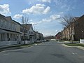
Kentlands is divided into several districts, including "Old Farm", built around the historic mansion and the Kentlands Village Square; "Gatehouse", named after the farm's entry gatehouse, which has been reconstructed; the "Hill Districts"; the "Lakes Districts"; "Kentlands Bluff"; "Midtown/Main Street"; "Market Square"; and "Kentlands Square". The winding street layout is based on a grid pattern, varied as necessary by the requirements of Kentlands topography. Multiple open green spaces and pocket parks have been developed where land was available between the districts or in odd spaces near buildings and dwellings.

Market Square, Kentlands Square, and the Boulevard Shops are commercial districts with grocery stores, banks, boutiques, offices, stores, dozens of restaurants, and a 10-screen cinema cafe. [2] Main Street is a mixed-use area with distinctive "live-work" buildings with retail and office uses on the lower floors and residential uses on the upper floors. City planners, public officials, business owners, and neighborhood residents recently worked with urban designers from the HOK global architecture firm at the 'Kentlands Commercial District Charrette,' in which a plan was developed for an intensified mixed-use and transit-oriented 'Downtown Kentlands.' The proposals developed in the charrette are now winding their way through the City of Gaithersburg's master planning process.

An ice cream truck driving through Kentlands in 2005. JackAndJillTruck.jpg
An ice cream truck driving through Kentlands in 2005.

Kentlands, along with its sister community Lakelands, is among the largest and arguably most successful of the New Urbanist projects. More than 8,000 residents now live in Kentlands and Lakelands, with office and commercial development totaling more than 1,000,000 sq ft (93,000 m2).

Rachel Carson Elementary School is at one entrance to the community and Lakelands Park Middle School divides the newer development of Lakelands from the former National Geographic complex that is adjacent to it, now occupied by Montgomery County Regional Services Center and the Montgomery County Liquor Control Board Warehouse.

Throughout the year, community events take place in and around the Kentlands organized by community members. These include the Kentlands/Lakelands 5K race, the Oktoberfest in the Kentlands, the Fourth of July Parade, film festivals, and acoustic jams.

History

Kentlands is built on a former farm estate that had its origins in a 1723 land grant to Joseph West. In the mid-18th century, Henry Clagett, a prosperous farmer, acquired much of this land for his holdings. When Clagett died in 1777, several sections of this property passed to his son, Joseph.

The Tschiffely family began to farm the land in 1852, when Frederick A. Tschiffely, who owned a prominent wholesale pharmaceutical business in Washington, D.C., purchased more than 200 acres (0.81 km2) of land from the Clagett heirs. In 1900, his son, also named Frederick A. Tschiffely, built the impressive brick mansion, barn, gatehouse, overseer's house, greenhouse and chicken coop that gave the property the nickname of "The Bricks". The family called their estate Wheatlands, after the wheat that was grown on the farm, and raised their eight children in the mansion. Mr. Tschiffely was the largest wholesale pharmaceutical distributor in the Washington area and owner of Washington's best-known pharmacy. His daily commute to Washington began with a horse and buggy drive to the Gaithersburg train station.

In 1942, the Tschiffely family sold the land to Otis Beall Kent. Kent, a wealthy tax lawyer, renamed the land 'Kentlands Farm', and he set about to create a gentleman's estate and wildlife sanctuary. In the 1960s, part of the land was given to the Izaak Walton League and the National Geographic Society with conditions of maintaining much of the land as a wildlife sanctuary. Mr. Kent bequeathed the remainder of the property to his adopted daughter, Helene Danger Kent. That portion was annexed into the city of Gaithersburg and was sold in 1988 to the town creator, Joe Alfandre.

Alfandre, a developer, brought in Andres Duany and Elizabeth Plater-Zyberk (partners in what was then called DPZ), urban planners credited with designing the town of Seaside, Florida. After the June 1988 Kentlands charrette, several historic buildings were donated to the city. The neighborhood was built in a process that involved several additional charrettes. As the project was nearing completion, a sister development, named Lakelands, was built adjacent to Kentlands. Lakelands also was designed in a charrette process including the DPZ team, the city staff, and local residents.

Construction started in 1989, and the first model homes opened in mid-1990. The first Kentlands residents moved into new homes in 1991.

A number of historic landmarks from the original Kent Farm were refurbished and donated to the city. The Kentlands Mansion, the main residence of the farm owners and the center of historic Kentlands Farm, is now a city-owned venue for art exhibits, concerts, and public events, and is available as a rental for private parties and meetings. The Kentlands Barn has been converted into a public arts center with studios, exhibit space, and a 99-seat theater used for theatrical performances and concerts. The former farm manager's house has been transformed into a private residence, another farm building into the town architect's office, and another building was sold to the Kentlands Citizens Assembly — Kentlands' administrative body — which converted it into a meeting place, exhibit hall, and the headquarters of the Kentlands Community Foundation. The old Kentlands Firehouse, garden buildings, a "peacock house," and other historic artifacts have not yet been restored, while some ruins have become part of privately owned property or city parks.

Near the end of the 2010s, the Market Square began to undergo major redevelopment. [3] In early 2018, the center's movie theater, Paragon Theaters Kentlands, closed in favor of a new, premium theater that is part of the Mexican Cinepolis luxury theater chain, which opened the following year. [4]

Related Research Articles

<span class="mw-page-title-main">Gaithersburg, Maryland</span> City in Maryland, United States

Gaithersburg, officially the City of Gaithersburg, is a city in Montgomery County, Maryland, United States. At the time of the 2020 U.S. Census, Gaithersburg had a population of 69,657, making it the ninth-largest community in the state. Gaithersburg is located to the northwest of Washington, and is considered a suburb and a primary city within the Washington–Arlington–Alexandria, DC–VA–MD–WV Metropolitan Statistical Area. Gaithersburg was incorporated as a town in 1878 and as a city in 1968.

DPZ CoDesign (DPZ) is an architecture and town planning firm based in Miami, Florida, founded in 1980 by the husband-and-wife team of Andrés Duany and Elizabeth Plater-Zyberk. The firm advocates for New Urbanist town planning in the United States and other countries, having completed designs for over 300 new and existing communities. In addition to Duany and Plater-Zyberk, DPZ's partners include Galina Tachieva, Marina Khoury, Senen M. A. Antonio and Matthew J. Lambert.

<span class="mw-page-title-main">Travilah, Maryland</span> Census-designated place in Maryland

Travilah is a United States census-designated place and an unincorporated area in Montgomery County, Maryland. It is 17.28 square miles (44.8 km2) located along the north side of the Potomac River, and surrounded by the communities of Potomac, North Potomac, and Darnestown—all census-designated places. It had a population of 11,985 as of the 2020 census.

<span class="mw-page-title-main">New Urbanism</span> Urban design movement promoting environmentally friendly land use

New Urbanism is an urban design movement that promotes environmentally friendly habits by creating walkable neighbourhoods containing a wide range of housing and job types. It arose in the United States in the early 1980s, and has gradually influenced many aspects of real estate development, urban planning, and municipal land-use strategies. New Urbanism attempts to address the ills associated with urban sprawl and post-Second World War suburban development.

<span class="mw-page-title-main">Columbia Heights (Washington, D.C.)</span> Neighborhood of Washington, D.C.

Columbia Heights is a neighborhood in Washington, D.C., located in Northwest D.C. The neighborhood is an important retail hub for the area, as home to DC USA mall and to numerous other restaurants and stores, primarily along the highly commercialized 14th Street. Columbia Heights is home to numerous historical landmarks, including Meridian Hill Park, National Baptist Memorial Church, All Souls Church, along with a number of embassy buildings.

<span class="mw-page-title-main">Andrés Duany</span> American architect and urban planner

Andrés Duany is an American architect, an urban planner, and a founder of the Congress for the New Urbanism.

<span class="mw-page-title-main">Logan Square, Chicago</span> Community area in Chicago

Logan Square is an official community area, historical neighborhood, and public square on the northwest side of the City of Chicago. The Logan Square community area is one of the 77 city-designated community areas established for planning purposes. The Logan Square neighborhood, located within the Logan Square community area, is centered on the public square that serves as its namesake, located at the three-way intersection of Milwaukee Avenue, Logan Boulevard and Kedzie Boulevard.

<span class="mw-page-title-main">Prospect New Town</span> New Urbanist housing development in Colorado, USA

Prospect New Town is a New Urbanist housing development located on the southern edge of the city of Longmont in Boulder County, Colorado, in the United States. The first full-scale new urbanist new development in Colorado, it was developed starting in the mid-1990s by Kiki Wallace and designed by the firm of Duany Plater Zyberk & Company, who also designed the new urbanist communities of Seaside, Florida, and Kentlands in Gaithersburg, Maryland. As of 2009, the project is in its sixth phase of development. It is intended to have a population of approximately 2,000 people in 585 units on 340 lots.

<span class="mw-page-title-main">East Liberty (Pittsburgh)</span> Neighborhood of Pittsburgh in Allegheny County, Pennsylvania, United States

East Liberty is a neighborhood in Pittsburgh, Pennsylvania's East End. It is bordered by Highland Park, Morningside, Stanton Heights, Garfield, Friendship, Shadyside and Larimer, and is represented on Pittsburgh City Council by Councilwoman Deborah Gross and Rev. Ricky Burgess. One of the most notable features in the East Liberty skyline is the East Liberty Presbyterian Church, which is an area landmark.

Kentland may refer to a location in the United States:

<span class="mw-page-title-main">Union Square, Baltimore</span> United States historic place

Union Square is a neighborhood located in the Sowebo area of Baltimore. It dates to the 1830s and includes a historic district of houses and commerce buildings.

<span class="mw-page-title-main">Westport, Baltimore</span> Neighborhood of Baltimore in Maryland, United States

Westport is a neighborhood in south Baltimore, Maryland. Westport is a majority African-American neighborhood that has struggled with crime, housing abandonment, and unemployment in the past decade. The neighborhood is bordered by the Middle Branch of the Patapsco River on the east, the city neighborhoods of Cherry Hill, Brooklyn and the southwestern Baltimore County community of Lansdowne to the southwest, Hollins Ferry Road and the Mount Winans and Lakeland neighborhoods to the west, and Interstate 95 to the north, along with the South Baltimore communities of Federal Hill and Otterbein. The Baltimore–Washington Parkway runs through the middle of Westport and intersects with Interstate 95, the main East Coast super-highway, north to south, Maine to Florida.

<span class="mw-page-title-main">Downtown Grand Forks</span> United States historic place

Downtown Grand Forks is the original commercial center of Grand Forks, North Dakota, United States. Located on the western bank of the Red River of the North, the downtown neighborhood is situated near the fork of the Red River and the Red Lake River. While downtown is no longer the dominant commercial area of the Greater Grand Forks community, it remains the historic center of Grand Forks. An 80.4-acre (32.5 ha) portion was listed on the National Register of Historic Places in 2005, as Downtown Grand Forks Historic District. Today, downtown Grand Forks is home to many offices, stores, restaurants, and bars.

<span class="mw-page-title-main">Hudson River Historic District</span> Historic district in New York, United States

The Hudson River Historic District, also known as Hudson River Heritage Historic District, is the largest Federally designated district on the mainland of the contiguous United States. It covers an area of 22,205 acres extending inland roughly a mile (1.6 km) from the east bank of the Hudson River between Staatsburg and Germantown in Dutchess and Columbia counties in the U.S. state of New York. This area includes the riverfront sections of the towns of Clermont, Red Hook, Rhinebeck and part of Hyde Park. This strip includes in their entirety the hamlets of Annandale, Barrytown, Rhinecliff and the village of Tivoli. Bard College and two protected areas, Margaret Lewis Norrie State Park and Tivoli Bays Unique Area, are also within the district.

<span class="mw-page-title-main">Central Troy Historic District</span> Historic district in New York, United States

The Central Troy Historic District is an irregularly shaped, 96-acre (39 ha) area of downtown Troy, New York, United States. It has been described as "one of the most perfectly preserved 19th-century downtowns in the [country]" with nearly 700 properties in a variety of architectural styles from the early 19th to mid-20th centuries. These include most of Russell Sage College, one of two privately owned urban parks in New York, and two National Historic Landmarks. Visitors ranging from the Duke de la Rochefoucauld to Philip Johnson have praised aspects of it. Martin Scorsese used parts of downtown Troy as a stand-in for 19th-century Manhattan in The Age of Innocence.

<span class="mw-page-title-main">Mansion Historic District</span> Historic district in New York, United States

The Mansion Historic District, sometimes referred to as Mansion Hill, is located south of Empire State Plaza in Albany, New York, United States. It takes its name from the nearby New York State Executive Mansion, which overlooks it. It is a 45-acre (18 ha), 16-block area with almost 500 buildings. Many of them are rowhouses and townhouses built in the middle and late 19th century that remain mostly intact today.

<span class="mw-page-title-main">San Marco (Jacksonville)</span> Neighborhood of Jacksonville, Florida

San Marco is a neighborhood of Jacksonville, Florida, south of Downtown across the St. Johns River. The neighborhood was formerly the independent city of South Jacksonville until it was annexed by Jacksonville in 1932. The neighborhood is primarily residential, with an integrated commercial sector known as San Marco Square.

<span class="mw-page-title-main">Kentland Farm Historic and Archeological District</span> Archaeological site in Virginia, United States

Kentland Farm Historic and Archeological District is a historic home, archaeological site, and national historic district located near Blacksburg, Montgomery County, Virginia. The district encompasses a complex of 19th century agricultural outbuildings associated with a Federal and Greek Revival style brick dwelling built 1834–1835. Located in the district are significant archaeological resources that include a complex of Late Woodland village or camp sites.

The written history of College Park, Maryland begins with the early Europeans that settled in the area since the 18th century. After the predecessor of the University of Maryland, the Maryland Agricultural College, was chartered in 1856, a series of neighborhoods developed in the area, also influenced by the deployment of a streetcar along what is now Rhode Island Avenue. The neighborhoods developed quickly throughout the 20th century and they incorporated into the City of College Park in 1945.

References

  1. "Arts Barn". Archived from the original on 2007-09-26. Retrieved 2006-12-23.
  2. "Kentlands Stadium 8". Archived from the original on June 13, 2001. Retrieved 2014-06-04.
  3. Metcalf, Andrew (19 December 2017). "Business Notes: Kentland Market Square Redevelopment Project Approved". Bethesda Magazine. Archived from the original on 10 May 2019. Retrieved 10 May 2019.
  4. Zimmermann, Joe (17 January 2018). "Kentlands Movie Theater Closes". Bethesda Magazine. Archived from the original on 10 May 2019. Retrieved 10 May 2019.