Shady Grove, Maryland

Last updated
Shady Grove, Maryland
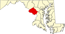
Map of Maryland highlighting Montgomery County.svg
Location of Montgomery County in the U.S. state of Maryland.
Coordinates: 39°7′5.88″N77°11′2.34″W / 39.1183000°N 77.1839833°W / 39.1183000; -77.1839833
Country Flag of the United States.svg United States of America
State Flag of Maryland.svg  Maryland
County Flag of Montgomery County, Maryland.svg Montgomery
Time zone UTC-5 (Eastern (EST))
  Summer (DST) UTC-4 (EDT)
ZIP code
20850, 20855
Area code(s) 301, 240

Shady Grove is an unincorporated area of Montgomery County, Maryland, United States. [1] It has a population of 5,000-7,000, between the cities of Rockville and Gaithersburg, mostly in zip codes 20850 and 20855, though the exact boundaries are not officially defined.
Contents

History

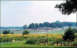
Shady Grove in 1978 Construction of the Shady Grove Plaza Shopping Center (1978).jpg
Shady Grove in 1978

Shady Grove is one of Montgomery County's upper middle class areas. The area is best identified by Shady Grove Road, which is located near exit 8 off of I-270. Other notable places in the area that bear the name are:

Related Research Articles

<span class="mw-page-title-main">Montgomery County, Maryland</span> County in Maryland, United States

Montgomery County is the most populous county in the U.S. state of Maryland. As of the 2020 census, the county's population was 1,062,061, increasing by 9.3% from 2010. The county seat and largest municipality is Rockville, although the census-designated place of Germantown is the most populous place within the county. Montgomery County, which adjoins Washington, D.C., is part of the Washington–Arlington–Alexandria, DC–VA–MD–WV metropolitan statistical area, which in turn forms part of the Baltimore–Washington combined statistical area. Most of the county's residents live in unincorporated locales, of which the most urban are Silver Spring and Bethesda, although the incorporated cities of Rockville and Gaithersburg are also large population centers, as are many smaller but significant places.

<span class="mw-page-title-main">Rockville, Maryland</span> City in Maryland, United States

Rockville is a city in and the county seat of Montgomery County, Maryland, United States, and is part of the Baltimore–Washington metropolitan area. The 2020 census tabulated Rockville's population at 67,117, making it the fourth-largest community in Maryland.

<span class="mw-page-title-main">Darnestown, Maryland</span> Census-designated place in the United States

Darnestown is a United States census-designated place (CDP) and an unincorporated area in Montgomery County, Maryland. The CDP is 17.70 square miles (45.8 km2) with the Potomac River as its southern border and the Muddy Branch as much of its eastern border. Seneca Creek borders portions of its north and west sides. The Travilah, North Potomac, and Germantown census-designated places are adjacent to it, as is the city of Gaithersburg. Land area for the CDP is 16.39 square miles (42.4 km2). As of the 2020 census, the Darnestown CDP had a population of 6,723, while the village of Darnestown is considerably smaller in size and population. Downtown Washington, D.C. is about 22 miles (35 km) to the southeast.

<span class="mw-page-title-main">North Potomac, Maryland</span> Census-designated place named North Potomac in Maryland, United States

North Potomac is a census-designated place and unincorporated area in Montgomery County, Maryland, United States. It is located less than 5 miles (8.0 km) north of the Potomac River, and is about 20 miles (32 km) from Washington, D.C. It has a population of 23,790 as of 2020.

<span class="mw-page-title-main">Travilah, Maryland</span> Census-designated place in Maryland

Travilah is a United States census-designated place and an unincorporated area in Montgomery County, Maryland. It is 17.28 square miles (44.8 km2) located along the north side of the Potomac River, and surrounded by the communities of Potomac, North Potomac, and Darnestown—all census-designated places. It had a population of 11,985 as of the 2020 census.

<span class="mw-page-title-main">Red Line (Washington Metro)</span> Washington Metro rapid transit line

The Red Line is a rapid transit line of the Washington Metro system, consisting of 27 stations in Montgomery County, Maryland, and Washington, D.C., in the United States. It is a primary line through downtown Washington and the oldest and busiest line in the system. It forms a long, narrow "U," capped by its terminal stations at Shady Grove and Glenmont.

<span class="mw-page-title-main">Medical Center station (Washington Metro)</span> Washington Metro station

Medical Center station is a Washington Metro station in Bethesda, Maryland, United States. The island-platformed station was opened on August 25, 1984, and is operated by the Washington Metropolitan Area Transit Authority (WMATA). Providing service for the Red Line, the station serves the National Institutes of Health campus and the Walter Reed National Military Medical Center, and is located at Rockville Pike and South Drive. Since there is little retail in the area and no commuter parking lot, this station is used almost exclusively by employees and visitors to those two institutions.

<span class="mw-page-title-main">Twinbrook station</span> Washington Metro station

Twinbrook station is a rapid transit station on the Red Line of the Washington Metro attached to the Twinbrook neighborhood of Rockville, Maryland. One of a number of stations on the Rockville Pike corridor, it primarily acts as a commuter station.

<span class="mw-page-title-main">Rockville station</span> Washington Metro and MARC Train station

Rockville station is an intermodal train station located in downtown Rockville, Maryland, United States. It is served by the Washington Metro Red Line, MARC Brunswick Line commuter trains, and Amtrak Capitol Limited intercity trains.

<span class="mw-page-title-main">Shady Grove station</span> Washington Metro station

Shady Grove station is a Washington Metro station in Derwood, Maryland, United States. The station opened on December 15, 1984 as part of a four-stop extension of the Red Line from Grosvenor–Strathmore station to Shady Grove. The station is operated by the Washington Metropolitan Area Transit Authority (WMATA).

<span class="mw-page-title-main">Grosvenor–Strathmore station</span> Washington Metro station

Grosvenor–Strathmore station is a rapid transit station on the Red Line of the Washington Metro in North Bethesda, Maryland. Grosvenor–Strathmore is the last above-ground station for Glenmont-bound Red Line trains until NoMa-Gallaudet U; south of the station, trains cross over the Capital Beltway before descending underground. It is one of a number of stations on the Rockville Pike corridor in Montgomery County.

<span class="mw-page-title-main">Doug Duncan</span> American politician from Maryland

Douglas Michael Duncan is a former American politician from Maryland who served as Rockville City Councilman, Rockville Mayor, Montgomery County Executive, and candidate for Governor of Maryland. He is a member of the Democratic Party. Duncan currently serves as president and CEO of Leadership Greater Washington, a position he has held since 2014.

<span class="mw-page-title-main">Derwood, Maryland</span> Census-designated place in Maryland, United States

Derwood is an unincorporated area and census-designated place in east-central Montgomery County, Maryland, United States. It lies just north of Rockville, southeast of Gaithersburg, southwest of Olney, and northwest of the greater Silver Spring area. Derwood was originally "Deer Park" and was then "Deer Wood" before getting its current name.

<span class="mw-page-title-main">Maryland Route 355</span> State highway in Montgomery and Frederick Counties, Maryland, United States

Maryland Route 355 (MD 355) is a 36.75-mile (59.14 km) north–south road in western central Maryland in the United States. The southern terminus of the route, Wisconsin Avenue, is located in Bethesda in Montgomery County, at the county's border with Washington, D.C. It continues south into Washington, D.C. as Wisconsin Avenue NW. The northern terminus is just north of a bridge over Interstate 70 (I-70)/U.S. Route 40 (US 40) in the city of Frederick in Frederick County, where the road continues north as Market Street through Frederick towards MD 26.

<span class="mw-page-title-main">Maryland Route 28</span> State highway in Maryland, US

Maryland Route 28 is a state highway in the U.S. state of Maryland. The state highway runs 37.38 miles (60.16 km) from U.S. Route 15 in Point of Rocks east to MD 182 in Norwood. The western portion of MD 28 is a rural highway connecting several villages in southern Frederick County and western Montgomery County. By contrast, the eastern portion of the state highway is a major east–west commuter route, particularly within Gaithersburg and Rockville.

<span class="mw-page-title-main">Adventist HealthCare Shady Grove Medical Center</span> Hospital in Maryland USA, founded 1979

Adventist HealthCare Shady Grove Medical Center is a 266-licensed bed acute care facility located in Rockville, Maryland. Shady Grove Medical Center provides a range of health services to the community such as high-risk obstetrical care, cardiac and vascular care, oncology services, orthopedic care, surgical services and pediatric care. Opened in 1979 as Shady Grove Adventist Hospital, Shady Grove Medical Center operates as part of Adventist HealthCare, a health-care delivery system that includes hospitals, home health agencies and other health-care services. Adventist HealthCare is headquartered in Gaithersburg, Maryland.

<span class="mw-page-title-main">CASA de Maryland</span> Immigration organization in MD, USA

CASA is a Latino and immigration advocacy-and-assistance organization based in Maryland. It is active throughout the state, but has major foci in Prince George's County, Montgomery County and Baltimore. CASA influences Maryland politics on a wide range of policies, ranging from law-enforcement to education. It also has offices in Virginia, Pennsylvania, and Georgia.

<span class="mw-page-title-main">Maryland Route 119</span> State highway in Montgomery County, Maryland, US, known as Great Seneca Hwy

Maryland Route 119 is a state highway in the U.S. state of Maryland. Also known as Great Seneca Highway, the highway runs 7.47 miles (12.02 km) from MD 28 in Rockville north to Middlebrook Road in Germantown. MD 119 is a four- to six-lane divided highway that connects several residential and commercial neighborhoods in Rockville, Gaithersburg, and Germantown. Great Seneca Highway was planned by Montgomery County in the late 1960s as a local relief route for traffic on parallel Interstate 270 (I-270) between the three communities. By the early 1980s, the highway had become controversial because it was proposed to pass through Seneca Creek State Park. A coalition of civic and environmental groups unsuccessfully pursued litigation to stop the highway. The National Park Service refused permission for the county to build the highway in 1985 but reversed itself two years later, by which time the first segment of the highway in Germantown was nearing completion. The Rockville–Gaithersburg section was completed in 1989 and the controversial segment through the state park was finished in 1990. Almost all of Great Seneca Highway became MD 119 in 1999.

<span class="mw-page-title-main">Seneca, Maryland</span> Unincorporated community in Maryland, United States

Seneca is an unincorporated community in Montgomery County, Maryland, United States. It is located near the intersection of River Road and Seneca Creek, not far from the Chesapeake and Ohio Canal and Potomac River. Its history goes back before the American Revolutionary War and it thrived when the canal was operating—having several warehouses, mills, a store, a hotel, and a school. Fighting occurred in the area on more than one occasion during the American Civil War. The community declined as the C&O Canal declined.

<span class="mw-page-title-main">Veirs Mill Road Line</span> Bus route in Washington Metropolitan Area

The Veirs Mill Road Line, designated Route Q2, Q4, Q6, is a daily bus route operated by the Washington Metropolitan Area Transit Authority between Silver Spring station and Shady Grove station of the Red Line of the Washington Metro. The line operates every 16–30 minutes at all times at a combined frequency of 10 minutes during weekday peak-hours, 15 minutes during the weekday midday and weekends, and 30 minutes during the late nights. All trips roughly take 55–60 minutes. The line operates along the Veirs Mill Road corridor connecting passengers to various Metro stations and communities.

References

  1. U.S. Geological Survey Geographic Names Information System: Shady Grove, Maryland
  2. "The Universities at Shady Grove".