Ashton-Sandy Spring, Maryland

Last updated

Ashton-Sandy Spring, Maryland
2006 11 10 - 108@Brooke - EB 3.JPG
Route 108 in Sandy Spring, Maryland, in November 2006
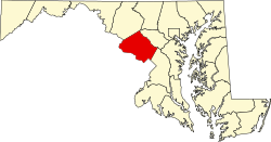
Montgomery County Maryland Incorporated and Unincorporated areas Ashton-Sandy Spring Highlighted.svg
Location of Ashton-Sandy Spring in Montgomery County, Maryland
Coordinates: 39°08′58″N76°59′45″W / 39.14944°N 76.99583°W / 39.14944; -76.99583
CountryFlag of the United States.svg United States
State Flag of Maryland.svg  Maryland
County Flag of Montgomery County, Maryland.svg Montgomery
Area
[1]
  Total10.36 sq mi (26.83 km2)
  Land10.26 sq mi (26.57 km2)
  Water0.10 sq mi (0.26 km2)
Elevation
[2]
440 ft (130 m)
Population
 (2020)
  Total5,746
  Density560.20/sq mi (216.29/km2)
Time zone UTC−5 (Eastern (EST))
  Summer (DST) UTC−4 (EDT)
FIPS code 24-02762
GNIS feature ID2389153 [2]

Ashton-Sandy Spring is a census-designated place (CDP) in Montgomery County, Maryland, United States. The CDP is designated to include the two unincorporated communities of Ashton and Sandy Spring, as well as the smaller community of Brinklow. It had a population of 5,746 as of the 2020 census. [3]

Contents

Geography

According to the U.S. Census Bureau, it has a total area of 7.6 square miles (20 km2), 7.6 square miles (20 km2) of which is land and 0.04 square miles (0.10 km2) (0.26%) of which is water.

Demographics

Historical population
CensusPop.Note
2010 5,628
2020 5,7462.1%
U.S. Decennial Census [4]
2010–2020 [3]

As of census [5] 2010, there were 5,628 people, 1,839 households, and 1,434 families residing in the area. The population density was 740.5 inhabitants per square mile (285.9/km2). There were 1,936 housing units at an average density of 254.7 per square mile (98.3/km2). The racial makeup of the area was 71.7% White, 14.2% African American, 0.2% Native American, 8.3% Asian, 1.6% from other races, and 3.8% from two or more races. Hispanic or Latino of any race were 6.6% of the population.

There were 1,839 households, out of which 35.9% had children under the age of 18 living with them, 66.6% were married couples living together, 8.5% had a female householder with no husband present, and 22.0% were non-families. 19.1% of all households were made up of individuals living alone, and 12.3% had someone living alone who was 65 years of age or older. The average household size was 2.91 and the average family size was 3.34.

In the area the population was spread out, with 25.3% under the age of 18, 6.3% from 18 to 24, 16.7% from 25 to 44, 32.9% from 45 to 64, and 18.8% who were 65 years of age or older. The median age was 46 years. For every 100 females, there were 88.4 males. For every 100 females age 18 and over, there were 85.4 males.

A 2013 survey [5] estimated that the median household income in the area was $119,432, and the median income for a family was $163,403. Males had an estimated median income of $86,250 versus $94,861 for females. The estimated per capita income for the area was $62,468. The survey estimated about 6.9% of families and 7.2% of the population were below the poverty line, including 9.1% of those under age 18 and 9.7% of those age 65 or over.

Related Research Articles

<span class="mw-page-title-main">Spring Lake, Florida</span> Census-designated place in Florida, United States

Spring Lake is an unincorporated community and census-designated place (CDP) in Hernando County, Florida, United States. The population was 458 at the 2010 census, up from 327 at the 2000 census.

<span class="mw-page-title-main">Mokulēia, Hawaii</span> Census-designated place in Hawaii, United States

Mokulēʻia is a North Shore community and census-designated place (CDP) in the Waialua District on the island of Oʻahu, City & County of Honolulu, Hawaiʻi, United States. Mokulēʻia means "isle [of] abundance" in Hawaiian. As of the 2020 census, the CDP had a population of 1,816. Features of interest here include Mokulēʻia Beach, Mokulēʻia Polo Field, and Dillingham Airfield, west of the town.

<span class="mw-page-title-main">Ferndale, Maryland</span> Census-designated place in Maryland, United States

Ferndale is a census-designated place (CDP) in Anne Arundel County, Maryland, United States. At the 2010 census, the population was 16,746.

<span class="mw-page-title-main">Naval Academy, Maryland</span> Census-designated place in Maryland, United States

Naval Academy is a census-designated place (CDP) in Anne Arundel County, Maryland, United States, which covers the campus of the United States Naval Academy. The population was 4,802 at the 2010 census.

<span class="mw-page-title-main">Riviera Beach, Maryland</span> Census-designated place in Maryland, United States

Riviera Beach is a census-designated place in Anne Arundel County, Maryland, United States. The population was 12,677 at the 2010 U.S. census.

<span class="mw-page-title-main">Edgemere, Maryland</span> Census-designated place in Maryland, United States

Edgemere is an unincorporated community and census-designated place in Baltimore County, Maryland, United States. The population was 8,669 at the 2010 census. Founded in 1899 as Edgemere being renamed from previous name "Fitzell". Meeting held at the Fitzell Farm which was situated where the old Rheem plant was located.

<span class="mw-page-title-main">Rosedale, Maryland</span> Census-designated place in Maryland, United States

Rosedale is an unincorporated community and census-designated place in Baltimore County, Maryland, United States. The population was 19,257 at the 2010 United States Census.

<span class="mw-page-title-main">Dunkirk, Maryland</span> Census-designated place in Maryland, United States

Dunkirk is a census-designated place (CDP) in Calvert County, Maryland, United States. The population was 2,521 at the 2010 census.

<span class="mw-page-title-main">Fairland, Maryland</span> Census-designated place in Maryland, United States

Fairland is a census-designated place and an unincorporated area in Montgomery County, Maryland, United States. It had a population of 25,396 per the 2020 census.

<span class="mw-page-title-main">Potomac, Maryland</span> Census-designated place in Maryland, United States

Potomac is an unincorporated community and census-designated place in Montgomery County, Maryland, United States. As of the 2020 census, it had a population of 47,018. It is named after the nearby Potomac River. A part of the Washington metropolitan area, many Potomac residents work in nearby Washington, D.C., and Northern Virginia.

<span class="mw-page-title-main">Redland, Maryland</span> Census-designated place in Maryland, United States

Redland is a census-designated place and an unincorporated area in Montgomery County, Maryland, United States. It had a population of 18,592 as of the 2020 census.

<span class="mw-page-title-main">Fairmount, Maryland</span> CDP in Maryland, United States

Fairmount is a census-designated place (CDP) in Somerset County, Maryland, United States. The population was 537 at the 2000 census. It is included in the Salisbury, Maryland-Delaware Metropolitan Statistical Area.

<span class="mw-page-title-main">California, Maryland</span> CDP in Maryland, United States

California is a census-designated place and community in St. Mary's County, Maryland, United States. The population was 11,857 at the 2010 census, an increase of 27.4% from the 2000 census. California has been growing with the spread of population from the older adjacent community of Lexington Park and the growth in both technology-related and defense-related jobs at the Patuxent River Naval Air Station. There are department stores and numerous shopping centers situated along Maryland Highway 235. Maryland Route 4 crosses Highway 235 in California, providing access to the wide Governor Thomas Johnson Bridge and the popular weekend resort town of Solomons on its opposite side. Bridge-bound traffic is notorious for backing up during rush hour.

<span class="mw-page-title-main">West Ocean City, Maryland</span> CDP in Maryland, United States

West Ocean City is a census-designated place (CDP) in Worcester County, Maryland, United States. The population was 4,375 at the 2010 census. It is part of the Salisbury, Maryland-Delaware Metropolitan Statistical Area.

<span class="mw-page-title-main">Isleta Village Proper, New Mexico</span> Census-designated place in New Mexico, United States

Isleta Village Proper is a census-designated place (CDP) in Bernalillo County, New Mexico, United States. The population was 491 at the 2010 census. It is part of the Albuquerque Metropolitan Statistical Area.

<span class="mw-page-title-main">Sandy, Pennsylvania</span> Census-designated place in Pennsylvania, United States

Sandy is a census-designated place (CDP) in Clearfield County, Pennsylvania, United States. The population was 1,362 at the 2020 census.

<span class="mw-page-title-main">Alum Creek, West Virginia</span> Census-designated place in West Virginia, United States

Alum Creek is a census-designated place (CDP) in Kanawha and Lincoln counties along the Coal River in the U.S. state of West Virginia. It includes the unincorporated communities of Alum Creek, Forks of Coal, and Priestley. The CDP had a population of 1,749 at the 2010 census, down from 1,839 at the 2000 census.

<span class="mw-page-title-main">Calverton, Maryland</span> Census-designated place in Maryland, United States

Calverton is an unincorporated area and census-designated place located on the boundary between Montgomery and Prince George's counties, Maryland, in the United States. At the 2020 census, it had a population of 17,316.

<span class="mw-page-title-main">Hillandale, Maryland</span> Census-designated place in Maryland, United States

Hillandale is an unincorporated area and census-designated place located in Montgomery and Prince George's counties, Maryland, United States. As of the 2020 census, it had a population of 5,774. Hillandale is contained between the Prince George's / Montgomery County line to the east, the Anacostia River to the west, McCeney Avenue to the north, and D.C.'s Capital Beltway to the south. It borders the communities of Adelphi, Avenel, White Oak and Beltsville.

<span class="mw-page-title-main">Pleasant Valley (CDP), New York</span> Census-designated place in New York, United States

Pleasant Valley is a census-designated place (CDP) in the southwestern part of the town of Pleasant Valley in Dutchess County, New York, United States. The population was 1,145 at the 2010 census. It is part of the Poughkeepsie–Newburgh–Middletown, NY Metropolitan Statistical Area as well as the larger New York–Newark–Bridgeport, NY-NJ-CT-PA Combined Statistical Area.

References

  1. "2020 U.S. Gazetteer Files". United States Census Bureau. Retrieved April 26, 2022.
  2. 1 2 U.S. Geological Survey Geographic Names Information System: Ashton-Sandy Spring, Maryland
  3. 1 2 "QuickFacts: Ashton-Sandy Spring CDP, Maryland". United States Census Bureau. Retrieved August 17, 2021.
  4. "U.S. Decennial Census". United States Census Bureau. Retrieved September 12, 2014.
  5. 1 2 "U.S. Census website". United States Census Bureau . Retrieved March 3, 2015.