Forest Glen Park, Maryland

Last updated

Forest Glen Park, Maryland
Forest Glen Park Maryland Location Map.svg
Overview map of Forest Glen Park
USA Maryland location map.svg
Red pog.svg
Forest Glen Park
Usa edcp location map.svg
Red pog.svg
Forest Glen Park
Coordinates: 39°00′42″N77°03′33″W / 39.01167°N 77.05917°W / 39.01167; -77.05917 (Forest Glen Park, Maryland) [1]
Country Flag of the United States.svg United States
State Flag of Maryland.svg  Maryland
County Montgomery
Established1887
Founded byForest Glen Improvement Company
Elevation
[1]
96 m (315 ft)
Time zone UTC-5 (Eastern (EST))
  Summer (DST) UTC-4 (EDT)
ZIP Code
20910
Area code 301 & 240
GNIS feature ID590215 [1]

Forest Glen Park is an unincorporated community in Montgomery County, Maryland, United States, and a residential neighborhood within the Silver Spring census-designated place. The community is adjacent to Rock Creek, Rock Creek Regional Park, and to the United States Army's Forest Glen Annex.

Contents

Forest Glen Park and the Forest Inn at the nearby National Park Seminary were developed in the 1880s, when the area was developed by the Forest Glen Improvement Company. The community was laid out in 1887 as one of Montgomery County's first residential subdivisions. It was developed due to the growth of Washington, D.C. and its proximity to the Baltimore and Ohio Railroad's Metropolitan Branch. Forest Glen Park initially consisted of summer homes and cottages centered around the Forest Inn. Later, Victorian and early to mid-20th-century residences were developed. The Forest Inn became part of the National Park Seminary in 1894, which became the National Park College in 1937. The college was acquired by the U.S. Army in 1942, after which the seminary property became part of the Forest Glen Annex. In 2004, the National Park Seminary was developed into a residential complex.

Geography

Forest Glen Park is an unincorporated community within the census-designated place of Silver Spring and is centered around an intersection, where Forsythe, Wilton, Woodley, and Woodstock Avenues intersect. [2] [3]

Forest Glen Park, Maryland

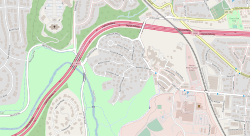
The community is located within forested hills to the immediate east of Rock Creek and Rock Creek Regional Park. [1] [4] The Washington D.C. Temple is located approximately 0.39 miles (0.63 km) northwest of Forest Glen Park, and is a prominent landmark visible throughout the community. [2] Forest Glen Park is bordered by the Forest Glen Creek Valley and the Capital Beltway Highway to the north, the historic National Park Seminary and the CSX Metropolitan Subdivision to the east, the United States Army's Forest Glen Annex installation to the southeast, and Rock Creek and Rock Creek Regional Park to the west and south. [1] [4] Forest Glen Park is located approximately 1.4 miles (2.3 km) southeast of Kensington, approximately 1.9 miles (3.1 km) northwest of Downtown Silver Spring, and approximately 2.7 miles (4.3 km) northeast of Bethesda. [4] To the south of Forest Glen Park and Forest Glen Annex, Ireland Creek flows from northeast to southwest through a forested valley into Rock Creek. [4] [5]

The Maryland-National Capital Park and Planning Commission (M-NCPPC) includes Forest Glen Park within the North Silver Spring section of its North and West Silver Spring Master Plan area. [6] The western section of Forest Glen Park consists of single-family residences, and the National Park Seminary section in the east of Forest Glen Park consists of multi-family residences. [7]

History

Forest Glen Improvement Company

Braemar, one of the original cottages in Forest Glen Park South southeast elevation, with scale - Braemar, Silver Spring, Montgomery County, MD HABS MD-1252-3 ((cropped).jpg
Braemar, one of the original cottages in Forest Glen Park

Forest Glen Park and the Forest Inn, at present day National Park Seminary, were developed by the Forest Glen Improvement Company in 1887. [8] [9] Originally consisting of 166 acres (67 ha), Forest Glen Park was one of the earliest residential subdivisions in Montgomery County and was developed as a result of Washington, D.C.'s growing population. [8] [10] The area was easily accessible to Washington D.C., as it was situated along the Baltimore and Ohio Railroad's Metropolitan Branch. [8] [9] [11] The Forest Glen Improvement Company developed Forest Glen Park as a residential suburb and resort for Washington D.C. residents seeking a more natural environment. [8] [9] The company was recorded in corporate record books on July 15, 1887, and the plat for the Forest Glen Park subdivision was recorded on July 31, 1887. [8] The Forest Glen Improvement Company laid out the neighborhood's avenues to conform with the natural topography and ensured that the lot sizes were large, to allow for "handsome villa sites." [12] The company described the neighborhood as "Washington's most desirable suburb." [11] By April 1887, over two-thirds of the development had been sold. [13] The residential section of Forest Glen Park initially consisted of summer homes and cottages centered around the Forest Inn at the National Park Seminary. [8] It later grew to consist of Victorian-style and early 20th-century residences intermixed with homes built in the 1940s. [14]

National Park Seminary and Forest Glen Annex

Aerial view of Forest Glen Park and the National Park Seminary Aerial view of Forest Glen and environs from low altitude, approximately 250' - National Park Seminary, Bounded by Capitol Beltway (I-495), Linden Lane, Woodstove Avenue, and HABS MD,16-SILSPR,2-8 (cropped).jpg
Aerial view of Forest Glen Park and the National Park Seminary

The Forest Inn proved unsuccessful, and the resort property was acquired by Dr. and Mrs. John A. I. Cassedy, who transformed it into a women's college, known as the National Park Seminary. [15] [16] Dr. James E. Ament acquired the seminary in 1916. During his tenure, he expanded the seminary's campus and enlarged its buildings. [16] Dr. Roy Tasco Davis purchased the seminary in 1937, and transitioned the school into a junior college with a business-oriented curriculum, after which it became known as National Park College. [15] [16] During World War II, the War Powers Act of 1941 required Davis to transfer the college to the U.S. Army in 1942. [15] [16] [17] The seminary grounds remained under the ownership of the Army, as part of the Walter Reed Army Medical Center Forest Glen Annex, until 2004. [16] [17] The grounds were listed on the National Register of Historic Places in 1972 as the National Park Seminary Historic District. [16] By the 1980s, many of the seminary buildings had fallen into disrepair, and the Save Our Seminary non-profit was established in 1988 to preserve the historic structures. [17] The General Services Administration transferred the 32-acre (13 ha) seminary property to Montgomery County in 2004. [16] [17] The National Park Seminary was then transferred to a partnership between developers EYA and the Alexander Company, and the grounds were developed into a residential complex. [16]

Command of the Forest Glen Annex transferred from Walter Reed Army Medical Center to Fort Detrick in 2008, following the 2005 Base Realignment and Closure Commission. [18] The Forest Glen Annex is home to the Walter Reed Army Institute of Research and the National Museum of Health and Medicine. [18]

Capital Beltway

Capital Beltway, viewed from the Linden Lane overpass 2019-07-11 13 21 39 View east along Interstate 495 (Capital Beltway) from the overpass for Linden Lane in Silver Spring, Montgomery County, Maryland.jpg
Capital Beltway, viewed from the Linden Lane overpass

The Capital Beltway (I-495) was constructed to the north of Forest Glen Park in the 1960s. The Maryland State Roads Commission built the Linden Lane bridge over the Beltway, for which the commission received an award for bridge design from the American Institute of Steel Construction. [19]

Government

Forest Glen Park is serviced by two civic associations. The western section of the community, which consists of single-family residences, is serviced by the Forest Glen Park Citizens' Association, while the National Park Seminary, which consists of multi-family residences, is serviced by the National Park Seminary Master Association. [20] Forest Glen Park is located within Montgomery County Council's District 1, which is represented by Democrat Andrew Friedson, as of 2021. [21] [22] Forest Glen Park is in Maryland House of Delegates Legislative District 18, and is represented by Democrats Aaron Kaufman, Emily K. Shetty, and Jared Solomon. [23] [24] [25] As part of Legislative District 18, the community is represented in the Maryland Senate by Democrat Jeff Waldstreicher. [26] Forest Glen Park is located within Maryland's 8th congressional district, represented by Jamie Raskin in the United States House of Representatives. [27]

Education

Albert Einstein High School Einstein hs mcps 20201024 082539 1 crop.jpg
Albert Einstein High School

Forest Glen Park is located within the Montgomery County Public School's school district, and is served by Woodlin Elementary School and Sligo Middle School in Silver Spring, and Albert Einstein High School in Kensington. [28] Albert Einstein High School is part of the Downcounty Consortium, which is a group of five high schools which offer academy programs available to students at any of the five schools. [29] The consortium also includes Einstein, John F. Kennedy High School in Glenmont, Montgomery Blair High School in Silver Spring, Wheaton High School in Wheaton, and Northwood High School in Kemp Mill. [29]

Transportation

Forest Glen Park is serviced by Ride On bus route numbers 4 and 5. [30] [31] [32] Access to the Washington Metro is available on the Red Line in nearby Forest Glen and downtown Silver Spring. [33] By 2023, Purple Line service will be available at the nearby 16th Street–Woodside and Lyttonsville stations. [34]

Recreation

Rock Creek and Rock Creek Regional Park are located immediately to the west and south of Forest Glen Park. [35] [36] Rock Creek Regional Park is an 1,800-acre (730 ha) park operated by the M-NCPPC and the Montgomery County Department of Parks and contains a network of 13 miles (21 km) of trails, connecting to the Rock Creek Hiker-Biker Trail. [36] [37] Rock Creek Regional Park connects with Rock Creek Park at the D.C. border. [35] [36]

Related Research Articles

<span class="mw-page-title-main">Montgomery County, Maryland</span> County in Maryland, United States

Montgomery County is the most populous county in the U.S. state of Maryland. As of the 2020 census, the county's population was 1,062,061, increasing by 9.3% from 2010. The county seat and largest municipality is Rockville, although the census-designated place of Germantown is the most populous place within the county. Montgomery County, which adjoins Washington, D.C., is part of the Washington–Arlington–Alexandria, DC–VA–MD–WV metropolitan statistical area, which in turn forms part of the Baltimore–Washington combined statistical area. Most of the county's residents live in unincorporated locales, of which the most urban are Silver Spring and Bethesda, although the incorporated cities of Rockville and Gaithersburg are also large population centers, as are many smaller but significant places.

<span class="mw-page-title-main">Silver Spring, Maryland</span> Census-designated place in Maryland, United States

Silver Spring is a census-designated place (CDP) in southeastern Montgomery County, Maryland, United States, near Washington, D.C. Although officially unincorporated, it is an edge city with a population of 81,015 at the 2020 census, making it the fifth-most populous place in Maryland after Baltimore, Columbia, Germantown, and Waldorf.

<span class="mw-page-title-main">Takoma Park, Maryland</span> City in the United States

Takoma Park is a city in Montgomery County, Maryland, United States. It is a suburb of Washington, and part of the Washington metropolitan area. Founded in 1883 and incorporated in 1890, Takoma Park, informally called "Azalea City", is a Tree City USA and a nuclear-free zone. A planned commuter suburb, it is situated along the Metropolitan Branch of the historic Baltimore and Ohio Railroad, just northeast of Washington, D.C., and it shares a border and history with the adjacent Washington, D.C. neighborhood of Takoma. It is governed by an elected mayor and six elected councilmembers, who form the city council, and an appointed city manager, under a council-manager style of government. The city's population was 17,629 at the 2020 census.

<span class="mw-page-title-main">Forest Glen, Maryland</span> Census-designated place in Maryland, United States

Forest Glen is a census-designated place (CDP) in Montgomery County, Maryland, United States. Its population was 6,897 as of the 2020 census.

<span class="mw-page-title-main">Forest Glen station</span> Washington Metro station

Forest Glen station is a side platformed Washington Metro station in Forest Glen, Maryland, United States. The station was opened on September 22, 1990, and is operated by the Washington Metropolitan Area Transit Authority (WMATA). Its opening coincided with the completion of 3.2 miles (5.1 km) of rail north of the Silver Spring station and the opening of Wheaton station. Providing service for the Red Line, the station is located at Georgia Avenue and Forest Glen Road. The station is the deepest in the system at 196 feet (60 m) deep, so high-speed elevators, rather than escalators, are used for access to the surface.

<span class="mw-page-title-main">Sligo Creek</span> Stream in Maryland, United States of America

Sligo Creek is a free-flowing tributary of the Northwest Branch of the Anacostia River in Maryland. The creek is approximately 9.1 miles (14.6 km) long, with a drainage area of about 11.6 square miles (30 km2).

<span class="mw-page-title-main">Capital Beltway</span> Highway in the Washington metropolitan area

The Capital Beltway is a 64-mile (103 km) auxiliary Interstate Highway in the Washington metropolitan area that surrounds Washington, D.C., the capital of the United States, and its inner suburbs in adjacent Maryland and Virginia. It is the basis of the phrase "inside the Beltway", used when referring to issues dealing with US federal government and politics. The highway is signed as Interstate 495 (I-495) for its entire length, and its southern and eastern half runs concurrently with I-95.

<span class="mw-page-title-main">Rock Creek (Potomac River tributary)</span> Tributary of the Potomac River in Maryland and Washington, D.C., United States

Rock Creek is a tributary of the Potomac River, in the United States, that empties into the Atlantic Ocean via the Chesapeake Bay. The 32.6-mile (52.5 km) creek drains about 76.5 square miles (198 km2). Its final quarter-mile is affected by tides.

<span class="mw-page-title-main">Glen Echo Park (Maryland)</span> United States historic place

Glen Echo Park is an arts and cultural center in Glen Echo, Maryland, a suburb of Washington, D.C. Located about 9 miles (14 km) northwest of the city's downtown area, the park's site was initially developed in 1891 as a National Chautauqua Assembly.

<span class="mw-page-title-main">Capital Crescent Trail</span> Rail trail in greater Washington, D.C.

The Capital Crescent Trail (CCT) is a 7.04-mile (11.33 km), shared-use rail trail that runs from Georgetown in Washington, D.C., to Bethesda, Maryland. An extension of the trail from Bethesda to Silver Spring along a route formerly known as the Georgetown Branch Trail is being built as part of the Purple Line light rail project.

<span class="mw-page-title-main">Lake Needwood</span> Reservoir in Derwood, Maryland

Lake Needwood is a 75-acre (300,000 m2) reservoir in Derwood, Maryland, United States. Located east of Rockville, in the eastern part of Montgomery County, it is situated on Rock Creek. The lake was created by damming Rock Creek in 1965 with the goal of providing flood control and reducing soil erosion. Lake Needwood also protects the water quality of the creek by functioning as a retention basin to trap sediment from storm-water runoff.

<span class="mw-page-title-main">National Park Seminary</span> Historic district in Maryland, United States

National Park Seminary — later called National Park College — was a private girls' school open from 1894 to 1942. Located in Forest Glen Park, Maryland, its name alludes to nearby Rock Creek Park. The historic campus is to be preserved as the center of a new housing development.

<span class="mw-page-title-main">Streetcars in Washington, D.C., and Maryland</span>

Streetcars and interurbans operated in the Maryland suburbs of Washington, D.C., between 1890 and 1962. Lines in Maryland were established as separate legal entities, but eventually they were all owned or leased by DC Transit. Unlike the Virginia lines, the Washington and Maryland lines were scheduled as a single system. Most of the streetcar lines were built with grand plans in mind, but none succeeded financially. A combination of the rise of the automobile, various economic downturns and bustitution eventually spelled the end of streetcars in southern Maryland.

<span class="mw-page-title-main">Seneca, Maryland</span> Unincorporated community in Maryland, United States

Seneca is an unincorporated community in Montgomery County, Maryland, United States. It is located near the intersection of River Road and Seneca Creek, not far from the Chesapeake and Ohio Canal and Potomac River. Its history goes back before the American Revolutionary War and it thrived when the canal was operating—having several warehouses, mills, a store, a hotel, and a school. Fighting occurred in the area on more than one occasion during the American Civil War. The community declined as the C&O Canal declined.

<span class="mw-page-title-main">Forest Glen Annex</span> Military research site in Maryland, United States

The Forest Glen Annex is a 136-acre (0.55 km2) U.S. Army installation in the Forest Glen Park neighborhood of Silver Spring, Maryland, United States. It is situated between Brookville Road and Linden Lane. Since 1999, the Annex has been the site of the Walter Reed Army Institute of Research (WRAIR) and the Naval Medical Research Center (NMRC), along with smaller units.

<span class="mw-page-title-main">Northwest Branch Anacostia River</span> Anacostia River tributary in Maryland, U.S.

Northwest Branch Anacostia River is a 21.5-mile-long (34.6 km) free-flowing stream in Montgomery County and Prince George's County, Maryland. It is a tributary of the Anacostia River, which flows to the Potomac River and the Chesapeake Bay.

<span class="mw-page-title-main">Maryland Route 192</span> State highway in Montgomery County, Maryland, United States

Maryland Route 192 is a state highway in the U.S. state of Maryland. The highway runs 2.53 miles (4.07 km) from Summit Avenue in Kensington east to MD 97 in Forest Glen. MD 192 connects MD 185 with the Kensington station on MARC's Brunswick Line and MD 97 and Interstate 495 (I-495) with the Forest Glen station on the Washington Metro's Red Line. The highway was constructed from Forest Glen to Kensington in the mid-1920s. MD 192 also included three sections between MD 97 and U.S. Route 29 in Four Corners built in the mid-1930s. The final segment east of MD 97 was removed from the state highway system in the late 1980s.

Lyttonsville is a mostly residential neighborhood of Silver Spring, Maryland. Established in the 1850s, it is among the oldest neighborhoods in Montgomery County and is a notable example of a community created by free African Americans before the Civil War. Today, Lyttonsville is a 68-acre, predominantly residential neighborhood mostly composed of modest single-family homes.

<span class="mw-page-title-main">Rock Creek Trails</span> Hiking trail

The Rock Creek Trails are a series of trails through the Rock Creek valley and along the Potomac River in Washington, DC and Montgomery County, MD. The main route extends 22 miles from Lake Needwood in Maryland to the Inlet Bridge in Washington, DC, with a loop in the north part of Rock Creek Park and other trails through the Klingle Valley, Turkey Branch Valley and along the North Branch of Rock Creek. There are three separate trails that make up the main Rock Creek Trail route and others that connect to it. Along the Potomac River from Arlington Memorial Bridge to Rock Creek is a section sometimes called the Shoreline Trail.

Rock Creek Forest is a mostly residential neighborhood in Silver Spring / Chevy Chase, Maryland. It is bordered by Chevy Chase to the east, Silver Spring to the west, Maryland Route 410 to the north, and the border with Washington, D.C., to the south. The historically African-American neighborhood of Lyttonsville is to the north, while Rock Creek Park and the neighborhoods of North Portal Estates / Colonial Village / Shepherd Park are to the south.

References

  1. 1 2 3 4 5 Geographic Names Information System, United States Geological Survey. "Geographic Names Information System: Feature Detail Report for Forest Glen Park (Feature ID: 590215)" . Retrieved June 20, 2020.
  2. 1 2 Map centered on Forest Glen Park, Silver Spring, MD (Map). Google Maps. 2021. Archived from the original on January 23, 2021. Retrieved January 23, 2021.
  3. Silver Spring CDP, Maryland (Map). United States Census Bureau. 2021. Archived from the original on January 23, 2021. Retrieved January 23, 2021.
  4. 1 2 3 4 Kensington Quadrangle – Maryland (PDF) (Map). 1:24,000. 7.5 Minute Series (Topographic). United States Geological Survey. 2019. OCLC   777258940. Archived (PDF) from the original on January 24, 2021. Retrieved January 24, 2021.
  5. "Facts About: Forest Glen Annex" (PDF). Maryland Department of the Environment. 2015. Archived (PDF) from the original on October 19, 2020. Retrieved January 24, 2021.
  6. Maryland-National Capital Park and Planning Commission 2000 , pp. 10–11 & 17.
  7. Maryland-National Capital Park and Planning Commission 2000 , pp. 18–19.
  8. 1 2 3 4 5 6 Tamburrino 2001 , p. 8 of the PDF file.
  9. 1 2 3 Forest Glen Improvement Company 1887 , pp. 5–6.
  10. "Forest Glen and Thereabouts". The Evening Star . Washington, D.C. July 27, 1889. p. 7. Archived from the original on January 23, 2021. Retrieved January 23, 2021 via Newspapers.com.
  11. 1 2 "Forest Glen Park". The Evening Star . Washington, D.C. April 4, 1887. p. 1. Archived from the original on January 23, 2021. Retrieved January 23, 2021 via Newspapers.com.
  12. Forest Glen Improvement Company 1887 , p. 8.
  13. "Traffic In District Dirt". The National Republican . Washington, D.C. April 22, 1887. p. 1. Archived from the original on January 23, 2021. Retrieved January 23, 2021 via Newspapers.com.
  14. Tamburrino 2001 , p. 5 of the PDF file.
  15. 1 2 3 Miller 1972 , p. 7 of the PDF file.
  16. 1 2 3 4 5 6 7 8 "National Park Seminary Overview". Save Our Seminary. 2021. Archived from the original on May 20, 2020. Retrieved January 24, 2021.
  17. 1 2 3 4 Orton, Kathy (December 8, 2017). "Former sorority house at National Park Seminary undergoes painstaking renovation". The Washington Post . Washington, D.C. Archived from the original on December 15, 2017. Retrieved January 24, 2021.
  18. 1 2 Palk, Justin M. (October 7, 2008). "Fort Detrick to take over Forest Glen". Frederick News-Post . Frederick, Maryland. Archived from the original on January 24, 2021. Retrieved January 24, 2021.
  19. "State Wins Award For Bridge Design". The Daily Times . Salisbury, Maryland. November 11, 1965. p. 21. Archived from the original on January 23, 2021. Retrieved January 23, 2021 via Newspapers.com.
  20. Montgomery County Association Finder (Map). Montgomery County, Maryland, Planning Department. 2013. Archived from the original on January 23, 2021. Retrieved January 23, 2021.
  21. Montgomery County Council Map (Map). Montgomery County Council. 2021. Archived from the original on October 17, 2020. Retrieved January 23, 2021.
  22. "Andrew Friedson Councilmember". Montgomery County Council. 2021. Archived from the original on January 20, 2021. Retrieved January 23, 2021.
  23. Maryland Legislative Districts (Map). Maryland Department of Planning. 2021. Archived from the original on November 16, 2020. Retrieved January 24, 2021.
  24. Montgomery County Legislative Districts (PDF) (Map). Maryland Department of Planning. 2010. Archived (PDF) from the original on June 16, 2020. Retrieved January 24, 2021.
  25. "Delegates By District". Maryland House of Delegates. 2021. Archived from the original on October 31, 2020. Retrieved January 24, 2021.
  26. "Senators By District". Maryland Senate. 2021. Archived from the original on December 5, 2020. Retrieved January 24, 2021.
  27. 8th Congressional district of Maryland: Zip Code 20910 (Map). United States House of Representatives. 2021. Archived from the original on January 23, 2021. Retrieved January 23, 2021.
  28. "School Assignment Tool". Montgomery County Public Schools. 2021. Archived from the original on November 24, 2020. Retrieved January 24, 2021.
  29. 1 2 "About the Downcounty Consortium". Montgomery County Public Schools. 2021. Archived from the original on November 7, 2020. Retrieved January 24, 2021.
  30. Montgomery County Transit Services Map (PDF) (Map). Montgomery County, Maryland, Department of Transportation. 2016. Archived (PDF) from the original on December 1, 2020. Retrieved January 23, 2021.
  31. Ride On Route 4 Map (PDF) (Map). Montgomery County, Maryland, Government. 2021. Archived (PDF) from the original on November 3, 2020. Retrieved January 23, 2021.
  32. Ride On Route 5 Map (PDF) (Map). Montgomery County, Maryland, Government. 2021. Archived (PDF) from the original on October 28, 2020. Retrieved January 23, 2021.
  33. 2019 System Map (PDF) (Map). Washington Metropolitan Area Transit Authority. 2020. Archived (PDF) from the original on January 4, 2021. Retrieved January 23, 2021.
  34. Purple Line Alignment Map (Map). Maryland Transit Administration, Maryland Department of Transportation. July 2017. Archived from the original on November 11, 2020. Retrieved January 23, 2021.
  35. 1 2 Rock Creek Trail (PDF) (Map). Maryland-National Capital Park and Planning Commission. November 2019. Archived (PDF) from the original on January 24, 2021. Retrieved January 24, 2021.
  36. 1 2 3 Rock Creek Hiker-Biker Trail (PDF) (Map). Montgomery County Department of Parks. August 2012. Archived (PDF) from the original on September 17, 2014. Retrieved January 24, 2021.
  37. "Rock Creek Regional Park". Montgomery County Department of Parks. 2021. Archived from the original on January 16, 2021. Retrieved January 24, 2021.

Bibliography