Ten Mile Creek, Maryland

Last updated

Ten Mile Creek, Maryland
USA Maryland location map.svg
Red pog.svg
Ten Mile Creek
Usa edcp location map.svg
Red pog.svg
Ten Mile Creek
Coordinates: 39°13′36″N77°18′37″W / 39.22667°N 77.31028°W / 39.22667; -77.31028
Country Flag of the United States.svg  United States of America
State Flag of Maryland.svg  Maryland
County Flag of Montgomery County, Maryland.svg Montgomery
Area
[1]
  Total5.84 sq mi (15.12 km2)
  Land5.79 sq mi (15.00 km2)
  Water0.04 sq mi (0.12 km2)
Elevation
[2]
459 ft (140 m)
Population
 (2020) [3]
  Total1,012
  Density174.72/sq mi (67.47/km2)
Time zone UTC-5 (Eastern (EST))
  Summer (DST) UTC-4 (EDT)
ZIP code
20841 (Boyds)
FIPS code 24-77262
GNIS feature ID2806304 [2]

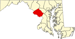
Ten Mile Creek is a census-designated place in Montgomery County, Maryland, United States. [4] [5] It was first listed as a CDP for the 2020 census, when it had a population of 1,012. [6]

Contents

Demographics

2020 census

Ten Mile Creek CDP, Maryland - Demographic Profile
(NH = Non-Hispanic)
Race / EthnicityPop 2020 [7] % 2020
White alone (NH)52651.98%
Black or African American alone (NH)20620.36%
Native American or Alaska Native alone (NH)20.20%
Asian alone (NH)343.36%
Pacific Islander alone (NH)00.00%
Some Other Race alone (NH)10.10%
Mixed Race/Multi-Racial (NH)363.56%
Hispanic or Latino (any race)20720.45%
Total1,012100.00%

Note: the US Census treats Hispanic/Latino as an ethnic category. This table excludes Latinos from the racial categories and assigns them to a separate category. Hispanics/Latinos can be of any race.

Related Research Articles

Perkins is a census-designated place and unincorporated community in Jenkins County, Georgia, United States. As of the 2010 census it had a population of 91.

<span class="mw-page-title-main">Greenbackville, Virginia</span> Census-designated place in Virginia, United States

Greenbackville is a census-designated place (CDP) 4.5 miles (5 km) south of Stockton, Maryland in Accomack County, Virginia, located just south of the Maryland state line. Per the 2020 census, the population was 173.

<span class="mw-page-title-main">Deep Creek, Accomack County, Virginia</span> Census-designated place in Virginia, United States

Deep Creek is a census-designated place (CDP) in Accomack County, Virginia, United States. Per the 2020 census, the population was 94.

Crumpton is a census-designated place in Queen Anne's County, Maryland, United States. Crumpton is located along the Chester River, 5 miles (8.0 km) west-southwest of Millington. Crumpton has a post office with the ZIP code 21628.

<span class="mw-page-title-main">Yarborough Landing, Arkansas</span> Census-designated place in Arkansas, United States

Yarborough Landing is a census-designated place in Little River County, Arkansas, United States. Per the 2020 census, the population was 457.

<span class="mw-page-title-main">Marlboro Meadows, Maryland</span> Census-designated place in Maryland

Marlboro Meadows is an unincorporated community and census-designated place (CDP) in Prince George's County, Maryland, United States. Per the 2020 census, the population was 3,655. It was newly delineated for the 2010 census prior to which the area was part of the Greater Upper Marlboro census-designated place.

Mount Pleasant is a census-designated place and unincorporated community in Marshall County, Mississippi, United States, located along U.S. Highway 72 at State Highway 311. The community has a volunteer fire department on Boswell Road, and a K-12 school located off Highway 72.

Victoria is a census-designated place and unincorporated community in Marshall County, Mississippi, United States. It was first listed as a CDP in the 2020 census, which recorded a population of 1,066.

Morgantown is a census-designated place (CDP) in Adams County, Mississippi, United States, located to the northeast of the city of Natchez. As of the 2020 census, it had a population of 1,334.

Cleary is an unincorporated community and census-designated place in Rankin County, Mississippi, United States. Per the 2020 census, the population was 1,688.

Robinhood is an unincorporated community and census-designated place in Rankin County, Mississippi, United States. Per the 2020 census, the population was 1,491.

Edisto is an unincorporated community and census-designated place in Orangeburg County, South Carolina, United States. Its population was 2,058 as of the 2020 census. U.S. Route 601 passes through the community.

Georgetown is an unincorporated community and census-designated place in western Kent County, Maryland, United States. Per the 2020 census, the population was 117. It should not be confused with the community of the same name 22 miles (35 km) to the northeast on the Kent/Cecil County border.

Chesapeake Landing is a census designated place in Kent County, Maryland, United States. Per the 2020 Census, the population was 472.

Wildewood is a planned community and census-designated place (CDP) in St. Mary's County, Maryland, United States. It is in east-central St. Mary's County, 7 miles (11 km) east of Leonardtown, the county seat, and 58 miles (93 km) southeast of Washington, D.C. It is bordered to the east by the unincorporated community of California.

Long Creek is an unincorporated community and census-designated place (CDP) in Pender County, North Carolina, United States. It was first listed as a CDP in the 2020 census with a population of 277.

Roberdel, also known as Roberdell, is an unincorporated community and census-designated place (CDP) in Richmond County, North Carolina, United States. It was first listed as a CDP in the 2020 census with a population of 246.

Pine Ridge is an unincorporated community and census-designated place (CDP) in Darlington County, South Carolina, United States. It was first listed as a CDP prior to the 2020 census with a population of 807.

Live Oak is an unincorporated community and census-designated place (CDP) in Horry County, South Carolina, United States. As of the 2020 census it had a population of 93.

Schooner Bay is a census-designated place (CDP) in Accomack County, Virginia, United States. It was first listed as a CDP in 2010. As of the 2020 census, it had a population of 97.

References

  1. "2022 U.S. Gazetteer Files: Maryland". United States Census Bureau. Retrieved June 7, 2023.
  2. 1 2 U.S. Geological Survey Geographic Names Information System: Ten Mile Creek, Maryland
  3. "P1. Race – Ten Mile Creek CDP, Maryland: 2020 DEC Redistricting Data (PL 94-171)". U.S. Census Bureau. Retrieved June 7, 2023.
  4. "Ten Mile Creek Census Designated Place". Geographic Names Information System . United States Geological Survey, United States Department of the Interior . Retrieved March 15, 2021.
  5. Rowlands, DW (January 20, 2021). "A first look at our region's new Census-Designated Places". "GGWash". Washington, DC. Retrieved February 26, 2021.
  6. "Ten Mile Creek CDP, Maryland". United States Census Bureau . Retrieved March 13, 2022.
  7. "P2 HISPANIC OR LATINO, AND NOT HISPANIC OR LATINO BY RACE - 2020: DEC Redistricting Data (PL 94-171) - Ten Mile Creek CDP, Maryland". United States Census Bureau .