Cloverly, Maryland | |
---|---|
Coordinates: 39°07′15″N77°00′32″W / 39.12083°N 77.00889°W | |
Country | United States |
State | Maryland |
County | Montgomery |
Area | |
• Total | 10.10 sq mi (26.16 km2) |
• Land | 10.06 sq mi (26.07 km2) |
• Water | 0.04 sq mi (0.09 km2) |
Elevation | 515 ft (157 m) |
Population (2020) | |
• Total | 15,285 |
• Density | 1,518.63/sq mi (586.37/km2) |
Time zone | UTC−5 (Eastern (EST)) |
• Summer (DST) | UTC−4 (EDT) |
ZIP code | 20905 |
Area code(s) | 301, 240 |
FIPS code | 24-18150 |
GNIS feature ID | 2389336 [2] |
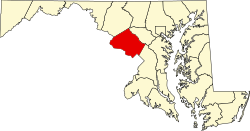
Cloverly is an unincorporated town and census-designated place in Montgomery County, Maryland, United States. Its population was 15,285 as of the 2020 census. [3]
As an unincorporated area, Cloverly's boundaries are not officially defined. Cloverly is, however, recognized by the United States Census Bureau as a census-designated place, and by the United States Geological Survey as a populated place. [4]
According to the United States Census Bureau, the place has a total area of 3.9 square miles (10 km2), all land.
The commercial center of Cloverly lies at the intersection of New Hampshire Avenue (MD Route 650) and Briggs Chaney Road.
Census | Pop. | Note | %± |
---|---|---|---|
2010 | 15,126 | — | |
2020 | 15,285 | 1.1% | |
U.S. Decennial Census [5] 2010–2020 [3] |
Population by Race in Cloverly Maryland (2010) | ||
Race | Population | % of Total |
---|---|---|
Total | 15,126 | 100 |
White | 7,182 | 47 |
African American | 3,848 | 25 |
Asian | 2,745 | 18 |
Hispanic | 1,619 | 10 |
Other | 647 | 4 |
Two or More Races | 646 | 4 |
[6] |
At the 2000 census there were 7,835 people in 2,492 households, including 2,113 families, in the CDP. The population density was 2,004.7 inhabitants per square mile (774.0/km2). There were 2,540 housing units at an average density of 649.9 per square mile (250.9/km2). The racial makeup of the area was 61.52% White, 19.13% African American, 0.40% Native American, 14.05% Asian, 1.98% from other races, and 2.92% from two or more races. Hispanic or Latino of any race were 5.13%. [7]
Of the 2,492 households 43.7% had children under the age of 18 living with them, 71.4% were married couples living together, 9.8% had a female householder with no husband present, and 15.2% were non-families. 12.0% of households were one person and 3.6% were one person aged 65 or older. The average household size was 3.14 and the average family size was 3.41.
The age distribution was 29.0% under the age of 18, 7.4% from 18 to 24, 25.5% from 25 to 44, 29.2% from 45 to 64, and 8.9% 65 or older. The median age was 39 years. For every 100 females, there were 98.0 males. For every 100 females age 18 and over, there were 93.3 males.
The median household income was $82,544 and the median family income was $88,370. Males had a median income of $51,377 versus $40,972 for females. The per capita income for the area was $31,123. About 2.5% of families and 3.4% of the population were below the poverty line, including 3.6% of those under age 18 and none of those age 65 or over.
Montgomery County Public Schools operates public schools.
Public schools for the area include Cloverly Elementary (which lies in the town), Briggs Chaney Middle, and the three high schools of the Northeast Consortium: James Hubert Blake High School, Paint Branch High School, and Springbrook High School. [8]
Only Blake is within the Cloverly CDP. [9]
As of 2019 [update] the community has 32 religious institutions. It includes Christian, Ahmadi Muslim, and Jain institutions. [8]
Milford Mill is an unincorporated community and census-designated place in Baltimore County, Maryland, United States. Per the 2020 census, the population was 30,622.
Clover Hill is an unincorporated community and former census-designated place (CDP) in Frederick County, Maryland, United States. The population was 3,260 at the 2000 census. The area was not listed as a CDP for the 2010 census, and no population total was published.
Green Valley is an unincorporated area and census-designated place (CDP) in southern Frederick County, Maryland, United States. The population was 12,643 at the 2020 census. The area was listed as a census-designated place in 2000 but not listed as part of any CDP at the 2010 census. It was re-designated a census-designated place for the 2020 census.
Ashton-Sandy Spring is a census-designated place (CDP) in Montgomery County, Maryland, United States. The CDP is designated to include the two unincorporated communities of Ashton and Sandy Spring, as well as the smaller community of Brinklow. It had a population of 5,746 as of the 2020 census.
Brookmont is a census-designated place and unincorporated area in Montgomery County, Maryland, United States. As of the 2020 census, it had a population of 3,751. Brookmont is often considered part of neighboring Bethesda because it falls within Bethesda's 20816 zip code.
Fairland is a census-designated place and an unincorporated area in Montgomery County, Maryland, United States. It had a population of 25,396 per the 2020 census.
Montgomery Village is a census-designated place (CDP) in Montgomery County, Maryland, United States, and a northern suburb of Washington, D.C. It is a large, planned suburban community, developed in the late 1960s and 1970s just outside Gaithersburg's city limits. Montgomery Village's population was 34,893 at the time of the 2020 U.S. Census, and it is a part of the Washington metropolitan area.
North Kensington is a census-designated place and an unincorporated area in Montgomery County, Maryland, United States. It had a population of 9,497 in 2020.
Potomac is an unincorporated community and census-designated place in Montgomery County, Maryland, United States. As of the 2020 census, it had a population of 47,018. It is named after the nearby Potomac River. A part of the Washington metropolitan area, many Potomac residents work in nearby Washington, D.C., and Northern Virginia.
Redland is a census-designated place and an unincorporated area in Montgomery County, Maryland, United States. It had a population of 18,592 as of the 2020 census.
East Riverdale is an unincorporated area and census-designated place (CDP) in Prince George's County, Maryland, United States. The population was 18,459 at the 2020 census.
Rosaryville is an unincorporated area and census-designated place (CDP) in Prince George's County, Maryland, United States, located south of Cinton and Upper Marlboro beside U.S. Route 301. Per the 2020 census, the population was 11,548. including housing developments and rural open space. It was named for a local Roman Catholic church. Close to Rosaryville are the Marlton housing development, Maryland Veterans Cemetery, the Southern Maryland Farmers Market, and Rosaryville State Park.
West Laurel is an unincorporated area and census-designated place (CDP) in Prince George's County, Maryland, United States. Per the 2020 census, the population was 4,428.
Covedale is a census-designated place (CDP) in Green Township, Hamilton County, Ohio, United States. The population was 6,472 at the 2020 census. The CDP represents the part of the former village of Covedale that was not annexed by the city of Cincinnati in 1930.
Briggs is an unincorporated community and census-designated place (CDP) in Cherokee County, Oklahoma, United States. The population was 303 at the 2010 census.
Folsom is a census-designated place (CDP) in Delaware County, Pennsylvania, United States. It is part of Ridley Township. The population was 8,323 at the 2010 census.
Three Lakes is a census-designated place (CDP) in Snohomish County, Washington, United States. The population was 3,941 at the 2020 census.
Calverton is an unincorporated area and census-designated place located on the boundary between Montgomery and Prince George's counties, Maryland, in the United States. At the 2020 census, it had a population of 17,316.
Hillandale is an unincorporated area and census-designated place located in Montgomery and Prince George's counties, Maryland, United States. As of the 2020 census, it had a population of 5,774. Hillandale is contained between the Prince George's / Montgomery County line to the east, the Anacostia River to the west, McCeney Avenue to the north, and D.C.'s Capital Beltway to the south. It borders the communities of Adelphi, Avenel, White Oak and Beltsville.
Chevy Chase is a census-designated place (CDP) in Montgomery County, Maryland, United States. The population was 10,176 at the 2020 census.