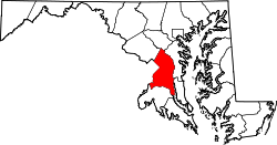
TB, Maryland

Last updated
TB, Maryland
USA Maryland location map.svg
Red pog.svg
TB, Maryland
Location within the state of Maryland
Usa edcp location map.svg
Red pog.svg
TB, Maryland
TB, Maryland (the United States)
Coordinates: 38°42′04″N76°52′28″W / 38.70111°N 76.87444°W / 38.70111; -76.87444 Coordinates: 38°42′04″N76°52′28″W / 38.70111°N 76.87444°W / 38.70111; -76.87444
Country Flag of the United States.svg United States of America
State Flag of Maryland.svg  Maryland
County Flag of Prince George's County, Maryland (1963-present).svg Prince George's
Elevation
236 ft (72 m)
Time zone UTC-5 (Eastern (EST))
  Summer (DST) UTC-4 (EDT)
GNIS feature ID598145

TB is an unincorporated community in Prince George's County, in the U.S. state of Maryland, [1] near the intersection of highways MD 5 and US 301. [2]

History

A post office called T.B. was established in 1860, and remained in operation until 1914. [3] Some say the community has the name of Thomas Brooke, an early settler, [4] [5] while others believe partners William Townshend and Mr. Brooke each etched his respective last initial into stone at the original town site. [4] TB has been noted for its unusually short place name. [6] [7]

Related Research Articles

Interstate 97 (I-97) is a part of the Interstate Highway System that runs entirely within Anne Arundel County, Maryland. The Interstate runs 17.62 miles (28.36 km) from U.S. Route 50 (US 50) and US 301 in Parole near Annapolis north to I-695 and I-895 in Brooklyn Park near Baltimore. The Interstate is the primary highway between Baltimore and Annapolis. I‑97 connects Annapolis with Baltimore–Washington International Airport and links the northern Anne Arundel County communities of Crownsville, Millersville, Severna Park, Glen Burnie, and Ferndale. It is the second shortest primary Interstate Highway after I-87 in North Carolina.

U.S. Route 340 is a spur route of US 40, and runs from Greenville, Virginia to Frederick, Maryland. In Virginia, it runs north–south, parallel and east of US 11, from US 11 north of Greenville via Waynesboro, Grottoes, Elkton, Luray, Front Royal, and Berryville to the West Virginia state line. A short separate piece crosses northern Loudoun County on its way from West Virginia to Maryland.

Maryland Route 450 Highway in Maryland

Maryland Route 450 is a state highway in the U.S. state of Maryland. The state highway runs 30.19 miles (48.59 km) from U.S. Route 1 Alternate in Bladensburg east to US 50, US 301, and MD 2 near Arnold. MD 450 forms a local complement to US 50 from near Washington through Annapolis. In Prince George's County, the highway is a four- to six-lane divided highway that serves Bladensburg, Landover Hills, New Carrollton, Lanham, and Bowie. In Anne Arundel County, MD 450 connects Crofton with Parole and Annapolis with the portion of the county east of the Severn River. The highway serves as one of the main streets of Annapolis, including the state capital's historic core, and is the primary vehicular access to the U.S. Naval Academy.

Maryland Route 3 State highway in Maryland, US

Maryland Route 3, part of the Robert Crain Highway, is the designation given to the former alignment of U.S. Route 301 from Bowie, Maryland, United States, to Baltimore. It is named for Robert Crain of Baltimore. It is unique in Maryland in that it has a business route and a truck route which do not connect to their parent; however, the business route is also a part of the Robert Crain Highway. MD 3's current orientation is vestigial from the construction of Maryland's freeway system.

Maryland Route 5 Highway in Maryland, United States

Maryland Route 5 is a 74.34-mile (119.64 km) long state highway that runs north–south in the U.S. state of Maryland. The highway runs from Point Lookout in St. Mary's County north to the Washington, D.C. border in Suitland, Prince George's County. MD 5 begins as two-lane undivided Point Lookout Road which runs from Point Lookout, St. Mary's County, to an intersection with MD 235 in the northern part of the county. Point Lookout Road passes through rural areas as well as the county seat of Leonardtown. After the MD 235 intersection, the route becomes four-lane divided Three Notch Road and continues into Charles County, where it becomes Leonardtown Road. Here, the route bypasses Hughesville and continues north toward the Waldorf area, which it bypasses to the east on Mattawoman Beantown Road. The route merges onto U.S. Route 301 and enters Prince George's County, splitting from US 301 at an interchange in Brandywine. From here, MD 5 continues north on Branch Avenue, running through suburban areas, before becoming a freeway as it passes Andrews Air Force Base and has an interchange with Interstate 95 (I-95)/I-495. Past the Capital Beltway, the route runs through suburban areas of Hillcrest Heights and Suitland before reaching the D.C. border, where Branch Avenue SE continues, crossing Pennsylvania Avenue SE and eventually terminating at Randle Circle.

U.S. Route 50 is a major east–west route of the U.S. Highway system, stretching just over 3,000 miles (4,800 km) from Ocean City, Maryland on the Atlantic Ocean to West Sacramento, California. In the U.S. state of Maryland, US 50 exists in two sections. The longer of these serves as a major route connecting Washington, D.C. with Ocean City; the latter is the eastern terminus of the highway. The other section passes through the southern end of Garrett County for less than 10 miles (16 km) as part of the Northwestern Turnpike, entering West Virginia at both ends. One notable section of US 50 is the dual-span Chesapeake Bay Bridge across the Chesapeake Bay, which links the Baltimore–Washington metropolitan area with the Eastern Shore region, allowing motorists to reach Ocean City and the Delaware Beaches.

Maryland Route 410 State highway in the U.S. state of Maryland, known for most of its length as East–West Highway

Maryland Route 410 (MD 410) is a state highway in the U.S. state of Maryland and known for most of its length as East–West Highway. The highway runs east to west for 13.92 miles (22.40 km) from MD 355 in Bethesda east to Pennsy Drive in Landover Hills. MD 410 serves as a major east–west commuter route through the inner northern suburbs of Washington, D.C., connecting the commercial districts of Bethesda, Silver Spring, and Hyattsville. In addition, the highway serves the industrial area of Landover Hills and the residential suburbs of Chevy Chase, Takoma Park, Chillum, Riverdale, and East Riverdale. The road also connects many of the arterial highways and freeways that head out of Washington. Additionally, it provides a highway connection to transit and commercial hubs centered around Washington Metro subway stations in Bethesda, Takoma Park, Hyattsville, Silver Spring, and New Carrollton–the latter two of which provide additional connections to MARC and Amtrak trains.

Maryland Route 228 Highway in Maryland

Maryland Route 228 (MD 228) is a state highway in the U.S. state of Maryland. Known as Berry Road, the state highway runs 6.88 miles (11.07 km) from MD 210 in Accokeek east to U.S. Route 301 (US 301) and MD 5 Business in Waldorf. MD 228, which is a four-lane divided highway for its entire length, is a major commuter route between southwestern Prince George's County and northern Charles County. In conjunction with MD 210, the state highway serves as an alternative to US 301 and MD 5 as a route to Washington, D.C. from Southern Maryland. MD 228 also serves as part of the connection, again via MD 210, between Waldorf and Indian Head Naval Surface Warfare Center.

Maryland Route 197 State highway in Maryland, United States, known for most of its length as Laurel Bowie Road

Maryland Route 197 is a state highway in the U.S. state of Maryland. Known for most of its length as Laurel Bowie Road, the state highway runs 14.64 miles (23.56 km) from U.S. Route 301 in Bowie north to MD 198 in Laurel. MD 197 serves as the main connection between Bowie and Laurel in northern Prince George's County. The highway also provides access to Patuxent Wildlife Research Center and Bowie State University. MD 197 also connects US 50 in Bowie and the Baltimore–Washington Parkway in South Laurel with the Bowie State MARC station.

Maryland Route 704 Highway in Maryland, United States

Maryland Route 704 is a state highway in the U.S. state of Maryland. Known as Martin Luther King Jr. Highway, the highway runs 6.53 miles (10.51 km) from Eastern Avenue at the District of Columbia boundary in Seat Pleasant east to MD 450 in Lanham. MD 704 is a four- to six-lane divided highway that connects the northern Prince George's County communities of Seat Pleasant, Landover, Glenarden, and Lanham. The highway was constructed along the right of way of the abandoned Washington, Baltimore and Annapolis Electric Railway (WB&A) in the early 1940s. In the late 1950s and early 1960s, MD 704 served as a temporary routing of U.S. Route 50 while the U.S. Highway's freeway was under construction from Washington to Lanham. The route was expanded to a divided highway between Seat Pleasant and US 50 in the late 1960s and early 1970s. MD 704 was completed as a divided highway when the portion east of US 50 was expanded in the late 1990s.

Maryland Route 725

Maryland Route 725 is a state highway in the U.S. state of Maryland. The state highway runs 1.86 miles (2.99 km) from Brown Station Road east to U.S. Route 301 within Upper Marlboro. MD 725 is the old alignment of MD 4 through the county seat of Prince George's County. What is now MD 725 was constructed in the mid- to late 1910s and became MD 4 in 1927. After MD 4 bypassed Upper Marlboro in the early 1960s, the old highway through town became part of MD 408. After the Prince George's County segments of MD 408 were removed in the late 1970s, the remaining state-maintained highway through Upper Marlboro became MD 725.

U.S. Route 301 (US 301) in the state of Maryland is a major highway that runs from the Governor Harry W. Nice Memorial Bridge over the Potomac River into Virginia northeast to Delaware. It passes through three of Maryland's four main regions: Southern Maryland, the Baltimore-Washington Metropolitan Area, and the Eastern Shore. US 301 serves mainly as a bypass of Baltimore and Washington, D.C. from Virginia to Delaware.

Maryland Route 214

Maryland Route 214 is a state highway in the U.S. state of Maryland. Known for most of its length as Central Avenue, the highway runs 24.97 miles (40.19 km) from Southern Avenue and East Capitol Street at the District of Columbia boundary in Capitol Heights east to Beverley Beach. MD 214 connects the central Prince George's County suburbs of Capitol Heights, Seat Pleasant, Largo, and Bowie with the southern Anne Arundel County communities of Davidsonville and Edgewater and several beach villages along the Chesapeake Bay. The highway connects Interstate 95 (I-95)/I-495 to FedExField, Six Flags America, and several stations of the Washington Metro's Blue and Silver lines, which the route parallels between Capitol Heights and Largo.

Maryland Route 300 Highway in Maryland

Maryland Route 300 is a state highway in the U.S. state of Maryland. Known for most of its length as Sudlersville Road, the highway runs 13.55 miles (21.81 km) from MD 213 in Church Hill east through Sudlersville to the Delaware state line, where the highway continues as Delaware Route 300. MD 300 forms part of an east–west connection between U.S. Route 301 in northern Queen Anne's County and Dover, Delaware. MD 300 between Church Hill and Dudley Corners was one of the original state roads marked for improvement in 1909, but the county constructed the highway with state aid in the mid- to late-1910s from Church Hill to Sudlersville. The highway from Sudlersville to the state line was built in the late 1920s and early 1930s. MD 300 was widened over its entire length around 1950 and extended west to US 213's bypass of Church Hill around 1970. MD 300 was officially split in two when its superstreet intersection with US 301 was built in 2005.

Maryland Route 925

Maryland Route 925 is a state highway in the U.S. state of Maryland. Known as Old Washington Road, the state highway runs 2.49 miles (4.01 km) from Billingsley Road in White Plains north to MD 5 Business in Waldorf. MD 925 and the county-maintained portion of Old Washington Road to the north comprise the old alignment of U.S. Route 301 in northern Charles County. Originally constructed as part of MD 3 and MD 5 in the early 1910s, the highway become part of US 301 in the early 1940s, then was bypassed by the present US 301 divided highway in the mid-1950s. The White Plains–Waldorf portion of the old road was renumbered MD 925 in the early 1960s.

Maryland Route 381

Maryland Route 381 is a state highway in the U.S. state of Maryland. Known as Brandywine Road, the highway runs 15.91 miles (25.60 km) from MD 231 at Patuxent north to U.S. Route 301 in Brandywine. MD 381 connects Brandywine with the southeastern corner of Prince George's County and the northeastern corner of Charles County. The highway was constructed from MD 5 through Brandywine in the 1910s. MD 381 was extended southeast to MD 231 in the late 1920s and early 1930s. When MD 5 was relocated between Camp Springs and Brandywine in the mid-1950s, MD 381 was extended north along the old road to Camp Springs. The highway was rolled back to its present terminus at US 301 in the mid-1960s. The route can serve as an alternate route to the more heavily traveled MD 5 for those wanting to go from St. Mary's, Calvert, and eastern Charles counties to Brandywine.

Maryland Route 382

Maryland Route 382 is a state highway in the U.S. state of Maryland. Known as Croom Road, the highway runs 15.34 miles (24.69 km) from the Charles–Prince George's county line near Aquasco north to U.S. Route 301 in Marlton. MD 382 connects Upper Marlboro with the southeastern corner of Prince George's County and northeastern Charles County. The highway formerly extended west from its southern terminus to Waldorf. MD 382 was built from what is now US 301 south through Croom between the mid-1920s and early 1930s. The highway was extended south and west through Charles County to near Waldorf in the mid-1950s. Part of the extension has been built in the late 1920s as part of MD 233, a parallel highway that extended east to the county line near Aquasco. MD 382 was truncated at the county line to achieve its present length in the late 1980s.

Maryland Route 500 Highway in Maryland

Maryland Route 500 is a state highway in the U.S. state of Maryland. The highway starts at the District of Columbia boundary at Avondale. It is a continuation of Washington D.C.'s Michigan Avenue. As Queens Chapel Road, MD 500 continues north for 2.22 miles (3.57 km) to MD 410 in Hyattsville.

References

  1. U.S. Geological Survey Geographic Names Information System: TB, Maryland
  2. "MD 0005 Branch Avenue US 301 at TB to Auth Road (North of I-95/I-495)". Maryland State Highway Administration. Retrieved October 14, 2015.
  3. "Prince George's County". Jim Forte Postal History. Retrieved 14 October 2015.
  4. 1 2 Fesperman, Dan (March 30, 2001). "A wide spot in the road". The Baltimore Sun. Retrieved 14 October 2015.
  5. Moyer, Armond; Moyer, Winifred (1958). The origins of unusual place-names. Keystone Pub. Associates. p. 129.
  6. International, Rotary (July 1981). The Rotarian. Rotary International. p. 20. ISSN   0035-838X.
  7. Hyde, Henry M. (October 26, 1920). "From Featherbed Lane To Johnnycake Town". The Baltimore Sun . Retrieved April 29, 2022.