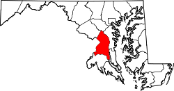
Green Meadows, Maryland

Last updated

Green Meadows
USA Maryland location map.svg
Red pog.svg
Green Meadows
Location within the state of Maryland
Usa edcp location map.svg
Red pog.svg
Green Meadows
Green Meadows (the United States)
Coordinates: 38°58′3″N76°58′43″W / 38.96750°N 76.97861°W / 38.96750; -76.97861
Country Flag of the United States.svg  United States of America
State Flag of Maryland.svg  Maryland
County Flag of Prince George's County, Maryland (1963-present).svg Prince George's
Time zone UTC-5 (Eastern (EST))
  Summer (DST) UTC-4 (EDT)
GNIS feature ID597490

Green Meadows is an unincorporated community in Prince George's County, Maryland, United States. [1] For statistical purposes, it is part of the Chillum census-designated place (CDP). [2]

Contents

Geography

Green Meadows is contained between the Northwest Branch Anacostia River to the east, East West Highway to the north, the Sligo Creek River to the south, and Riggs Road to the west. Green Meadows borders the communities of Hyattsville, Chillum, and Lewisdale. The primary roads that pass through Green Meadows are East West Highway, Ager Road and Riggs Road.

History

The developer-built Green Meadows was platted in the early 1940s and completed by 1942. The street pattern of Green Meadows is a fragmented grid of curved parallel streets. The houses are primarily two-family attached units constructed of brick or brick and frame. The Green Meadows subdivision was extended on its south end by two streets in 1957. The neighborhood is about a mile from the West Hyattsville and Prince George's Plaza stations on the Washington Metro Green Line.

Education

Rosa L. Parks Elementary School (grades pre-k to 6), Prince Georges County Public School System

Parks and recreation

1. Green Meadows Community Park

2. Heurich Community Park

Trails

1. Northwest Branch Trail

2. Sligo Creek Trail

Related Research Articles

<span class="mw-page-title-main">Takoma Park, Maryland</span> City in the United States

Takoma Park is a city in Montgomery County, Maryland, United States. It is a suburb of Washington, and part of the Washington metropolitan area. Founded in 1883 and incorporated in 1890, Takoma Park, informally called "Azalea City", is a Tree City USA and a nuclear-free zone. A planned commuter suburb, it is situated along the Metropolitan Branch of the historic Baltimore and Ohio Railroad, just northeast of Washington, D.C., and it shares a border and history with the adjacent Washington, D.C. neighborhood of Takoma. It is governed by an elected mayor and six elected councilmembers, who form the city council, and an appointed city manager, under a council-manager style of government. The city's population was 17,629 at the 2020 census.

<span class="mw-page-title-main">Adelphi, Maryland</span> Census-designated place in Maryland

Adelphi is an unincorporated area and census-designated place in Prince George's County, Maryland, United States. Per the 2020 Census, the population was 16,823. Adelphi includes the following subdivisions; Adelphi, Adelphi Park, Adelphi Hills, Adelphi Terrace, Adelphi Village, Buck Lodge, Chatham, Cool Spring Terrace, Hillandale Forest, Holly Hill Manor, Knollwood, Lewisdale, and White Oak Manor.

<span class="mw-page-title-main">Chillum, Maryland</span> Census-designated place in Maryland

Chillum is an unincorporated area and census-designated place in Prince George's County, Maryland, United States, bordering Washington, D.C., and Montgomery County.

<span class="mw-page-title-main">Hyattsville, Maryland</span> City in Maryland

Hyattsville is a city in Prince George's County, Maryland, United States, and also a close, urban suburb of Washington, D.C. The population was 21,187 at the 2020 United States Census.

<span class="mw-page-title-main">Langley Park, Maryland</span> Census-designated place in Maryland

Langley Park is an unincorporated area and census-designated place (CDP) in Prince George's County, Maryland, United States. It is located inside the Capital Beltway, on the northwest edge of Prince George's County, bordering Montgomery County. Per the 2020 census, the population was 20,126.

<span class="mw-page-title-main">Sligo Creek</span> Stream in Maryland, United States of America

Sligo Creek is a free-flowing tributary of the Northwest Branch of the Anacostia River in Maryland. The creek is approximately 9.1 miles (14.6 km) long, with a drainage area of about 11.6 square miles (30 km2).

<span class="mw-page-title-main">Maryland Route 650</span> Highway in Maryland, United States

Maryland Route 650 is a state highway in the U.S. state of Maryland. Known as New Hampshire Avenue for most of its length, the state highway runs 25.89 mi (41.67 km) from Eastern Avenue at the Washington, D.C. border north to MD 108 in Etchison. MD 650 serves as a major north-south commuter route in northwestern Prince George's County and eastern Montgomery County, connecting the District of Columbia with the residential suburbs of Takoma Park, Langley Park, Adelphi, Hillandale, White Oak, and Colesville. By contrast, the part of MD 650 north of Spencerville is a quiet rural road connecting several small communities along the northeastern fringe of Montgomery County.

<span class="mw-page-title-main">Maryland Route 410</span> State highway in the U.S. state of Maryland, known for most of its length as East–West Highway

Maryland Route 410 (MD 410) is a state highway in the U.S. state of Maryland and known for most of its length as East–West Highway. The highway runs east to west for 13.92 miles (22.40 km) from MD 355 in Bethesda east to Pennsy Drive in Landover Hills. MD 410 serves as a major east–west commuter route through the inner northern suburbs of Washington, D.C., connecting the commercial districts of Bethesda, Silver Spring, and Hyattsville. In addition, the highway serves the industrial area of Landover Hills and the residential suburbs of Chevy Chase, Takoma Park, Chillum, Riverdale, and East Riverdale. The road also connects many of the arterial highways and freeways that head out of Washington. Additionally, it provides a highway connection to transit and commercial hubs centered around Washington Metro subway stations in Bethesda, Takoma Park, Hyattsville, Silver Spring, and New Carrollton–the latter two of which provide additional connections to MARC and Amtrak trains.

<span class="mw-page-title-main">Maryland Route 501</span>

Maryland Route 501 is a state highway in the U.S. state of Maryland. Known as Chillum Road, the state highway runs 1.68 miles (2.70 km) from MD 212 in Chillum east to MD 500 in Mount Rainier. MD 501, which is the main east–west highway through Chillum in northwestern Prince George's County, was constructed in the early 1930s.

Carole Highlands is an unincorporated community in Prince George's County, Maryland, United States. It is contained between East West Highway to the south, University Boulevard to the north, Larch Avenue, Hopewell Avenue, and 15th Avenue to the west, and Riggs Road to the east. Carole Highlands borders the adjacent neighborhoods of Chillum, Green Meadows, Lewisdale, and Langley Park in Prince George's County, while bordering the city of Takoma Park in Montgomery County. For statistical purposes, it is part of the Langley Park census-designated place (CDP). The community also has a community association and non-profit: Carole Highlands Neighborhood Association

<span class="mw-page-title-main">Sligo Creek Trail</span> Paved hiker/biker trail along Sligo Creek in Maryland

Sligo Creek Trail is a paved hiker-biker trail running along Sligo Creek in the suburbs of Washington, D.C. Most of the trail passes through tree-filled parkland. The trail and surrounding park is a popular place for locals to jog, walk, bicycle, roller-skate, and take their children to the playground. Many local families enjoy picnicking at one of the 15 picnic areas along the trail.

<span class="mw-page-title-main">U.S. Route 1 in Maryland</span> Section of U.S. Route in Maryland, United States

U.S. Route 1 (US 1) is the easternmost and longest of the major north–south routes of the older 1920s era United States Numbered Highway System, running from Key West, Florida, to Fort Kent, Maine. In the U.S. state of Maryland, it runs 81 miles (130 km) from the Washington D.C. line to the Pennsylvania state line near the town of Rising Sun.

<span class="mw-page-title-main">Maryland Route 212</span> State highway in Prince Georges County, Maryland, United States

Maryland Route 212 is a state highway in the U.S. state of Maryland. The highway runs 10.43 miles (16.79 km) from the District of Columbia boundary in Chillum north and east to U.S. Route 1 near Beltsville. MD 212 connects the northern Prince George's County communities of Chillum, Langley Park, Adelphi, Hillandale, Calverton, and Beltsville. The highway was constructed from Washington, D.C. to Adelphi in the early 1910s and extended north through Adelphi to Hillandale in the early 1930s. A separate portion of MD 212 was built from west of US 1 through Beltsville to what is now MD 201 in the early 1930s; the two sections were unified in the early 1940s. The route was expanded to a divided highway south of Langley Park in the early 1960s and at Interstate 95 (I-95) in the early 1970s. MD 212's eastern terminus was relocated north of Beltsville after a series of county highways were upgraded and brought into the state highway system in the 2000s and early 2010s; the old highway through Beltsville to MD 201 became MD 212A.

Avondale is an unincorporated community in Prince George's County Maryland, United States. It is contained between Eastern Avenue NE to the south, Queens Chapel Road (MD-500) to the east, and the Northwest Branch Anacostia River to the north and west.

Lewisdale is an unincorporated community in Prince George's County, Maryland, United States. For statistical purposes, it is considered part of the Chillum census-designated place (CDP). Lewisdale is a neighborhood contained between the Northwest Branch Anacostia River to the east, East West Highway to the south, University Boulevard to the north, and Riggs Road to the west.

<span class="mw-page-title-main">Northwest Branch Anacostia River</span> Anacostia River tributary in Maryland, U.S.

Northwest Branch Anacostia River is a 21.5-mile-long (34.6 km) free-flowing stream in Montgomery County and Prince George's County, Maryland. It is a tributary of the Anacostia River, which flows to the Potomac River and the Chesapeake Bay.

<span class="mw-page-title-main">Anacostia Tributary Trail System</span> Hiking trail in Maryland

The Anacostia Tributary Trail System (ATTS) is a unified and signed system of stream valley trails joining trails along the Anacostia tributaries of Northwest Branch, Northeast Branch, Indian Creek and Paint Branch with a trail along the Anacostia River, set aside and maintained by the Maryland-National Capital Park and Planning Commission (M-NCPPC) in the Maryland suburbs of Washington, D.C.

<span class="mw-page-title-main">Maryland Route 500</span> Highway in Maryland

Maryland Route 500 is a state highway in the U.S. state of Maryland. The highway starts at the District of Columbia boundary at Avondale. It is a continuation of Washington D.C.'s Michigan Avenue. As Queens Chapel Road, MD 500 continues north for 2.22 miles (3.57 km) to MD 410 in Hyattsville.

<span class="mw-page-title-main">Maryland Route 320</span>

Maryland Route 320 is a state highway in the U.S. state of Maryland. Known as Piney Branch Road, the highway runs 2.84 miles (4.57 km) from Eastern Avenue at the District of Columbia boundary in Takoma Park north to MD 650 in Adelphi. MD 320 is a southwest–northeast highway that connects Takoma Park and Silver Spring in southeastern Montgomery County with Adelphi in far western Prince George's County. The state highway originally extended from downtown Silver Spring to White Oak and connected with U.S. Route 29 at both ends. The Silver Spring–Adelphi portion of the highway was constructed in 1910. The segment through Takoma Park and the Adelphi–White Oak segment, which later became MD 650, were built in the early 1930s; the Takoma Park portion was built as MD 513. MD 320 was widened over its whole length in the late 1940s and reduced to its present course in the mid-1950s.

<span class="mw-page-title-main">New Carrollton–Fort Totten Line</span> Bus route in Washington, D.C. region

The New Carrollton–Fort Totten Line, designated Route F6, is a weekday-only bus route operated by the Washington Metropolitan Area Transit Authority between the New Carrollton station of the Orange Line station of the Washington Metro and the Fort Totten station of the Red and Green Lines of the Washington Metro. The line operates every 30 minutes during peak hours and 60 minutes all other times, weekdays only. F6 trips are roughly 60 minutes. This route provides weekday service between Fort Totten and New Carrollton stations without having to take the train into Downtown DC.

References

  1. U.S. Geological Survey Geographic Names Information System: Green Meadows, Maryland
  2. "Prince George's County, MD: Census Incorporated Places & Census Designated Places" (PDF). Prince George's County Map. Maryland Department of Planning. January 29, 2009. Archived from the original (PDF) on October 29, 2008. Retrieved January 29, 2009.