Temple Hills, Maryland | |
---|---|
Coordinates: 38°48′38″N76°56′47″W / 38.81056°N 76.94639°W | |
Country | United States |
State | Maryland |
County | Prince George's |
Area | |
• Total | 1.41 sq mi (3.65 km2) |
• Land | 1.41 sq mi (3.65 km2) |
• Water | 0.00 sq mi (0.00 km2) |
Elevation | 269 ft (82 m) |
Population (2020) | |
• Total | 8,350 |
• Density | 5,930.40/sq mi (2,290.19/km2) |
Time zone | UTC−5 (Eastern (EST)) |
• Summer (DST) | UTC−4 (EDT) |
Area code(s) | 301, 240 |
FIPS code | 24-77100 |
GNIS feature ID | 0598158 |
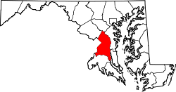
Temple Hills is an unincorporated area and census-designated place (CDP) in Prince George's County, Maryland, United States. [2] Temple Hills borders the communities of Hillcrest Heights, Marlow Heights, Camp Springs and Oxon Hill. Per the 2020 census, the population was 8,350. [3]
The community was named after Edward Temple, who in the 1860s lived in a home beside Henson Creek known as Moor Park. [4] Within the area are numerous garden apartments, duplexes, and single family communities constructed mostly from the 1950s through 1970s. The adjacent, unincorporated communities of Hillcrest Heights and Marlow Heights, which are home to both the Iverson Mall & Marlow Heights Shopping Center, which both serve the community of Temple Hills, are assigned Temple Hills addresses and zipcodes.
Rosecroft Raceway (since 1949, harness horse racing) is nearby in Oxon Hill, although the racing audience has declined greatly. There are large public indoor and outdoor swimming pools operated by the Maryland-National Capital Park and Planning Commission, and also the private Temple Hills Swim Club. The area is especially convenient to the Capital Beltway (I-95/I-495), the Metrorail Green Line, Andrews Air Force Base, the U.S. Census Bureau, and Capitol Hill.
Since the clogged interstate Woodrow Wilson Bridge was widened in 2008, commuter access to Northern Virginia's job market has improved.
Temple Hills is located at 38°48′38″N76°56′47″W / 38.81056°N 76.94639°W (38.810580, −76.946360). [5]
According to the United States Census Bureau, the CDP has a total area of 1.4 square miles (3.6 km2), all land.
Census | Pop. | Note | %± |
---|---|---|---|
1980 | 6,630 | — | |
1990 | 6,865 | 3.5% | |
2000 | 7,792 | 13.5% | |
2010 | 7,852 | 0.8% | |
2020 | 8,350 | 6.3% | |
U.S. Decennial Census [6] 2010 [7] 2020 [8] |
Race / Ethnicity (NH = Non-Hispanic) | Pop 2010 [7] | Pop 2020 [8] | % 2010 | % 2020 |
---|---|---|---|---|
White alone (NH) | 332 | 315 | 4.23% | 3.77% |
Black or African American alone (NH) | 6,748 | 6,833 | 85.94% | 81.83% |
Native American or Alaska Native alone (NH) | 19 | 14 | 0.24% | 0.17% |
Asian alone (NH) | 94 | 120 | 1.20% | 1.44% |
Pacific Islander alone (NH) | 2 | 1 | 0.03% | 0.01% |
Some Other Race alone (NH) | 15 | 24 | 0.19% | 0.29% |
Mixed Race or Multi-Racial (NH) | 158 | 225 | 2.01% | 2.69% |
Hispanic or Latino (any race) | 484 | 818 | 6.16% | 9.80% |
Total | 7,852 | 8,350 | 100.00% | 100.00% |
At the 2000 census, [9] there were 7,792 people, 3,156 households and 1,937 families residing in the CDP. The population density was 5,756.1 inhabitants per square mile (2,222.4/km2). There were 3,388 housing units at an average density of 2,502.8 per square mile (966.3/km2). The racial makeup of the CDP was 9.32% White, 85.01% African American, 0.21% Native American, 1.40% Asian, 0.15% Pacific Islander, 2.37% from other races, and 1.54% from two or more races. Hispanic or Latino of any race were 4.39% of the population.
There were 3,156 households, of which 36.7% had children under the age of 18 living with them, 28.8% were married couples living together, 27.1% had a female householder with no husband present, and 38.6% were non-families. 32.3% of all households were made up of individuals, and 3.2% had someone living alone who was 65 years of age or older. The average household size was 2.47 and the average family size was 3.11.
Age distribution was 29.6% under the age of 18, 10.2% from 18 to 24, 37.0% from 25 to 44, 18.3% from 45 to 64, and 4.9% who were 65 years of age or older. The median age was 30 years. For every 100 females, there were 82.9 males. For every 100 females age 18 and over, there were 74.2 males.
The median household income was $44,868 and the median family income was $49,318. Males had a median income of $35,192 compared with $32,500 for females. The per capita income for the CDP was $21,939. About 9.9% of families and 10.4% of the population were below the poverty line, including 16.4% of those under age 18 and 2.9% of those age 65 or over.
Prince George's County Police Department District 4 Station in Glassmanor CDP, with an Oxon Hill postal address, serves the community. [10]
The United States Postal Service operates the Temple Hills Post Office in the Marlow Heights CDP, with a Temple Hills postal address. [11] It also operates the Anacostia Carrier Annex in the Hillcrest Heights CDP, also with a Temple Hills postal address. [12]
The CDP is served by the Prince George's County Public Schools district. [13]
Samuel Chase and J. Frank Dent elementaries serve sections of the CDP. [14] All residents of the CDP are zoned to Thurgood Marshall Middle School, [15] and Crossland High School. [16] Crossland High is physically in Camp Springs CDP and has a Temple Hills postal address. [17]
Camp Springs is an unincorporated area and census-designated place (CDP) in Prince George's County, Maryland, United States. The population was 22,734 at the 2020 census. Camp Springs is not an official post office designation; the area is divided among the surrounding mailing addresses of Temple Hills, Fort Washington, Clinton, and Suitland.
Coral Hills is an unincorporated area and census-designated place (CDP) in Prince George's County, Maryland, United States. As of the 2020 census, the population was 9,997.
Forest Heights is a town in Prince George's County, Maryland, United States, and is part of the larger postal designation of Oxon Hill. The town straddles both sides of dual-lane Maryland Route 210 and includes two elementary schools. Per the 2020 census, the population was 2,658.
Fort Washington is an unincorporated area and census-designated place in Prince George's County, Maryland, United States. It borders the Potomac River, situated 20 miles south of downtown Washington, D.C. As of the 2020 census, it had a population of 24,261. The Fort Washington community is located west of Maryland Route 210, with some additional area to the east of the highway.
Hillcrest Heights is an unincorporated area and census-designated place (CDP) in Prince George's County, Maryland, United States. The population was 15,793 at the 2020 census. For mailing address purposes, it is part of the smaller community of Temple Hills and is also near Suitland.
Kettering is an unincorporated area and census-designated place in Prince George's County, Maryland, United States. At the 2020 United States Census, the population was 14,424,. Kettering is adjacent to Prince George's Community College, the upscale gated community of Woodmore, Six Flags America, Evangel Temple megachurch, and the community of Largo at the end of the Washington Metro Blue Line. Watkins Regional Park in Kettering offers a large playground, a colorful carousel, miniature golf, a miniature train ride, and various animals.
Largo, located within Greater Upper Marlboro, Maryland, is an unincorporated area and census-designated place in Prince George's County, Maryland, United States. The population was 11,605 at the 2020 census.
Marlow Heights is an unincorporated area and census-designated place (CDP) in Prince George's County, Maryland, United States. The population was 6,169 at the 2020 census. The Marlow Heights Shopping Center first opened in 1957, adjacent to the large community of Hillcrest Heights. It was joined ten years later, in 1967, by the two-level Iverson Mall, the Washington metropolitan area's first enclosed mall.
Morningside is an incorporated town in Prince George's County, Maryland, United States. Per the 2020 census, the population was 1,240. The town developed with the establishment of nearby Andrews Air Force Base and the federal Census Bureau. The government of the town is led by a mayor and town council. Morningside Elementary School and Benjamin Foulois Junior High School/Elementary/Creative and Performing Arts Academy (current) as well as Michael J Polley Neighborhood Park are located within the town limits. Morningside has one of the largest VFW posts (chapters) in the entire country. Morningside is also the city of license of one of Washington's most prominent radio stations, from the 1960s to the present, WJFK and WPGC-FM. Additionally, Morningside is home to one of the busiest volunteer fire departments in Prince George's County, Morningside VFD Station 827. In 2015, station 827 ran over 8,000 calls for service with 150 working fires in Morningside and the adjacent communities, and has garnered national recognition for their service to the community.
Walker Mill is an unincorporated area and census-designated place (CDP) in Prince George's County, Maryland, United States. Per the 2020 census, the population was 12,187.
Calverton is an unincorporated area and census-designated place located on the boundary between Montgomery and Prince George's counties, Maryland, in the United States. At the 2020 census, it had a population of 17,316.
Landover is an unincorporated community and census-designated place in Prince George's County, Maryland, United States. As of the 2020 census, it had a population of 25,998.
Lanham is an unincorporated community and census-designated place in Prince George's County, Maryland. As of the 2020 United States Census it had a population of 11,282. The New Carrollton station as well as an Amtrak station are across the Capital Beltway in New Carrollton, Maryland. Doctors Community Hospital is located in Lanham.
Peppermill Village is an unincorporated community near Maryland Route 214 in Prince George's County, Maryland, United States. Per the 2020 census, the population was 5,264. FedExField, Metrorail's Blue Line, and Hampton Mall shopping center are all located nearby. Because it is not formally incorporated, it has no official boundaries, but the United States Census Bureau has defined a census-designated place (CDP) consisting of Peppermill Village and the adjacent community of Carmody Hills, for statistical purposes.
Oxon Hill is an unincorporated area and census-designated place (CDP) in southern Prince George's County, Maryland, United States. Oxon Hill is a suburb of Washington, located southeast of the downtown district and east of Alexandria, Virginia. Since 2008, it contains the 300-acre (120 ha) National Harbor development on the shore of the Potomac River.
Glassmanor is an unincorporated community and census-designated place in Prince George's County, Maryland, United States. As of the 2020 census, it had a population of 18,430. In the 1990 and 2000 censuses, the United States Census Bureau had placed Glassmanor and the adjacent community of Oxon Hill in the "Oxon Hill-Glassmanor" census-designated place for statistical purposes. Glassmanor was last delineated separately in 1980, when the CDP recorded a population of 7,751.
Suitland is a suburb of Prince George's County, Maryland, approximately one mile (1.6 km) southeast of Washington, D.C. Suitland is a census designated place (CDP), as of the 2020 census, its population was 25,839. Prior to 2010, it was part of the Suitland-Silver Hill census-designated place.
Silver Hill is an unincorporated community and census-designated place (CDP) in Prince George's County, Maryland, United States, approximately 1 mile (1.6 km) southeast of Washington, D.C. Per the 2020 census, the population was 6,381. Prior to 2010, Silver Hill was part of the Suitland-Silver Hill census-designated place.
Crossland High School is a public secondary school located in Camp Springs census-designated place, unincorporated Prince George's County, Maryland, with Temple Hills postal address. The school serves about 2,000 students in grades 9 to 12 in the Prince George's County Public Schools system.
Potomac High School is a public high school located in the Glassmanor census-designated place in unincorporated Prince George's County, Maryland, United States, with an Oxon Hill postal address. It is a part of Prince George's County Public Schools.