Nelson, Georgia

Last updated
Nelson, Georgia
Nelson Georgia city hall.jpg
Nelson city hall
Pickens County Georgia Incorporated and Unincorporated areas Nelson Highlighted.svg
Location in Pickens County and the state of Georgia
Coordinates: 34°22′54″N84°22′17″W / 34.38167°N 84.37139°W / 34.38167; -84.37139 Coordinates: 34°22′54″N84°22′17″W / 34.38167°N 84.37139°W / 34.38167; -84.37139
Country United States
State Georgia
Counties Pickens, Cherokee
Area
[1]
  Total1.53 sq mi (3.97 km2)
  Land1.52 sq mi (3.95 km2)
  Water0.01 sq mi (0.02 km2)
Elevation
1,237 ft (377 m)
Population
 (2020)
  Total1,145
  Density751.31/sq mi (290.11/km2)
Time zone UTC-5 (Eastern (EST))
  Summer (DST) UTC-4 (EDT)
ZIP code
30151
Area code 770
FIPS code 13-54572 [2]
GNIS feature ID0319244 [3]

Nelson is a city in Pickens and Cherokee Counties, Georgia, United States. At the 2020 census, the population was 1,145. It is part of the Atlanta metropolitan area.

Contents

History

The city is named for John Nelson, an early landowner, farmer, and rifle maker. [4] The Georgia General Assembly incorporated Nelson as a town in 1891. [5]

The area possesses substantial deposits of marble. The construction of a railway in 1883 made the development of large-scale quarries possible. The quality of the marble has made it favored for federal monuments. [6]

On April 1, 2013, the city council voted unanimously to approve the "Family Protection Ordinance". Every head of household must own a gun and ammunition to "provide for the emergency management of the city" and to "provide for and protect the safety, security, and general welfare of the city and its inhabitants." Residents are not required to buy one if they do not have one, and the ordinance does not penalize anyone who does not comply. Convicted felons are exempt. [7]

Geography

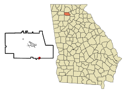
Nelson is located on the border of Pickens and Cherokee Counties at 34°22′54″N84°22′17″W / 34.38167°N 84.37139°W / 34.38167; -84.37139 (34.381562, -84.371303). [8] The original city center is located in Pickens County, but the city limits have recently expanded southward so that more of the city is now located in Cherokee County.

According to the United States Census Bureau, the city has a total area of 1.5 square miles (3.8 km2), of which 0.008 square miles (0.02 km2), or 0.56%, is covered by water. [9]

Nelson is served through its downtown by the Georgia Northeastern Railroad, and by Canton Road, the town's main street and the former route of Georgia State Route 5. South on old 5 is Ball Ground, and north is Tate. The north end of Interstate 575 and south end of State Route 515 are at the county line just to the west of Nelson. I-575 leads south 52 miles (84 km) to Atlanta, and SR 515 leads north 26 miles (42 km) to Ellijay.

Demographics

Historical population
CensusPop.
1890 266
1900 254−4.5%
1910 550116.5%
1920 511−7.1%
1930 79856.2%
1940 679−14.9%
1950 645−5.0%
1960 6582.0%
1970 613−6.8%
1980 562−8.3%
1990 486−13.5%
2000 62628.8%
2010 1,314109.9%
2020 1,145−12.9%
U.S. Decennial Census [10]

2020 census

Nelson racial composition [11]
RaceNum.Perc.
White (non-Hispanic)1,01888.91%
Black or African American (non-Hispanic)282.45%
Native American 30.26%
Asian 20.17%
Other/Mixed 464.02%
Hispanic or Latino 484.19%

As of the 2020 United States census, there were 1,145 people, 523 households, and 383 families residing in the city.

2000 census

As of the census [2] of 2000, 626 people, 254 households, and 188 families resided in the city. The population density was 695.0 inhabitants per square mile (268.3/km2). The 275 housing units averaged 305.3 per square mile (118.0/km2). The racial makeup of the city was 89.94% White, 9.42% African American, 0.16% Native American, 0.16% Asian, and 0.32% from two or more races. Hispanics or Latinos of any race were 0.16% of the population.

Of the 254 households, 27.2% had children under the age of 18 living with them, 64.2% were married couples living together, 8.3% had a female householder with no husband present, and 25.6% were not families. About 22.4% of all households were made up of individuals, and 10.6% had someone living alone who was 65 years of age or older. The average household size was 2.46 and the average family size was 2.88.

In the city, the population was distributed as 19.3% under the age of 18, 7.7% from 18 to 24, 28.9% from 25 to 44, 27.2% from 45 to 64, and 16.9% who were 65 years of age or older. The median age was 42 years. For every 100 females, there were 93.2 males. For every 100 females age 18 and over, there were 90.6 males.

The median income for a household in the city was $44,250, and for a family was $51,806. Males had a median income of $35,066 versus $30,450 for females. The per capita income for the city was $20,604. About 1.1% of families and 3.7% of the population were below the poverty line, including 1.1% of those under age 18 and 8.5% of those age 65 or over.

The estimated median household income in 2008 was $56,361, compared to $50,861 for the state of Georgia. The estimated per capita income in 2008 was $26,140.

The estimated median house or condominium value in 2008 was $208,186, compared to $169,100 for the state of Georgia. The estimated median home value in Nelson was $110,800 in 2000. In 2008, the mean price for all housing units was $204,682, for detached houses $212,211, for townhouses or other attached units $147,212, and for mobile homes $54,519.[ citation needed ]


Notable person

Related Research Articles

<span class="mw-page-title-main">Oconee County, South Carolina</span> County in South Carolina, United States

Oconee County is the westernmost county in the U.S. state of South Carolina. As of the 2020 census, the population was 78,607. Its county seat is Walhalla and its largest city is Seneca. Oconee County is included in the Seneca, SC Micropolitan Statistical Area, which is also included in the Greenville-Spartanburg-Anderson, SC Combined Statistical Area. South Carolina Highway 11, the Cherokee Foothills National Scenic Highway, begins in southern Oconee County at Interstate Highway 85 at the Georgia state line.

<span class="mw-page-title-main">Union County, Georgia</span> County in Georgia, United States

Union County is a county located in the north central portion of the U.S. state of Georgia. As of the 2010 census, the population was 21,356. The county seat is Blairsville.

<span class="mw-page-title-main">Pickens County, Georgia</span> County in Georgia, United States

Pickens County is a county located in the north-central portion of the U.S. state of Georgia. As of the 2010 census, the population was 29,431. The county seat is Jasper. Pickens County is part of the Atlanta-Sandy Springs-Roswell, Georgia metropolitan statistical area.

<span class="mw-page-title-main">Murray County, Georgia</span> County in Georgia, United States

Murray County is a county located in the northwestern part of the U.S. state of Georgia. As of the 2010 census, the population was 39,628. The county seat is Chatsworth.

<span class="mw-page-title-main">Gordon County, Georgia</span> County in Georgia, United States

Gordon County is a county located in the northwestern part of the U.S. state of Georgia. As of the 2010 census, the population was 55,186. The county seat is Calhoun. Gordon County comprises the Calhoun, GA Micropolitan Statistical Area, which is included in the Atlanta-Athens-Clarke County-Sandy Springs, GA Combined Statistical Area.

<span class="mw-page-title-main">Gilmer County, Georgia</span> County in Georgia, United States

Gilmer County is a county located in the north central portion of the U.S. state of Georgia. As of the 2010 census, the population was 28,292. The county seat is Ellijay. It was based on a historic Cherokee town also spelled as Elejoy in the eighteenth century. The county was created on December 3, 1832 and was named for George Rockingham Gilmer, a politician who served two non-consecutive terms as governor of the state. Gilmer County is home of the annual Apple Festival, which is held in mid-October. Ninety percent of the land is in cropland and forest. Poultry raising and processing makes up the largest portion of the agricultural economy, which generates 33.2% of the total revenues. Manufacturing is about 20%.

<span class="mw-page-title-main">Fannin County, Georgia</span> County in Georgia, United States

Fannin County is a county located in the north central portion of the U.S. state of Georgia. As of the 2010 census, the population was 23,682. It is one of the most rural counties in Georgia due its location in the Appalachian Mountain Range, with about 90% of the population of Fannin County living in unincorporated lands. The county seat is Blue Ridge. The county was created on January 21, 1854 and is named after James Fannin, a veteran who fought in the Texas Revolution.

<span class="mw-page-title-main">Dawson County, Georgia</span> County in Georgia, United States

Dawson County is a county located in the north-central portion of the U.S. state of Georgia. As of the 2010 census, the population was 22,330. The county seat is Dawsonville.

<span class="mw-page-title-main">Cherokee County, Georgia</span> County in Georgia, United States

Cherokee County is located in the US state of Georgia. As of 2019 estimates, the population was 258,773. The county seat is Canton. The county Board of Commissioners is the governing body, with members elected to office. Cherokee County is included in the Georgia Metropolitan Area.

<span class="mw-page-title-main">Bartow County, Georgia</span> County in Georgia, United States

Bartow County is located in the northwestern part of the U.S. state of Georgia. As of the 2010 census, the population was 100,157. The county seat is Cartersville.

<span class="mw-page-title-main">Holly Springs, Georgia</span> City in Georgia, United States

Holly Springs is a city in Cherokee County, Georgia, United States. The population was 9,189 as of the 2010 census, up from 3,195 in 2000.

<span class="mw-page-title-main">Waleska, Georgia</span> City in Georgia, United States

Waleska is a city in Cherokee County, Georgia, United States. The population was 644 at the 2010 census.

<span class="mw-page-title-main">Morganton, Georgia</span> City in Georgia, United States

Morganton is a city in Fannin County, Georgia, United States. The population was 303 at the 2010 census.

<span class="mw-page-title-main">Fairmount, Georgia</span> City in Georgia, United States

Fairmount is a city in Gordon County, Georgia, United States. As of the 2010 census it had a population of 720. Gordon County is home to New Echota, which was once the Cherokee Nation's capital. It was the origin of the Cherokee written language and newspaper, the Cherokee Phoenix.

<span class="mw-page-title-main">Hampton, Georgia</span> City in Georgia, United States

Hampton is a city in southwestern Henry County, Georgia, United States. As of the 2010 census, the city had a population of 6,987, up from 3,857 at the 2000 census. By 2018 the estimated population was 7,922. "Hampton" mailing addresses outside the city limits reach into rural parts of eastern Clayton County and northern Spalding County. It is a southeastern suburb in the Atlanta metropolitan area.

<span class="mw-page-title-main">Jasper, Georgia</span> City and county seat in Georgia, United States

Jasper is a city in Pickens County, Georgia, United States. The population was 3,684 at the 2010 census. The city is the county seat of Pickens County.

<span class="mw-page-title-main">Talking Rock, Georgia</span> Town in Georgia, United States

Talking Rock is a town in Pickens County, Georgia, United States. The population is 91.

<span class="mw-page-title-main">Pickens, South Carolina</span> City in South Carolina, United States

Pickens, formerly called Pickens Courthouse, is a city in Pickens County, South Carolina, United States. The population was 3,126 at the 2010 census. Pickens changed its classification from a town to a city in 1998, but it was not reported to the Census Bureau until 2001. It is the county seat of Pickens County. It was named after Andrew Pickens (1739–1817), an American revolutionary soldier and US Congressman for South Carolina.

<span class="mw-page-title-main">Kilmarnock, Virginia</span> Town in Virginia, United States

Kilmarnock is a town in Lancaster and Northumberland counties in the U.S. Commonwealth of Virginia. The population was 1,487 at the 2010 census. It is located near the mouth of the Rappahannock River and is located within the Northern Neck George Washington Birthplace American Viticultural Area winemaking appellation. There is a small hospital in the town. Lancaster Middle School, grades 4–8, is also located in town. Approximately 500 students attend the school.

<span class="mw-page-title-main">Mountain Park, Fulton County, Georgia</span> City in Georgia, United States

Mountain Park is a city primarily in the western part of northern Fulton County in the U.S. state of Georgia, with a small portion extending less than 1,000 feet (300 m) into southeastern Cherokee County. As of the 2020 census, the city had a total population of 583.

References

  1. "2020 U.S. Gazetteer Files". United States Census Bureau. Retrieved December 18, 2021.
  2. 1 2 "U.S. Census website". United States Census Bureau . Retrieved 2008-01-31.
  3. "US Board on Geographic Names". United States Geological Survey. 2007-10-25. Retrieved 2008-01-31.
  4. U.S. Geological Survey Geographic Names Information System: Nelson, Georgia
  5. Acts Passed by the General Assembly of Georgia. J. Johnston. 1892. p. 742.
  6. "About Nelson - Welcome to Nelson, Georgia". www.nelsongeorgia.com. Retrieved 2017-03-17.
  7. "GA. City Council Votes to Require Gun Ownership". AP. Retrieved 2 April 2013.
  8. "US Gazetteer files: 2010, 2000, and 1990". United States Census Bureau. 2011-02-12. Retrieved 2011-04-23.
  9. "Geographic Identifiers: 2010 Demographic Profile Data (G001): Nelson city, Georgia". U.S. Census Bureau, American Factfinder. Archived from the original on February 12, 2020. Retrieved July 24, 2014.
  10. "Census of Population and Housing". Census.gov. Retrieved June 4, 2015.
  11. "Explore Census Data". data.census.gov. Retrieved 2021-12-14.