Holly Springs, Georgia

Last updated
Holly Springs, Georgia
Holly Springs, Georgia train depot.jpg
Holly Springs train depot
Cherokee County Georgia Incorporated and Unincorporated areas Holly Springs Highlighted.svg
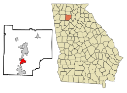
Location in Cherokee County and the state of Georgia
USA Georgia location map.svg
Red pog.svg
Holly Springs, Georgia
Usa edcp location map.svg
Red pog.svg
Holly Springs, Georgia
Metro atlanta.jpg
Red pog.svg
Holly Springs, Georgia
Coordinates: 34°9′59″N84°30′4″W / 34.16639°N 84.50111°W / 34.16639; -84.50111 Coordinates: 34°9′59″N84°30′4″W / 34.16639°N 84.50111°W / 34.16639; -84.50111
Country United States
State Georgia
County Cherokee
Area
[1]
  Total7.29 sq mi (18.88 km2)
  Land7.19 sq mi (18.62 km2)
  Water0.10 sq mi (0.26 km2)
Elevation
1,109 ft (338 m)
Population
 (2020)
  Total16,213
  Density2,254.94/sq mi (870.68/km2)
Time zone UTC-5 (Eastern (EST))
  Summer (DST) UTC-4 (EDT)
ZIP code
30142
Area code(s) 770/678/470
FIPS code 13-39524 [2]
GNIS feature ID0315567 [3]
Website www.hollyspringsga.us

Holly Springs is a city in Cherokee County, Georgia, United States. The population was 9,189 as of the 2010 census, [4] up from 3,195 in 2000.

Contents

History

The Georgia General Assembly incorporated the place in 1906 as the Town of Holly Springs. [5] According to tradition, the city was named from a stand of holly trees near a spring at the original town site. [6]

Geography

Holly Springs is located south of the center of Cherokee County at 34°9′59″N84°30′4″W / 34.16639°N 84.50111°W / 34.16639; -84.50111 (34.166478, -84.501016). [7] It is bordered by Canton, the county seat, to the north, and by Woodstock to the south. Interstate 575 passes through the city, with access from exits 11 and 14. Downtown Atlanta is 36 miles (58 km) to the south.

According to the United States Census Bureau, Holly Springs has a total area of 6.7 square miles (17.3 km2), of which 6.6 square miles (17.0 km2) is land and 0.12 square miles (0.3 km2), or 1.57%, is water. [4]

Neighboring unincorporated communities

Demographics

Historical population
CensusPop.
1910 251
1920 216−13.9%
1930 27326.4%
1940 256−6.2%
1950 38650.8%
1960 47523.1%
1970 57521.1%
1980 68719.5%
1990 2,406250.2%
2000 3,19532.8%
2010 9,189187.6%
2020 16,21376.4%
U.S. Decennial Census [8]

2020 census

Holly Springs racial composition [9]
RaceNum.Perc.
White (non-Hispanic)12,15274.95%
Black or African American (non-Hispanic)1,1507.09%
Native American 320.2%
Asian 4192.58%
Pacific Islander 30.02%
Other/Mixed 8705.37%
Hispanic or Latino 1,5879.79%

As of the 2020 United States census, there were 16,213 people, 4,145 households, and 3,205 families residing in the city.

2000 census

As of the census [2] of 2000, there were 3,195 people, 1,136 households, and 892 families residing in the city. The population density was 1,008.5 inhabitants per square mile (389.4/km2). There were 1,173 housing units at an average density of 370.3 per square mile (143.0/km2). The racial makeup of the city was 94.80% White, 1.16% African American, 0.66% Native American, 0.75% Asian, 0.03% Pacific Islander, 1.44% from other races, and 1.16% from two or more races. Hispanic or Latino of any race were 4.82% of the population.

There were 1,136 households, out of which 45.6% had children under the age of 18 living with them, 66.9% were married couples living together, 7.7% had a female householder with no husband present, and 21.4% were non-families. 16.3% of all households were made up of individuals, and 3.3% had someone living alone who was 65 years of age or older. The average household size was 2.81 and the average family size was 2.16.

In the city, the population was spread out, with 30.1% under the age of 18, 7.3% from 18 to 24, 40.8% from 25 to 44, 16.7% from 45 to 64, and 5.0% who were 65 years of age or older. The median age was 31 years. For every 100 females, there were 103.1 males. For every 100 females age 18 and over, there were 111.2 males.

The median income for a household in the city was $57,019, and the median income for a family was $61,651. Males had a median income of $40,717 versus $26,823 for females. The per capita income for the city was $22,992. About 0.8% of families and 1.3% of the population were below the poverty line, including 1.6% of those under age 18 and none of those age 65 or over.


Related Research Articles

<span class="mw-page-title-main">Cherokee County, Alabama</span> County in Alabama, United States

Cherokee County, Alabama is a county located in the northeastern part of the U.S. state of Alabama. As of the 2020 census, the population was 24,971. Its county seat is Centre. The county is named for the Cherokee tribe.

<span class="mw-page-title-main">Seminole County, Georgia</span> County in Georgia, United States

Seminole County is a county located in the southwestern corner of U.S. state of Georgia. As of the 2010 census, the population was 8,729. The county seat is Donalsonville.

<span class="mw-page-title-main">Pickens County, Georgia</span> County in Georgia, United States

Pickens County is a county located in the north-central portion of the U.S. state of Georgia. As of the 2010 census, the population was 29,431. The county seat is Jasper. Pickens County is part of the Atlanta-Sandy Springs-Roswell, Georgia metropolitan statistical area.

<span class="mw-page-title-main">Murray County, Georgia</span> County in Georgia, United States

Murray County is a county located in the northwestern part of the U.S. state of Georgia. As of the 2010 census, the population was 39,628. The county seat is Chatsworth.

<span class="mw-page-title-main">Gordon County, Georgia</span> County in Georgia, United States

Gordon County is a county located in the northwestern part of the U.S. state of Georgia. As of the 2010 census, the population was 55,186. The county seat is Calhoun. Gordon County comprises the Calhoun, GA Micropolitan Statistical Area, which is included in the Atlanta-Athens-Clarke County-Sandy Springs, GA Combined Statistical Area.

<span class="mw-page-title-main">Cherokee County, Georgia</span> County in Georgia, United States

Cherokee County is located in the US state of Georgia. As of 2019 estimates, the population was 258,773. The county seat is Canton. The county Board of Commissioners is the governing body, with members elected to office. Cherokee County is included in the Georgia Metropolitan Area.

<span class="mw-page-title-main">Nelson, Georgia</span> City in Georgia, United States

Nelson is a city in Pickens and Cherokee Counties, Georgia, United States. At the 2020 census, the population was 1,145. It is part of the Atlanta metropolitan area.

<span class="mw-page-title-main">Waleska, Georgia</span> City in Georgia, United States

Waleska is a city in Cherokee County, Georgia, United States. The population was 644 at the 2010 census.

<span class="mw-page-title-main">Woodstock, Georgia</span> City in Georgia, United States

Woodstock is a city in Cherokee County, Georgia, United States. The population was 33,039 as of 2019 according to the US Census Bureau. Originally a stop on the Louisville and Nashville Railroad, Woodstock is part of the Atlanta metropolitan area. The city was the tenth fastest-growing suburb in the United States in 2007.

<span class="mw-page-title-main">Morganton, Georgia</span> City in Georgia, United States

Morganton is a city in Fannin County, Georgia, United States. The population was 303 at the 2010 census.

<span class="mw-page-title-main">East Ellijay, Georgia</span> City in Georgia, United States

East Ellijay is a city in Gilmer County, Georgia, United States. The population was 546 at the 2010 census, down from 707 in 2000.

<span class="mw-page-title-main">Fairmount, Georgia</span> City in Georgia, United States

Fairmount is a city in Gordon County, Georgia, United States. As of the 2010 census it had a population of 720. Gordon County is home to New Echota, which was once the Cherokee Nation's capital. It was the origin of the Cherokee written language and newspaper, the Cherokee Phoenix.

<span class="mw-page-title-main">Ideal, Georgia</span> City in Georgia, United States

Ideal is a city in Macon County, Georgia, United States. The population was 499 at the 2010 census.

<span class="mw-page-title-main">Lyon Township, Roscommon County, Michigan</span> Civil township in Michigan, United States

Lyon Township is a civil township of Roscommon County in the U.S. state of Michigan. The population was 1,370 at the 2010 census.

<span class="mw-page-title-main">Mount Joy Township, Adams County, Pennsylvania</span> Township in Pennsylvania, United States

Mount Joy Township is a township in Adams County, Pennsylvania, United States. The population was 3,670 at the 2010 census.

<span class="mw-page-title-main">Upper Leacock Township, Lancaster County, Pennsylvania</span> Township in Pennsylvania, United States

Upper Leacock Township is a township in east central Lancaster County, Pennsylvania, United States. The population was 8,949 at the 2020 census.

<span class="mw-page-title-main">Pleasant Valley Township, Potter County, Pennsylvania</span> Township in Pennsylvania, United States

Pleasant Valley Township is a township in Potter County, Pennsylvania, United States. The population was 76 at the 2020 census.

<span class="mw-page-title-main">Roulette Township, Potter County, Pennsylvania</span> Township in Pennsylvania, United States

Roulette Township is a township in Potter County, Pennsylvania, United States. The population was 1,100 at the 2020 census. The small town of Roulette, a census-designated place with a population of about 800, is located near the center of the township.

<span class="mw-page-title-main">Adams Township, Snyder County, Pennsylvania</span> Township in Pennsylvania, United States

Adams Township in Snyder County, Pennsylvania, United States, is a township which had population of 907 at the 2010 census. Per the US Census Bureau, by 2020 the population had reduced to 895 people.

<span class="mw-page-title-main">Mountain Park, Fulton County, Georgia</span> City in Georgia, United States

Mountain Park is a city primarily in the western part of northern Fulton County in the U.S. state of Georgia, with a small portion extending less than 1,000 feet (300 m) into southeastern Cherokee County. As of the 2020 census, the city had a total population of 583.

References

  1. "2020 U.S. Gazetteer Files". United States Census Bureau. Retrieved December 18, 2021.
  2. 1 2 "U.S. Census website". United States Census Bureau . Retrieved 2008-01-31.
  3. "US Board on Geographic Names". United States Geological Survey. 2007-10-25. Retrieved 2008-01-31.
  4. 1 2 "Geographic Identifiers: 2010 Demographic Profile Data (G001): Holly Springs city, Georgia". U.S. Census Bureau, American Factfinder. Archived from the original on February 12, 2020. Retrieved July 24, 2014.
  5. Acts and Resolutions of the General Assembly of the State of Georgia. Clark & Hines, State Printers. 1906. p. 819.
  6. Krakow, Kenneth K. (1975). Georgia Place-Names: Their History and Origins (PDF). Macon, GA: Winship Press. p. 111. ISBN   0-915430-00-2.
  7. "US Gazetteer files: 2010, 2000, and 1990". United States Census Bureau. 2011-02-12. Retrieved 2011-04-23.
  8. "Census of Population and Housing". Census.gov. Retrieved June 4, 2015.
  9. "Explore Census Data". data.census.gov. Retrieved 2021-12-14.