Martin, Tennessee | |
---|---|
Coordinates: 36°20′31″N88°51′6″W / 36.34194°N 88.85167°W | |
Country | United States |
State | Tennessee |
County | Weakley |
Area | |
• Total | 12.45 sq mi (32.24 km2) |
• Land | 12.40 sq mi (32.13 km2) |
• Water | 0.04 sq mi (0.11 km2) |
Elevation | 407 ft (124 m) |
Population | |
• Total | 10,825 |
• Density | 872.63/sq mi (336.92/km2) |
Time zone | UTC-6 (Central (CST)) |
• Summer (DST) | UTC-5 (CDT) |
ZIP codes | 38237-38238 |
Area code | 731 |
FIPS code | 47-46240 [4] |
GNIS feature ID | 1292789 [2] |
Website | http://www.cityofmartin.net/ |
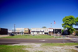
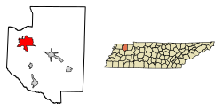
Martin is a city in Weakley County, Tennessee, United States. The population was 10,825 according to the 2020 census. The city is the home of the University of Tennessee at Martin.
Martin is named for Captain William Martin. [5] William Martin was born in Halifax County, Virginia in 1806, and moved to Weakley County, Tennessee with his wife Sarah in 1832. [5] Captain Martin prospered through tobacco farming and began working to establish a railroad connection in what would later become Martin in 1852. [5] It was not until after his death in 1859 that his sons, led primarily by George W. Martin, persuaded the Mississippi Central Railroad to locate a connection with the Nashville and Northwestern Railroad in what would become Martin, Tennessee in 1872. [5]
Martin is located at 36°20′31″N88°51′6″W / 36.34194°N 88.85167°W (36.341836, -88.851647). [6]
According to the United States Census Bureau, the city has a total area of 12.4 square miles (32 km2), of which 12.4 square miles (32 km2) is land and 0.04 square miles (0.10 km2) (0.32%) is water.
Climate data for Martin, Tennessee (University of Tennessee at Martin) 1991–2020 normals, extremes 1936–present | |||||||||||||
---|---|---|---|---|---|---|---|---|---|---|---|---|---|
Month | Jan | Feb | Mar | Apr | May | Jun | Jul | Aug | Sep | Oct | Nov | Dec | Year |
Record high °F (°C) | 77 (25) | 81 (27) | 86 (30) | 90 (32) | 98 (37) | 107 (42) | 105 (41) | 106 (41) | 105 (41) | 96 (36) | 87 (31) | 78 (26) | 107 (42) |
Mean daily maximum °F (°C) | 45.9 (7.7) | 50.8 (10.4) | 59.5 (15.3) | 70.2 (21.2) | 78.8 (26.0) | 86.5 (30.3) | 89.8 (32.1) | 89.5 (31.9) | 83.4 (28.6) | 72.4 (22.4) | 59.6 (15.3) | 49.3 (9.6) | 69.6 (20.9) |
Daily mean °F (°C) | 36.2 (2.3) | 40.5 (4.7) | 48.7 (9.3) | 58.7 (14.8) | 68.3 (20.2) | 76.3 (24.6) | 79.7 (26.5) | 78.4 (25.8) | 71.5 (21.9) | 59.7 (15.4) | 48.5 (9.2) | 39.8 (4.3) | 58.9 (14.9) |
Mean daily minimum °F (°C) | 26.5 (−3.1) | 30.3 (−0.9) | 37.8 (3.2) | 47.3 (8.5) | 57.8 (14.3) | 66.2 (19.0) | 69.7 (20.9) | 67.4 (19.7) | 59.6 (15.3) | 47.1 (8.4) | 37.4 (3.0) | 30.2 (−1.0) | 48.1 (8.9) |
Record low °F (°C) | −18 (−28) | −14 (−26) | −2 (−19) | 20 (−7) | 31 (−1) | 44 (7) | 48 (9) | 44 (7) | 33 (1) | 17 (−8) | 0 (−18) | −13 (−25) | −18 (−28) |
Average precipitation inches (mm) | 4.18 (106) | 4.74 (120) | 5.32 (135) | 5.29 (134) | 5.66 (144) | 4.30 (109) | 4.24 (108) | 3.45 (88) | 3.77 (96) | 3.98 (101) | 4.48 (114) | 5.31 (135) | 54.72 (1,390) |
Average snowfall inches (cm) | 1.2 (3.0) | 1.4 (3.6) | 0.4 (1.0) | 0.0 (0.0) | 0.0 (0.0) | 0.0 (0.0) | 0.0 (0.0) | 0.0 (0.0) | 0.0 (0.0) | 0.0 (0.0) | 0.1 (0.25) | 0.0 (0.0) | 3.1 (7.9) |
Average precipitation days (≥ 0.01 in) | 10.6 | 9.7 | 11.6 | 10.9 | 11.9 | 9.6 | 8.2 | 7.7 | 7.6 | 8.2 | 9.4 | 11.5 | 116.9 |
Average snowy days (≥ 0.1 in) | 0.9 | 0.9 | 0.1 | 0.0 | 0.0 | 0.0 | 0.0 | 0.0 | 0.0 | 0.0 | 0.1 | 0.3 | 2.3 |
Source: NOAA [7] [8] |
Census | Pop. | Note | %± |
---|---|---|---|
1900 | 1,730 | — | |
1910 | 2,228 | 28.8% | |
1920 | 2,837 | 27.3% | |
1930 | 3,300 | 16.3% | |
1940 | 3,587 | 8.7% | |
1950 | 4,082 | 13.8% | |
1960 | 4,750 | 16.4% | |
1970 | 7,781 | 63.8% | |
1980 | 8,898 | 14.4% | |
1990 | 8,600 | −3.3% | |
2000 | 10,515 | 22.3% | |
2010 | 11,473 | 9.1% | |
2020 | 10,825 | −5.6% | |
Sources: [9] [10] [3] |
Race | Num. | Perc. |
---|---|---|
White (non-Hispanic) | 7,892 | 72.91% |
Black or African American (non-Hispanic) | 1,910 | 17.64% |
Native American | 14 | 0.13% |
Asian | 131 | 1.21% |
Other/Mixed | 549 | 5.08% |
Hispanic or Latino | 329 | 3.04% |
As of the 2020 United States census, there were 10,825 people, 3,958 households, and 2,049 families residing in the city.
At the 2000 census there were 10,515 people, 3,773 households, and 2,029 families living in the city. The population density was 848.9 inhabitants per square mile (327.8/km2). There were 4,106 housing units at an average density of 331.5 per square mile (128.0/km2). The racial makeup of the city was 66.32% White, 25.62% African American, 0.08% Native American, 4.13% Asian, 0.97% from other races, and 0.89% from two or more races. Hispanic or Latino of any race were 3.82%. [4]
Of the 3,773 households 24.0% had children under the age of 18 living with them, 41.1% were married couples living together, 9.9% had a female householder with no husband present, and 46.2% were non-families. 34.1% of households were one person and 11.5% were one person aged 65 or older. The average household size was 2.20 and the average family size was 2.87.
The age distribution was 16.7% under the age of 18, 32.6% from 18 to 24, 21.4% from 25 to 44, 16.4% from 45 to 64, and 12.9% 65 or older. The median age was 26 years. For every 100 females, there were 89.9 males. For every 100 females age 18 and over, there were 86.0 males.
The median household income was $26,493 and the median family income was $38,648. Males had a median income of $29,836 versus $22,219 for females. The per capita income for the city was $15,184. About 15.8% of families and 27.1% of the population were below the poverty line, including 27.7% of those under age 18 and 15.7% of those age 65 or over.
The ZIP codes used in the Martin area are: 38237 and 38238, with the latter reserved for the University of Tennessee at Martin.
Weakley County is a county located in the northwest of the U.S. state of Tennessee. As of the 2020 census, the population was 32,902. Its county seat is Dresden. Its largest city is Martin, the home of the University of Tennessee at Martin. The county was established by the Tennessee General Assembly on October 21, 1823, and is named for U.S. Congressman Robert Weakley (1764–1845). Weakley County comprises the Martin, TN Micropolitan Statistical Area.
Henry County is a county located on the northwestern border of the U.S. state of Tennessee, and is considered part of West Tennessee. As of the 2020 census, the population was 32,199. Its county seat is Paris. The county is named for the Virginia orator and American Founding Father Patrick Henry.
Nondalton is a town on the west shore of Six Mile Lake in the Lake and Peninsula Borough, Alaska, United States. At the 2020 census, the population was 133, down from 164 in 2010.
Rossville is a city in Walker County, Georgia, United States. The population was 3,980 at the 2020 census. It is part of the Chattanooga, TN–GA Metropolitan Statistical Area.
Buffalo is a village in Mechanicsburg Township in Sangamon County, Illinois, United States. The population was 503 at the 2010 census. It is part of the Springfield, Illinois Metropolitan Statistical Area.
Warfield is a home rule-class city in Martin County, Kentucky, United States. The population was 264 at the 2020 census.
West Wyoming is a borough that is located in Luzerne County, Pennsylvania, United States. The borough is part of the Greater Pittston metro area.
Martin is a city and the county seat of Bennett County, South Dakota, United States. The population was 938 at the 2020 census.
Oak Hill is a city in Davidson County, Tennessee. The population was 4,529 at the 2010 census. The Tennessee Governor's Mansion is located in the city. Although the city is administered under the Metropolitan Government of Nashville and Davidson County, it retains its own municipal government.
Dyer is a city in Gibson County, Tennessee, United States. The population was 2,341 at the 2010 census. Dyer was originally known as Dyer Station, a name given by railroad workers in the early days of rail.
Crump is a city in Hardin County, Tennessee, United States. The population was 1,428 at the 2010 census, and 1,594 at the 2020 census.
La Vergne is a city in Rutherford County, Tennessee, United States. The population was 38,719 at the 2020 census. La Vergne lies within the Nashville Metropolitan Statistical Area.
Dover is a city in and the county seat of Stewart County, Tennessee, 67 miles (108 km) west-northwest of Nashville on the Cumberland River. Fort Donelson National Cemetery is in Dover. The population was 1,442 at the 2000 census and the 2010 census showed a population of 1,417.
Gilt Edge is a city in Tipton County, Tennessee. The population was 477 at the 2010 census and 456 in 2018, showing a decrease of 21.
Dresden is a town in and the county seat of Weakley County, Tennessee, United States. The population was 3,005 at the 2010 census.
Gleason is a town in Weakley County, Tennessee, United States. The population was 1,445 at the 2010 census. The city holds an annual Tater Town Parade and festival in the fall. The girls High School basketball team, the Lady Bulldogs, won the State Championship in 1992, 1999 and 2007.
Greenfield is a city in northwestern Weakley County, Tennessee, United States. The population was 2,182 at the 2010 census and 2,078 in 2018.
Sharon is a town in Weakley County, Tennessee, United States. The population was 988 at the 2000 census and 944 at the 2010 census.
Fairview is a city located in Williamson County, Tennessee. It is part of the Nashville metropolitan area. The population was 9,357 at the 2020 census,. In the communities just outside Fairview, there are an additional 4,100 people, for a total of over 13,457 people living within the Fairview area.
McKenzie is a city at the tripoint of Carroll, Henry, and Weakley counties in Tennessee, United States. The population was 5,310 at the 2010 census.