El Paso County is one of the 64 counties of the U.S. state of Colorado. The 2010 Census recorded its population of 622,263 for El Paso County. The Census Bureau's 2018 estimate indicates it is the second-most populous county in Colorado, after the City and County of Denver. The county seat is Colorado Springs, the second most populous city in Colorado. El Paso County is included in the Colorado Springs, Colorado, Metropolitan Statistical Area.

Etowah Indian Mounds (9BR1) are a 54-acre (220,000 m2) archaeological site in Bartow County, Georgia south of Cartersville, in the United States. Built and occupied in three phases, from 1000–1550 AD, the prehistoric site is located on the north shore of the Etowah River.

Hueco Tanks is an area of low mountains and historic site in El Paso County, Texas, in the United States. It is located in a high-altitude desert basin between the Franklin Mountains to the west and the Hueco Mountains to the east. Hueco is a Spanish word meaning hollows and refers to the many water-holding depressions in the boulders and rock faces throughout the region. Due to the unique concentration of historic artifacts, plants and wildlife, the site is under protection of Texas law; it is a crime to remove, alter, or destroy them.

Angel Mounds State Historic Site, an expression of the Mississippian culture, is an archaeological site managed by the Indiana State Museum and Historic Sites that includes more than 600 acres of land about 8 miles (13 km) southeast of present-day Evansville, in Vanderburgh and Warrick counties in Indiana. The large residential and agricultural community was constructed and inhabited from AD 1100 to AD 1450, and served as the political, cultural, and economic center of the Angel chiefdom. It extended within 120 miles (190 km) of the Ohio River valley to the Green River in present-day Kentucky. The town had as many as 1,000 inhabitants inside the walls at its peak, and included a complex of thirteen earthen mounds, hundreds of home sites, a palisade (stockade), and other structures.

Mounds State Park is a state park near Anderson, Madison County, Indiana featuring Native American heritage, and ten ceremonial mounds built by the prehistoric Adena culture indigenous peoples of eastern North America, and also used centuries later by Hopewell culture inhabitants. It is separate from the similarly named Mounds State Recreation Area.

Pictograph Cave is an area of three caves located 5 miles (8.0 km) south of Billings, Montana, United States, preserved and protected in the 23-acre (9.3 ha) Pictograph Cave State Park.

Peyton is an unincorporated town, a post office, and a census-designated place (CDP) located in and governed by El Paso County, Colorado, United States. The CDP is a part of the Colorado Springs, CO Metropolitan Statistical Area. The Peyton post office has the ZIP Code 80831. At the United States Census 2010, the population of the Peyton CDP was 250, while the population of the 80831 ZIP Code Tabulation Area was 21,993 including adjacent areas.

The Lindenmeier Site is a stratified multi-component archaeological site most famous for its Folsom component. The former Lindenmeier Ranch is in the Soapstone Prairie Natural Area, in northeastern Larimer County, Colorado, United States. The site contains the most extensive Folsom culture campsite yet found with a radiocarbon date of 10,600 to 10,720 B.P. Artifacts were also found from subsequent Archaic and Late pre-historic periods.

The Kincaid Mounds Historic Site c. 1050–1400 CE, is a Mississippian culture archaeological site located at the southern tip of present-day U.S. state of Illinois, along the Ohio River. Kincaid Mounds has been notable for both its significant role in native North American prehistory and for the central role the site has played in the development of modern archaeological techniques. The site had at least 11 substructure platform mounds, and 8 other monuments.

The Winterville Site is a major archaeological site in unincorporated Washington County, Mississippi, north of Greenville and along the river. It consists of major earthwork monuments, including more than twelve large platform mounds and cleared and filled plazas. It is the type site for the Winterville Phase of the Lower Yazoo Basin region of the Plaquemine Mississippian culture. Protected as a state park, it has been designated as a National Historic Landmark.
The Meadows Archeological District is a complex of four prehistoric archaeological sites in Warwick, Rhode Island. Discovered in 1980, the sites exhibit properties associated with the procurement and processing of stone tools. Three of the four sites include evidence of short-term habitation, and all four have shell middens. Occupation periods from the Archaic to the Woodland Period have been assigned to them. The district was added to the National Register of Historic Places in 1982, cited for its potential to yield new information about prehistoric Native patterns of living.

Poverty Point State Historical Site is a prehistoric earthwork constructed by the Poverty Point culture. The Poverty Point site is located in present-day northeastern Louisiana though evidence of the Poverty Point culture extends throughout much of the Southeastern Woodlands. The culture extended 100 miles (160 km) across the Mississippi Delta and south to the Gulf Coast. The Poverty Point site has been designated as a U.S. National Monument, a U.S. National Historic Landmark, and UNESCO World Heritage Site. Located in the Southern United States, the site is 15.5 miles (24.9 km) from the current flow of the Mississippi River, and is situated on the edge of Macon Ridge, near the village of Epps in West Carroll Parish, Louisiana.

The LoDaisKa Site is a prominent archaeological site in the U.S. state of Colorado, located within a rockshelter near Morrison. The rockshelter was first inhabited by people of the Archaic through the Middle Ceramic period, generally spanning 3000 BC to 1000 AD.

Franktown Cave is located 25 miles south of Denver, Colorado on the north edge of the Palmer Divide. It is the largest rock shelter documented on the Palmer Divide, which contains artifacts from many prehistoric cultures. Prehistoric hunter-gatherers occupied Franktown Cave intermittently for 8000 years beginning about 6400 B.C. The site held remarkable lithic and ceramic artifacts, but it is better known for its perishable artifacts, including animal hides, wood, fiber and corn. Material goods were produced for their comfort, task-simplification and religious celebration. There is evidence of the site being a campsite or dwelling as recent as AD 1725.

Roxborough State Park Archaeological District is located in Douglas County, Colorado. Roxborough State Park, 25 miles (40 km) south of Denver, Colorado, is a Colorado State Park day park. Archaeological artifacts reflect that there were prehistoric hunter-gatherers who lived or camped, made tools from stone quarries, and farmed in the Roxborough State Park area.

The Magic Mountain Site is an Archaic and Woodland village site in Jefferson County, Colorado dating from 4999 BC to 1000 AD. The site was added to the National Register of Historic Places in 1980.

The Trinchera Cave Archeological District (5LA9555) is an archaeological site in Las Animas County, Colorado with artifacts primarily dating from 1000 BC to AD 1749, although there were some Archaic period artifacts found. The site was added to the National Register of Historic Places in 2001 and is located on State Trust Lands.
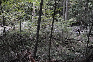
The Gentle Site (44-MD-112) is an archaeological site in Shenandoah National Park, in Madison County, Virginia, United States.

The Colorado Springs Pioneers Museum is located at 215 S. Tejon Street in Colorado Springs, Colorado. The granite building with a domed clock tower was the El Paso County Courthouse building from 1903 to 1973. The museum, which moved to this location in 1979, has fine arts, artifacts and archival collections that document the Pikes Peak region. The building is on the National Register of Historic Places, and was the 2nd property to be listed in El Paso County, after Pikes Peak.
21SL55 is a precontact Native American archaeological site in the Boundary Waters of northern Minnesota, United States. It was occupied by the Blackduck culture of the late Woodland period sometime between 700 and 1500 C.E. Located on a small island in what is now Voyageurs National Park, the site is known only by its Smithsonian trinomial. It contains well-preserved faunal remains, a possible ricing jig, and other subsurface features.