This article relies largely or entirely on a single source .(February 2023) |
Wauneta, Colorado | |
|---|---|
 Wauneta  Wauneta | |
| Coordinates: 40°17′34.96″N102°15′16.7″W / 40.2930444°N 102.254639°W [1] | |
| Country | United States |
| State | Colorado |
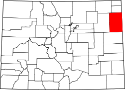
| County | Yuma |
| Elevation | 3,724 ft (1,135 m) |
| Time zone | UTC−7 (MST) |
| • Summer (DST) | UTC−6 (MDT) |
| Area code | 970 |
| FIPS code | 08-82970 [1] |
| GNIS ID | 182949 [1] |
Wauneta is an unincorporated community in Yuma County, Colorado, United States. [1]