Romeo, Colorado

Last updated

Town of Romeo, Colorado
Romeo, Colorado.JPG
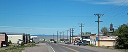
Main Street, looking west
Conejos County Colorado Incorporated and Unincorporated areas Romeo Highlighted 0865740.svg
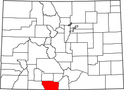
Location of Romeo in Conejos County, Colorado.
Coordinates: 37°10′19″N105°59′07″W / 37.17194°N 105.98528°W / 37.17194; -105.98528
CountryUnited States
State Colorado
County [1] Conejos County [2]
Incorporated (town) September 4, 1923 [3]
Government
  Type Statutory Town [1]
Area
[4]
  Total0.23 sq mi (0.60 km2)
  Land0.23 sq mi (0.60 km2)
  Water0.00 sq mi (0.00 km2)
Elevation
[2]
7,737 ft (2,358 m)
Population
 (2020) [5]
  Total302
  Density1,300/sq mi (500/km2)
Time zone UTC-7 (Mountain (MST))
  Summer (DST) UTC-6 (MDT)
ZIP code [6]
81148
Area code 719
FIPS code 08-65740
GNIS feature ID2412574 [2]

Romeo is a Statutory Town in Conejos County, Colorado, United States. The population was 302 at the 2020 census. [5] A post office called Romeo was established in 1901. [7] The community derives its name from the surname Romero. [8]

Contents

Geography

Romeo is located in east-central Conejos County in the San Luis Valley region. U.S. Route 285 runs along the western border of the town, leading north 21 miles (34 km) to Alamosa and south 12 miles (19 km) to the New Mexico border and beyond. Colorado State Highway 142 is the town's Main Street, with its western terminus at U.S. 285 and leading east 3 miles (5 km) to Manassa and 32 miles (51 km) to San Luis.

According to the United States Census Bureau, the town has a total area of 0.2 square miles (0.52 km2), all of it land.

Demographics

Historical population
CensusPop.Note
1930 188
1940 392108.5%
1950 4043.1%
1960 339−16.1%
1970 3523.8%
1980 308−12.5%
1990 34110.7%
2000 37510.0%
2010 4047.7%
2020 302−25.2%

See also

Related Research Articles

<span class="mw-page-title-main">Conejos County, Colorado</span> County in Colorado, United States

Conejos County is a county located in the U.S. state of Colorado. As of the 2020 census, the population was 7,461. The county seat is the unincorporated community of Conejos.

<span class="mw-page-title-main">Hooper, Colorado</span> Town in Colorado, United States

The Town of Hooper is a Statutory Town located in the San Luis Valley in Alamosa County, Colorado, United States. The population was 81 at the 2020 census.

<span class="mw-page-title-main">Pritchett, Colorado</span> Town in Colorado, United States

Pritchett is a Statutory Town in Baca County, Colorado, United States. The population was 112 at the 2020 census.

<span class="mw-page-title-main">Antonito, Colorado</span> Town in Colorado, United States

Antonito is a Statutory Town located in Conejos County, Colorado, United States. The town population was 647 at the 2020 United States Census.

<span class="mw-page-title-main">La Jara, Colorado</span> Town in Colorado, United States

La Jara is a statutory town in Conejos County, Colorado, United States. The population was 730 at the 2020 United States Census.

<span class="mw-page-title-main">Manassa, Colorado</span> Town in Colorado, United States

Founded in 1851, the Town of Manassa is a Statutory Town and is the most populous municipality in Conejos County, Colorado, United States. The town's population was 947 at the 2020 United States Census.

<span class="mw-page-title-main">Sanford, Colorado</span> Town in Conejos County, Colorado, United States

Sanford is a statutory town in Conejos County, Colorado, United States. The population was 879 at the 2020 census.

<span class="mw-page-title-main">Blanca, Colorado</span> Town in Colorado, United States

Blanca is a Statutory Town located in Costilla County, Colorado, United States. The town population was 322 at the 2020 census. Blanca is located in the enormous San Luis Valley.

<span class="mw-page-title-main">San Luis, Colorado</span> Town in Colorado, United States

San Luis is a statutory town that is the county seat and the most populous town of Costilla County, Colorado, United States. Formerly known as San Luis de la Culebra, it is the oldest continuously occupied town in Colorado. The population was 598 at the 2020 census.

<span class="mw-page-title-main">Ordway, Colorado</span> Town in and county seat of Crowley County, Colorado, United States

Ordway is a Statutory Town in and the county seat of Crowley County, Colorado, United States, that is also the most populous community in the county. The population was 1,066 at the 2020 census.

<span class="mw-page-title-main">Rico, Colorado</span> Town in Colorado, United States

Rico is a town in Dolores County, Colorado, United States. It was settled in 1879 as a silver mining center in the Pioneer Mining District; today it functions as a historic and tourism site. The population was 288 at the 2020 census. Its current form of government is that of a home rule municipality.

<span class="mw-page-title-main">Edwards, Colorado</span> Census Designated Place in Colorado, United States

Edwards is an unincorporated town, a post office, and a census-designated place (CDP) located in and governed by Eagle County, Colorado, United States. Edwards is the principal town of the Edwards, CO Micropolitan Statistical Area. The Edwards post office has the ZIP Code 81632. At the United States Census 2020, the population of the Edwards CDP was 11,246. The Edwards Metropolitan District provides services.

<span class="mw-page-title-main">Sheridan Lake, Colorado</span> Town in Colorado, United States

Sheridan Lake is a Statutory Town located in Kiowa County, Colorado, United States. The population was 55 at the 2020 census.

<span class="mw-page-title-main">Center, Colorado</span> Town in Saguache and Rio Grande counties in Colorado, United States

The Town of Center is a Statutory Town located in Saguache and Rio Grande counties in Colorado, United States. The town's population was 1,929 at the 2020 United States Census with 1,885 residing in Saguache County and 44 residing in Rio Grande County.

<span class="mw-page-title-main">Monte Vista, Colorado</span> City in Rio Grande County, Colorado, United States

The City of Monte Vista is the home rule municipality that is the most populous municipality in Rio Grande County, Colorado, United States. The city population was 4,247 at the 2020 Census.

<span class="mw-page-title-main">Moffat, Colorado</span> Town in Saguache County, Colorado, United States

The Town of Moffat is a statutory town in Saguache County, Colorado, United States. The town population was 108 at the 2020 United States Census.

<span class="mw-page-title-main">Conejos, Colorado</span> Census Designated Place in Colorado, United States

Conejos is an unincorporated town, a post office, a census-designated place (CDP), and the county seat of Conejos County, Colorado, United States. The Conejos post office has the ZIP Code 81129. At the United States Census 2020, the population of the Conejos CDP was 46. Conejos is the only unincorporated county seat in the State of Colorado.

<span class="mw-page-title-main">Howard, Colorado</span> Census-designated place in Fremont County, Colorado, United States

Howard is a census-designated place (CDP) and post office in and governed by Fremont County, Colorado, United States. The CDP is a part of the Cañon City, CO Micropolitan Statistical Area. The Howard post office has the ZIP Code 81233. At the United States Census 2020, the population of the Howard CDP was 852.

<span class="mw-page-title-main">McCoy, Colorado</span> Census Designated Place in Colorado, United States

McCoy is an unincorporated town, a census-designated place (CDP), and a post office located in and governed by Eagle County, Colorado, United States. The CDP is a part of the Edwards, CO Micropolitan Statistical Area. The McCoy post office has the ZIP Code 80463. At the United States Census 2020, the population of the McCoy CDP was 30.

<span class="mw-page-title-main">San Acacio, Colorado</span> Census Designated Place in Colorado, United States

San Acacio is an unincorporated community and a census-designated place (CDP) located in and governed by Costilla County, Colorado, United States. The population of the San Acacio CDP was 56 at the 2020 United States census. The Sanford post office serves San Acacio postal addresses.

References

  1. 1 2 "Active Colorado Municipalities". State of Colorado, Department of Local Affairs. Archived from the original on December 12, 2009. Retrieved September 1, 2007.
  2. 1 2 3 U.S. Geological Survey Geographic Names Information System: Romeo, Colorado
  3. "Colorado Municipal Incorporations". State of Colorado, Department of Personnel & Administration, Colorado State Archives. December 1, 2004. Retrieved September 2, 2007.
  4. "2019 U.S. Gazetteer Files". United States Census Bureau. Retrieved July 1, 2020.
  5. 1 2 United States Census Bureau. "Romeo town, Colorado" . Retrieved April 2, 2023.
  6. "ZIP Code Lookup" (JavaScript/HTML). United States Postal Service . Retrieved December 26, 2007.
  7. "Post offices". Jim Forte Postal History. Retrieved July 9, 2016.
  8. Dawson, John Frank. Place names in Colorado: why 700 communities were so named, 150 of Spanish or Indian origin. Denver, CO: The J. Frank Dawson Publishing Co. p. 44.