Crowley, Colorado

Last updated

Crowley, Colorado
Town of Crowley [1]
Crowley County Heritage Center from SE 1.JPG
The 
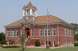
Crowley County Heritage Center, formerly the Crowley School, is listed in the National Register of Historic Places. [3]
Crowley County Colorado Incorporated and Unincorporated areas Crowley Highlighted 0818750.svg
Location of the Town of Crowley in the Crowley County, Colorado.
Usa edcp location map.svg
Red pog.svg
Crowley
Location of the Town of Crowley in the United States.
Coordinates: 38°11′37″N103°51′35″W / 38.193506°N 103.859744°W / 38.193506; -103.859744 [4]
Country Flag of the United States.svg  United States
State Flag of Colorado.svg  Colorado
County Crowley County [1]
Incorporated October 10, 1921 [5]
Government
  Type Statutory Town [1]
Area
[6]
  Total0.225 sq mi (0.584 km2)
  Land0.225 sq mi (0.584 km2)
  Water0.000 sq mi (0.000 km2)
Elevation
[7]
4,354 ft (1,327 m)
Population
 (2020) [6]
  Total166
  Density740/sq mi (280/km2)
Time zone UTC−07:00 (MST)
  Summer (DST) UTC−06:00 (MDT)
ZIP codes [8]
81033-81034
Area code 719
FIPS code 08-18750
GNIS feature ID 0195382

The Town of Crowley is a Statutory Town in Crowley County, Colorado, United States. [1] The town population was 166 at the 2020 United States Census. [6]

Contents

Geography

Crowley as photographed by the Soil Conservation Service in 1936. AG 281-29 - DPLA - 3b750f4d4bb4e98eccfe9b8b31d93407.jpg
Crowley as photographed by the Soil Conservation Service in 1936.

Crowley is located in southern Crowley County at 38°11′37″N103°51′28″W / 38.19361°N 103.85778°W / 38.19361; -103.85778 (38.193614, -103.857802). [9] Colorado State Highway 96 leads east 6 miles (10 km) to Ordway, the county seat, and west 43 miles (69 km) to Pueblo. Highway 207 leads south 6 miles (10 km) to Manzanola and U.S. Route 50.

At the 2020 United States Census, the town had a total area of 144 acres (0.584 km2), all of it land. [6]

Demographics

Historical population
CensusPop.Note
1920 224
1930 32344.2%
1940 318−1.5%
1950 37919.2%
1960 265−30.1%
1970 216−18.5%
1980 192−11.1%
1990 22517.2%
2000 187−16.9%
2010 176−5.9%
2020 166−5.7%
U.S. Decennial Census

Notable people

Jonathan Almanzar (founder of Chick'nCone) [10]

See also

Related Research Articles

<span class="mw-page-title-main">Otero County, Colorado</span> County in Colorado, United States

Otero County is a county located in the U.S. state of Colorado. As of the 2020 census, the population was 18,690. The county seat is La Junta. The county was named for Miguel Antonio Otero, one of the founders of the town of La Junta and a member of a prominent Hispanic family.

<span class="mw-page-title-main">Crowley County, Colorado</span> County in Colorado, United States

Crowley County is a county in Colorado. As of the 2020 census, the population was 5,922. The county seat is Ordway.

<span class="mw-page-title-main">Enola, Arkansas</span> Town in Arkansas, United States

Enola is a town in Faulkner County, Arkansas, United States. It is part of the Central Arkansas region. The population was 318 at the 2020 census.

<span class="mw-page-title-main">Two Buttes, Colorado</span> Town in Colorado, United States

Two Buttes is a Statutory Town located in Baca County, Colorado, United States. The population was 34 at the 2020 census.

<span class="mw-page-title-main">Jamestown, Colorado</span> Town in Colorado, United States

The historic Town of Jamestown is a Statutory Town in Boulder County, Colorado, United States. The population was 256 at the 2020 United States Census, down from 274 in 2010. It was named for James Smith, an early discoverer of gold. Jamestown was hit hard by the September 2013 Colorado floods when the town was isolated due to road damage from the rains and the flooding of James Creek. Under a mandatory evacuation order, most residents were airlifted to safety under the direction of the Colorado National Guard to nearby Boulder.

<span class="mw-page-title-main">Romeo, Colorado</span> Town in Colorado, United States

Romeo is a Statutory Town in Conejos County, Colorado, United States. The population was 302 at the 2020 census. A post office called Romeo was established in 1901. The community derives its name from the surname Romero.

<span class="mw-page-title-main">Olney Springs, Colorado</span> Town in Crowley County, Colorado, United States

Olney Springs is a Statutory Town in Crowley County, Colorado, United States. The population was 315 at the 2020 census.

<span class="mw-page-title-main">Ordway, Colorado</span> Town in and county seat of Crowley County, Colorado, United States

Ordway is a Statutory Town in and the county seat of Crowley County, Colorado, United States, that is also the most populous community in the county. The population was 1,066 at the 2020 census.

<span class="mw-page-title-main">Sugar City, Colorado</span> Town in Colorado, United States

Sugar City is a Statutory Town in Crowley County, Colorado, United States. The population was 259 at the 2020 census.

<span class="mw-page-title-main">Hotchkiss, Colorado</span> Town in Colorado, United States

Hotchkiss is a statutory town in Delta County, Colorado, United States. The population was 875 at the 2020 census.

<span class="mw-page-title-main">Larkspur, Colorado</span> Town in Colorado, United States

Larkspur is a home rule municipality in Douglas County, Colorado, United States. The town population was 206 at the 2020 census. Each year, on weekends in June, July and August, the Colorado Renaissance Festival is held in the hills just west of the town. The town is served by Larkspur Elementary School, a K-6 school in the Douglas County school district. The according to William Bright the town was named for the plains larkspur.

<span class="mw-page-title-main">Minturn, Colorado</span> Town in Colorado, United States

Minturn is a home rule municipality in Eagle County, Colorado, United States. The town population was 1,033 at the 2020 United States Census.

<span class="mw-page-title-main">Kiowa, Colorado</span> Town in Colorado, United States

Kiowa is a home rule municipality town and the county seat of Elbert County, Colorado, United States. The town population was 725 at the 2020 United States Census.

<span class="mw-page-title-main">Haswell, Colorado</span> Town in Colorado, United States

Haswell is a Statutory Town located in Kiowa County, Colorado, United States. The town population was 71 at the 2020 United States Census.

<span class="mw-page-title-main">Sheridan Lake, Colorado</span> Town in Colorado, United States

Sheridan Lake is a Statutory Town located in Kiowa County, Colorado, United States. The population was 55 at the 2020 census.

<span class="mw-page-title-main">Merino, Colorado</span> Town in Colorado, United States

The Town of Merino is a Statutory Town in Logan County, Colorado, United States. The town population was 281 at the 2020 United States Census.

<span class="mw-page-title-main">Dinosaur, Colorado</span> Town in Colorado, United States

Dinosaur is a statutory town in Moffat County, Colorado, United States. As of the 2020 census, the population was 243, down from 339 at the 2010 census.

<span class="mw-page-title-main">Log Lane Village, Colorado</span> Town in Colorado, United States

Log Lane Village is a statutory town in Morgan County, Colorado, United States. The population was 913 at the 2020 census.

<span class="mw-page-title-main">Akron, Colorado</span> Town in Colorado, United States

Akron is the Statutory Town that is the county seat and the most populous municipality of Washington County, Colorado, United States. The town population was 1,757 at the 2020 United States Census.

<span class="mw-page-title-main">Wray, Colorado</span> City in Colorado, United States

Wray is the home rule municipality that is the county seat of Yuma County, Colorado, United States. Located in the Colorado Plains, the city is 170 miles east of Denver, 9 miles west of the Nebraska state line, and 25 miles northwest of the Kansas state line. The population was 2,358 at the 2020 United States census.

References

  1. 1 2 3 4 5 "Active Colorado Municipalities". Colorado Department of Local Affairs . Retrieved October 15, 2021.
  2. "Crowley County Heritage Center". Archived 2013-09-02 at the Wayback Machine Retrieved 2012-08-27.
  3. "Crowley County Heritage Center". Archived 2013-09-02 at the Wayback Machine Retrieved 2012-08-27.
  4. "2014 U.S. Gazetteer Files: Places". United States Census Bureau. July 1, 2014. Retrieved January 5, 2015.
  5. "Colorado Municipal Incorporations". State of Colorado, Department of Personnel & Administration, Colorado State Archives. December 1, 2004. Retrieved September 2, 2007.
  6. 1 2 3 4 "Decennial Census P.L. 94-171 Redistricting Data". United States Census Bureau, United States Department of Commerce. August 12, 2021. Retrieved September 4, 2021.
  7. "US Board on Geographic Names". United States Geological Survey. October 25, 2007. Retrieved January 31, 2008.
  8. "ZIP Code Lookup". United States Postal Service. Archived from the original (JavaScript/HTML) on November 4, 2010. Retrieved September 6, 2007.
  9. "US Gazetteer files: 2010, 2000, and 1990". United States Census Bureau. February 12, 2011. Retrieved April 23, 2011.
  10. "Founders". Chick'nCone. Retrieved June 3, 2018.[ permanent dead link ]