
The San Luis Valley is a region in south-central Colorado with a small portion overlapping into New Mexico. The valley is approximately 122 miles (196 km) long and 74 miles (119 km) wide, extending from the Continental Divide on the northwest rim into New Mexico on the south. It contains 6 counties and portions of 3 others. It is an extensive high-elevation depositional basin of approximately 8,000 square miles (21,000 km2) with an average elevation of 7,664 feet (2,336 m) above sea level. The valley is a section of the Rio Grande Rift and is drained to the south by the Rio Grande, which rises in the San Juan Mountains to the west of the valley and flows south into New Mexico. The San Luis Valley has a cold desert climate but has substantial water resources from the Rio Grande and groundwater.

Rio Blanco County is a county located in the U.S. state of Colorado. As of the 2020 census, the population was 6,529. The county seat is Meeker. The name of the county is the Spanish name for the White River which runs through it.

Rifle is a home rule municipality in and the most populous community of Garfield County, Colorado, United States. The population was 10,437 at the 2020 census. Rifle is a regional center of the cattle ranching industry located along Interstate 70 and the Colorado River just east of the Roan Plateau, which dominates the western skyline of the town. The town was founded in 1882 by Abram Maxfield, and was incorporated in 1905 along Rifle Creek, near its mouth on the Colorado. The community takes its name from the creek.
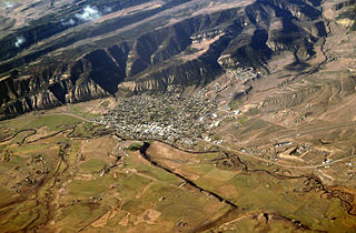
Meeker is the Statutory Town in and the county seat of Rio Blanco County, Colorado, United States, that is the most populous municipality in the county. The town population was 2,374 at the 2020 United States Census.

Rangely is a Statutory Town in Rio Blanco County, Colorado, United States. The population was 2,299 at the 2020 census. Rangely is the home of Colorado Northwestern Community College.

Great Sand Dunes National Park and Preserve is an American national park that conserves an area of large sand dunes up to 750 feet (230 m) tall on the eastern edge of the San Luis Valley, and an adjacent national preserve in the Sangre de Cristo Range, in south-central Colorado, United States. The park was originally designated Great Sand Dunes National Monument on March 17, 1932, by President Herbert Hoover. The original boundaries protected an area of 35,528 acres. A boundary change and redesignation as a national park and preserve was authorized on November 22, 2000, and then established on September 24, 2004. The park encompasses 107,342 acres while the preserve protects an additional 41,686 acres for a total of 149,028 acres. The recreational visitor total was 527,546 in 2019.

White River National Forest is a National Forest in northwest Colorado. It is named after the White River that passes through its northern section. It is the most visited National Forest in the United States, primarily from users of the twelve ski areas within its boundaries.

Meeker Massacre, or Meeker Incident, White River War, Ute War, or the Ute Campaign), took place on September 29, 1879 in Colorado. Members of a band of Ute Indians attacked the Indian agency on their reservation, killing the Indian agent Nathan Meeker and his 10 male employees and taking five women and children as hostages. Meeker had been attempting to convert the Utes to Christianity, to make them farmers, and to prevent them from following their nomadic culture. On the same day as the massacre, United States Army forces were en route to the Agency from Fort Steele in Wyoming due to threats against Meeker. The Utes attacked U.S. troops led by Major Thomas T. Thornburgh at Milk Creek, 18 mi (29 km) north of present day Meeker, Colorado. They killed the major and 13 troops. Relief troops were called in and the Utes dispersed.

State Highway 13 (SH 13) in the U.S. state of Colorado is a north–south mountain route that travels from Rifle to the Wyoming border near Baggs, Wyoming, through the Rocky Mountains.

With a total area of 121,590 square miles (314,900 km2), New Mexico is the fifth-largest state, after Alaska, Texas, California, and Montana. Its eastern border lies along 103°W longitude with the state of Oklahoma, and 2.2 miles west of 103°W longitude with Texas. On the southern border, Texas makes up the eastern two-thirds, while the Mexican states of Chihuahua and Sonora make up the western third, with Chihuahua making up about 90% of that. The western border with Arizona runs along the 109° 03'W longitude. The southwestern corner of the state is known as the Bootheel. The 37°N parallel forms the northern boundary with Colorado. The states of New Mexico, Colorado, Arizona, and Utah come together at the Four Corners in New Mexico's northwestern corner. Its surface water area is about 292 square miles (760 km2).

Vega State Park is a 1,823-acre (738 ha) Colorado state park in Mesa County, Colorado in the United States. Vega Reservoir is a fishing destination and is located at an elevation of 7,696 feet (2,346 m). Year-round recreational activities at Vega State Park include boating, hiking, snowmobiling and camping. The park was established in 1967 in cooperation with the Bureau of Reclamation which was responsible for the construction of Vega Dam and Vega Reservoir.

The Grand Hogback is a 70-mile long, curving, spine-like ridge in Western Colorado that extends from near McClure Pass in Pitkin County through Garfield County and then to near Meeker in Rio Blanco County. The hogback is significant because it marks part of the boundary between the Colorado Plateau to the west and the Southern Rocky Mountains to the east.
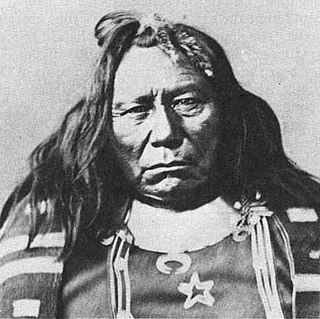
Colorow was a Ute chief of the Ute Mountain Utes, skilled horseman, and warrior. He was involved in treaty negotiations with the U.S. government. In 1879, he fought during the Meeker Massacre. Eight years later, his family members were attacked during Colorow's War. He was placed in the Jefferson County Hall of Fame in recognition of for the contributions that "he made to our county and, indeed, our state and nation."

White River City is an Unincorporated community along the White River and Piceance Creek in Rio Blanco County, Colorado, United States.

Rio Blanco Lake State Wildlife Area, including the Rio Blanco Lake reservoir, is recreational area operated by the Colorado Parks and Wildlife. It is located in White River City in Rio Blanco County, Colorado. Located on 383 acres, recreational activities include fishing and camping. Facilities include a boat ramp and restrooms.
Russell Lloyd George is an American politician and lawyer from the state of Colorado.

Lake Avery is a reservoir in Rio Blanco County, Colorado about 20 miles southeast of the town of Meeker. It also lies west of the unincorporated community of Buford. The reservoir is owned by Colorado Parks and Wildlife, and its dam impounds Big Beaver Creek, a tributary of the White River. Lake Avery is also called Big Beaver Reservoir, however it is unclear whether the name has changed or whether the reservoir just has two names.
