
Rio Blanco County is a county located in the U.S. state of Colorado. As of the 2020 census, the population was 6,529. The county seat is Meeker. The name of the county is the Spanish name for the White River which runs through it.

Jefferson County is a county located in the U.S. state of Colorado. As of the 2020 census, the population was 582,910, making it the fourth-most populous county in Colorado. The county seat is Golden, and the most populous city is Lakewood.

The City of Sheridan is a home rule municipality located in Arapahoe County, Colorado, United States. Sheridan is a part of the Denver–Aurora–Lakewood, CO Metropolitan Statistical Area. The population was 6,105 at the 2020 census.

Allenspark is an unincorporated town, a post office, and a census-designated place (CDP) located in and governed by Boulder County, Colorado, United States. The CDP is a part of the Boulder, CO Metropolitan Statistical Area. The Allenspark post office has the ZIP code 80510. At the United States Census 2020, the population of the Allenspark CDP was 568.

Rifle is a home rule municipality in, and the most populous community of, Garfield County, Colorado, United States. The population was 10,437 at the 2020 census. Rifle is a regional center of the cattle ranching industry located along Interstate 70 and the Colorado River just east of the Roan Plateau, which dominates the western skyline of the town. The town was founded in 1882 by Abram Maxfield, and was incorporated in 1905 along Rifle Creek, near its mouth on the Colorado. The community takes its name from the creek.
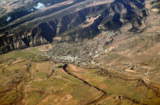
Meeker is a statutory town in and the county seat of Rio Blanco County, Colorado, United States, that is the most populous municipality in the county. The town population was 2,374 at the 2020 United States Census.

Rangely is a statutory town in Rio Blanco County, Colorado, United States. The population was 2,299 at the 2020 census. Rangely is the home of Colorado Northwestern Community College.

White River is a river, approximately 195 miles (314 km) long, in the U.S. states of Colorado and Utah and is a tributary of the Green River.
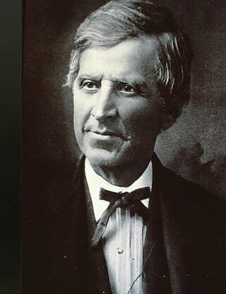
Nathan Cook Meeker was a 19th-century American journalist, homesteader, entrepreneur, and Indian agent for the federal government. He is noted for his founding in 1870 of the Union Colony, a cooperative agricultural colony in present-day Greeley, Colorado.

Meeker Massacre, or Meeker Incident, White River War, Ute War, or the Ute Campaign), took place on September 29, 1879 in Colorado. Members of a band of Ute Indians attacked the Indian agency on their reservation, killing the Indian agent Nathan Meeker and his 10 male employees and taking five women and children as hostages. Meeker had been attempting to convert the Utes to Christianity, to make them farmers, and to prevent them from following their nomadic culture. On the same day as the massacre, United States Army forces were en route to the Agency from Fort Steele in Wyoming due to threats against Meeker. The Utes attacked U.S. troops led by Major Thomas T. Thornburgh at Milk Creek, 18 miles (29 km) north of present day Meeker, Colorado. They killed the major and 13 troops. Relief troops were called in and the Utes dispersed.

State Highway 13 (SH 13) in the U.S. state of Colorado is a north–south mountain route that travels from Rifle to the Wyoming border near Baggs, Wyoming, through the Rocky Mountains.

The Uinta Basin is a physiographic section of the larger Colorado Plateaus province, which in turn is part of the larger Intermontane Plateaus physiographic division. It is also a geologic structural basin in eastern Utah, east of the Wasatch Mountains and south of the Uinta Mountains. The Uinta Basin is fed by creeks and rivers flowing south from the Uinta Mountains. Many of the principal rivers flow into the Duchesne River which feeds the Green River—a tributary of the Colorado River. The Uinta Mountains form the northern border of the Uinta Basin. They contain the highest point in Utah, Kings Peak, with a summit 13,528 feet above sea level. The climate of the Uinta Basin is semi-arid, with occasionally severe winter cold.

The Austin–Round Rock–San Marcos metropolitan statistical area, or Greater Austin, is a five-county metropolitan area in the U.S. state of Texas, as defined by the Office of Management and Budget. The metropolitan area is situated in Central Texas on the western edge of the American South and on the eastern edge of the American Southwest, and borders Greater San Antonio to the south.

The Piceance Basin is a geologic structural basin in northwestern Colorado, in the United States. It includes geologic formations from Cambrian to Holocene in age, but the thickest section is made up of rocks from the Cretaceous Period. The basin contains reserves of coal, natural gas, and oil shale. The name likely derives from the Shoshoni word /piasonittsi/ meaning “tall grass”.
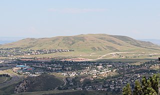
Lakewood is the home rule municipality that is the most populous municipality in Jefferson County, Colorado, United States. The city population was 155,984 at the 2020 U.S. Census, making Lakewood the fifth most populous city in Colorado and the 167th most populous city in the United States. Lakewood is a suburb of Denver and is a principal city of the Denver–Aurora–Lakewood, CO Metropolitan Statistical Area and a major city of the Front Range Urban Corridor.

Chipeta or White Singing Bird was a Native American leader, and the second wife of Chief Ouray of the Uncompahgre Ute tribe. Born a Kiowa Apache, she was raised by the Utes in what is now Conejos, Colorado. An advisor and confidant of her husband, Chipeta continued as a leader of her people after his death in 1880.

Piceance Creek is a 57.9-mile-long (93.2 km) tributary of the White River in Garfield and Rio Blanco counties in Colorado, United States. The name likely derives from the Shoshoni word /piasonittsi/ meaning “tall grass”.

Travis County has had two locations named Montopolis. The first was during the Republic of Texas period north of the Colorado River. The second is today's Montopolis neighborhood in Austin, Texas south of the river. Located southeast of the city's urban core, today's neighborhood is in ZIP code 78741. Montopolis is bounded by Lake Lady Bird on the north, by Grove Street and the Pleasant Valley neighborhood on the west, to the south by Texas State Highway 71, and by U.S. Route 183 on the east. The southeast corner abuts Austin-Bergstrom International Airport. Montopolis is in City Council District 3.


