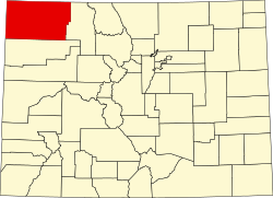
Hamilton, Colorado

Last updated

Hamilton, Colorado
USA Colorado location map.svg
Red pog.svg
Hamilton, Colorado
Usa edcp location map.svg
Red pog.svg
Hamilton, Colorado
Coordinates: 40°22′02″N107°36′47″W / 40.36722°N 107.61306°W / 40.36722; -107.61306
Country Flag of the United States (23px).png  United States
State Flag of Colorado.svg  Colorado
Counties Moffat [1]
Elevation
[1]
6,244 ft (1,903 m)
Time zone UTC-7 (MST)
  Summer (DST) UTC-6 (MDT)
ZIP code [2]
81638
Area code 970
GNIS feature ID171491 [1]

Hamilton is an unincorporated community with a U.S. Post Office in Moffat County, Colorado, United States. The Hamilton Post Office has the ZIP Code 81638. [2]

Climate

Craig 4SW is a weather station near Hamilton. [3] Craig 4SW has a humid continental climate (Köppen Dfb).

Climate data for Craig 4SW, Colorado, 1991–2020 normals, 1977-2020 records: 6496ft (1980m)
MonthJanFebMarAprMayJunJulAugSepOctNovDecYear
Record high °F (°C)57
(14)
63
(17)
76
(24)
80
(27)
88
(31)
98
(37)
99
(37)
96
(36)
97
(36)
85
(29)
73
(23)
60
(16)
99
(37)
Mean maximum °F (°C)44.7
(7.1)
50.2
(10.1)
64.7
(18.2)
73.2
(22.9)
80.8
(27.1)
89.2
(31.8)
93.4
(34.1)
91.5
(33.1)
86.6
(30.3)
77.4
(25.2)
63.8
(17.7)
49.3
(9.6)
94.1
(34.5)
Mean daily maximum °F (°C)30.3
(−0.9)
35.3
(1.8)
46.9
(8.3)
56.0
(13.3)
65.7
(18.7)
77.8
(25.4)
85.2
(29.6)
83.2
(28.4)
74.6
(23.7)
60.6
(15.9)
44.8
(7.1)
31.9
(−0.1)
57.7
(14.3)
Daily mean °F (°C)18.6
(−7.4)
23.0
(−5.0)
33.4
(0.8)
41.5
(5.3)
50.6
(10.3)
60.3
(15.7)
67.4
(19.7)
65.7
(18.7)
57.0
(13.9)
44.4
(6.9)
31.6
(−0.2)
20.3
(−6.5)
42.8
(6.0)
Mean daily minimum °F (°C)7.0
(−13.9)
10.8
(−11.8)
19.9
(−6.7)
27.0
(−2.8)
35.5
(1.9)
42.8
(6.0)
49.6
(9.8)
48.2
(9.0)
39.3
(4.1)
28.3
(−2.1)
18.4
(−7.6)
8.8
(−12.9)
28.0
(−2.3)
Mean minimum °F (°C)−12.0
(−24.4)
−7.1
(−21.7)
5.0
(−15.0)
16.0
(−8.9)
25.6
(−3.6)
34.5
(1.4)
42.9
(6.1)
41.3
(5.2)
28.8
(−1.8)
14.0
(−10.0)
0.2
(−17.7)
−10.4
(−23.6)
−17.0
(−27.2)
Record low °F (°C)−36
(−38)
−41
(−41)
−13
(−25)
−1
(−18)
18
(−8)
23
(−5)
34
(1)
31
(−1)
16
(−9)
−10
(−23)
−16
(−27)
−31
(−35)
−41
(−41)
Average precipitation inches (mm)1.20
(30)
1.10
(28)
1.28
(33)
1.85
(47)
1.88
(48)
1.08
(27)
1.19
(30)
1.28
(33)
1.79
(45)
1.83
(46)
1.42
(36)
1.45
(37)
17.35
(440)
Average snowfall inches (cm)14.5
(37)
11.0
(28)
8.7
(22)
5.1
(13)
1.2
(3.0)
trace0.0
(0.0)
0.0
(0.0)
trace3.2
(8.1)
9.0
(23)
14.9
(38)
67.6
(172.1)
Average extreme snow depth inches (cm)11.2
(28)
9.8
(25)
6.6
(17)
3.1
(7.9)
1.1
(2.8)
0.0
(0.0)
0.0
(0.0)
0.0
(0.0)
0.4
(1.0)
2.7
(6.9)
5.0
(13)
9.3
(24)
14.0
(36)
Average precipitation days (≥ 0.01 in)76677556666673
Average snowy days (≥ 0.1 in)86531000014634
Source 1: NOAA [4]
Source 2: XMACIS2 (records, monthly max/mins, snow & precip/snow days) [5]

Related Research Articles

<span class="mw-page-title-main">ZIP Code</span> Numeric postal code used in the United States and its territories

A ZIP Code is a system of postal codes used by the United States Postal Service (USPS). The term ZIP was chosen to suggest that the mail travels more efficiently and quickly when senders use the code in the postal address.

<span class="mw-page-title-main">Rollinsville, Colorado</span> Census-designated place in Gilpin County, Colorado, United States

Rollinsville is a census-designated place (CDP) and post office in and governed by Gilpin County, Colorado, United States. The CDP is a part of the Denver–Aurora–Lakewood, CO Metropolitan Statistical Area. The Rollinsville post office has the ZIP Code 80474. At the United States Census 2020, the population of the Rollinsville CDP was 194.

<span class="mw-page-title-main">Grant, Colorado</span> Unincorporated community in Park County, Colorado, United States

Grant is an unincorporated community and a U.S. Post Office in Park County, Colorado, United States.

<span class="mw-page-title-main">Jefferson, Colorado</span> Unincorporated community in Park County, Colorado, United States

Jefferson is an unincorporated community in Park County, Colorado, United States.

<span class="mw-page-title-main">Como, Colorado</span> Unincorporated community in Park County, Colorado, United States

Como is an unincorporated community in Park County in the Rocky Mountains of central Colorado, United States. According to the 2010 census, the population of zip code 80432 is 439, including surrounding subdivisions in a 15 mile radius. Metropolitan Como proper usually has a population of 12 to 15 residents, within the Como plat.

<span class="mw-page-title-main">Cimarron, Colorado</span> Unincorporated community in State of Colorado, United States

Cimarron is an unincorporated rural hamlet in Montrose County, Colorado, United States. It is located on the northern side of U.S. Highway 50, 19 miles from the town of Montrose to its west, and 42 miles from Gunnison, Colorado to its east. There is a store with fuel pumps and a post office at Cimarron. The post office services the rural ZIP Code 81220 area.

<span class="mw-page-title-main">Watkins, Colorado</span> Census Designated Place in Colorado, United States

Watkins is an unincorporated town and a census-designated place (CDP) located in and governed by Arapahoe and Adams counties, Colorado, United States. The CDP is a part of the Denver–Aurora–Lakewood, CO Metropolitan Statistical Area. The town is surrounded by Aurora and its post office, which lies within the Aurora city limits, has the ZIP Code 80137. At the United States Census 2020, the population of the Watkins CDP was 682.

<span class="mw-page-title-main">Chromo, Colorado</span> Unincorporated community in State of Colorado, United States

Chromo is an unincorporated community and U.S. Post Office in Archuleta County, Colorado, United States. The Chromo Post Office has the ZIP Code 81128.

<span class="mw-page-title-main">Clark, Colorado</span> Unincorporated community in Routt County, Colorado, United States

Clark is an unincorporated community and U.S. Post Office in Routt County, Colorado, United States. The Clark Post Office has the ZIP Code 80428.

<span class="mw-page-title-main">Cowdrey, Colorado</span> Unincorporated community in Jackson County, Colorado, United States

Cowdrey is an unincorporated community with a U.S. Post Office in Jackson County, Colorado, United States. The Cowdrey Post Office has the ZIP Code 80434.

Drake is an unincorporated community in Larimer County, Colorado located in the Big Thompson Canyon between Estes Park, Colorado and Loveland, Colorado near Rocky Mountain National Park. A U.S. Post Office is also situated in the county ZIP Code 80515. The 2010 population of Drake was 1,010.

<span class="mw-page-title-main">Dumont, Colorado</span> Unincorporated community in Clear Creek County, Colorado, United States

Dumont is a small unincorporated community and U.S. Post Office situated along Clear Creek in Clear Creek County, Colorado, United States. The Dumont Post Office has the ZIP Code 80436. Dumont is a part of the Downieville-Lawson-Dumont census-designated place.

Dupont is an unincorporated community and U.S. Post Office in Adams County, Colorado, United States. The Dupont Post Office has the ZIP Code 80024.

<span class="mw-page-title-main">Eastlake, Colorado</span> Unincorporated community in Colorado, United States

Eastlake is an unincorporated community and a U.S. Post Office in Adams County, Colorado, United States. The Eastlake Post Office has the ZIP Code 80614. Most of the Eastlake area has been annexed by the City of Thornton.

<span class="mw-page-title-main">Egnar, Colorado</span> Unincorporated community in San Midgel County, Colorado, United States

Egnar is an unincorporated community in San Miguel County, Colorado, United States. Egnar has a U.S. Post Office with the ZIP Code 81325.

Galeton is an unincorporated community and U.S. Post Office in Weld County, Colorado, United States. The Galeton Post Office has the ZIP Code 80622.

<span class="mw-page-title-main">Gateway, Colorado</span> Unincorporated community in Mesa County, Colorado

Gateway is an unincorporated community and a U.S. Post Office located in Mesa County, Colorado, United States.

Gill is an unincorporated community and a U.S. Post Office in Weld County, Colorado, United States. The Gill Post Office has the ZIP Code 80624.

<span class="mw-page-title-main">Monarch, Colorado</span> Unincorporated community in Chaffee County, Colorado, United States

Monarch is an unincorporated community and a U.S. Post Office located near Monarch Pass in Chaffee County, Colorado, United States. The Monarch U.S. Post Office has the ZIP Code 81227.

<span class="mw-page-title-main">Maybell, Colorado</span> Census-designated place in Moffat County, Colorado, United States

Maybell is an unincorporated community and census-designated place (CDP) in and governed by Moffat County, Colorado, United States. The CDP is a part of the Craig, CO Micropolitan Statistical Area.

References

  1. 1 2 3 U.S. Geological Survey Geographic Names Information System: Hamilton, Colorado
  2. 1 2 "ZIP Code Lookup". United States Postal Service. December 15, 2006. Archived from the original (JavaScript/HTML) on September 3, 2007. Retrieved December 15, 2006.
  3. "Data of Meteorological Station Craig 4Sw, Colorado". geographic.org. Retrieved January 7, 2024.
  4. "Craig 4SW, Colorado 1991-2020 Monthly Normals" . Retrieved January 7, 2024.
  5. "xmACIS". National Oceanic and Atmospheric Administration. Retrieved January 7, 2024.