Two Buttes, Colorado | |
|---|---|
 Two Buttes Library (2015) | |
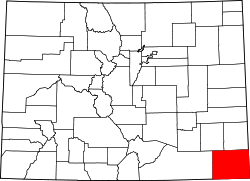
 Location within Baca County and Colorado | |
| Coordinates: 37°33′38.39″N102°23′47.6″W / 37.5606639°N 102.396556°W [1] | |
| Country | United States |
| State | Colorado |
| County | Baca County [2] |
| Incorporated | Oct 19, 1911 [3] |
| Government | |
| • Type | Statutory Town [2] |
| Area | |
• Total | 0.25 sq mi (0.64 km2) |
| • Land | 0.25 sq mi (0.64 km2) |
| • Water | 0 sq mi (0.00 km2) |
| Elevation | 4,105 ft (1,251 m) |
| Population | |
• Total | 34 |
| • Density | 140/sq mi (53/km2) |
| Time zone | UTC−7 (MST) |
| • Summer (DST) | UTC−6 (MDT) |
| ZIP Code | 81084 |
| Area code | 719 |
| FIPS code | 08-79270 [1] |
| GNIS ID | 2413409 [1] |
| Website | Town of Two Buttes |
Two Buttes is a statutory town located in Baca County, Colorado, United States. [1] The population was 34 at the 2020 census. [5]