Walsh, Colorado

Last updated

Walsh, Colorado
Walsh, Colorado.JPG
Entering from the west on Highway 160 (2019).
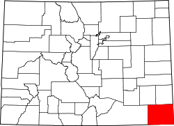
Baca County Colorado Incorporated and Unincorporated areas Walsh Highlighted 0882460.svg
Location of Walsh in Baca County, Colorado.
Coordinates: 37°23′12″N102°16′43″W / 37.38667°N 102.27861°W / 37.38667; -102.27861
CountryFlag of the United States.svg United States
State Flag of Colorado.svg  Colorado
County [1] Baca County
Incorporated July 19, 1928 [2]
Government
  Type Statutory Town [1]
Area
[3]
  Total0.45 sq mi (1.16 km2)
  Land0.45 sq mi (1.16 km2)
  Water0.00 sq mi (0.00 km2)
Elevation
[4]
3,953 ft (1,205 m)
Population
 (2020) [5]
  Total543
  Density1,200/sq mi (470/km2)
Time zone UTC−7 (Mountain (MST))
  Summer (DST) UTC−6 (MDT)
ZIP code [6]
81090
Area code 719
FIPS code 08-82460
GNIS feature ID 0196177
Website www.colorado.gov/townofwalsh

Walsh is a Statutory Town in Baca County, Colorado, United States. The population was 543 at the 2020 census. [5]

Contents

History

A post office called Walsh has been in operation since 1926. [7]

The community was named after one Mr. Walsh, a railroad official. [8]

Geography

Walsh is located in eastern Baca County at 37°23′12″N102°16′43″W / 37.38667°N 102.27861°W / 37.38667; -102.27861 (37.386540, -102.278727) [9] at an elevation of 3953'. U.S. Route 160 passes along the north edge of the town, leading west 20 miles (32 km) to Springfield, the county seat, and east 31 miles (50 km) to Johnson City, Kansas.

According to the United States Census Bureau, the town has a total area of 0.5 square miles (1.3 km2).

Climate

According to the Köppen Climate Classification system, Walsh has a cold semi-arid climate, abbreviated "BSk" on climate maps. The hottest temperature recorded in Walsh was 109 °F (42.8 °C) on July 17, 2022, while the coldest temperature recorded was −25 °F (−31.7 °C) on January 18, 1984. [10]

Climate data for Walsh, Colorado, 1991–2020 normals, extremes 1967–present
MonthJanFebMarAprMayJunJulAugSepOctNovDecYear
Record high °F (°C)80
(27)
85
(29)
89
(32)
96
(36)
102
(39)
108
(42)
109
(43)
106
(41)
105
(41)
98
(37)
88
(31)
78
(26)
109
(43)
Mean maximum °F (°C)69.0
(20.6)
73.3
(22.9)
81.9
(27.7)
87.4
(30.8)
94.3
(34.6)
101.2
(38.4)
103.0
(39.4)
100.3
(37.9)
97.0
(36.1)
90.1
(32.3)
78.5
(25.8)
69.6
(20.9)
104.0
(40.0)
Average high °F (°C)46.2
(7.9)
50.2
(10.1)
59.5
(15.3)
67.6
(19.8)
77.5
(25.3)
88.4
(31.3)
92.9
(33.8)
89.7
(32.1)
82.6
(28.1)
69.9
(21.1)
56.5
(13.6)
46.5
(8.1)
69.0
(20.5)
Daily mean °F (°C)32.6
(0.3)
35.7
(2.1)
44.1
(6.7)
52.2
(11.2)
62.3
(16.8)
73.0
(22.8)
77.7
(25.4)
75.3
(24.1)
67.7
(19.8)
54.5
(12.5)
42.3
(5.7)
33.1
(0.6)
54.2
(12.3)
Average low °F (°C)18.9
(−7.3)
21.3
(−5.9)
28.6
(−1.9)
36.7
(2.6)
47.1
(8.4)
57.6
(14.2)
62.5
(16.9)
61.0
(16.1)
52.8
(11.6)
39.2
(4.0)
28.2
(−2.1)
19.8
(−6.8)
39.5
(4.2)
Mean minimum °F (°C)0.5
(−17.5)
3.7
(−15.7)
10.9
(−11.7)
21.0
(−6.1)
32.6
(0.3)
45.4
(7.4)
53.5
(11.9)
52.2
(11.2)
38.1
(3.4)
22.3
(−5.4)
9.7
(−12.4)
1.0
(−17.2)
−4.8
(−20.4)
Record low °F (°C)−25
(−32)
−24
(−31)
−6
(−21)
8
(−13)
24
(−4)
38
(3)
45
(7)
41
(5)
20
(−7)
7
(−14)
−9
(−23)
−20
(−29)
−25
(−32)
Average precipitation inches (mm)0.46
(12)
0.40
(10)
1.06
(27)
1.65
(42)
2.12
(54)
2.60
(66)
3.57
(91)
3.26
(83)
1.43
(36)
1.64
(42)
0.58
(15)
0.76
(19)
19.53
(497)
Average snowfall inches (cm)4.5
(11)
3.4
(8.6)
4.2
(11)
1.8
(4.6)
0.2
(0.51)
0.0
(0.0)
0.0
(0.0)
0.0
(0.0)
0.0
(0.0)
1.0
(2.5)
2.6
(6.6)
5.3
(13)
23.0
(58)
Average extreme snow depth inches (cm)4.3
(11)
3.0
(7.6)
3.0
(7.6)
1.7
(4.3)
2.4
(6.1)
0.0
(0.0)
0.0
(0.0)
0.0
(0.0)
0.0
(0.0)
0.8
(2.0)
2.2
(5.6)
4.4
(11)
8.3
(21)
Average precipitation days (≥ 0.01 in)3.43.25.36.78.37.69.18.05.15.23.94.270.0
Average snowy days (≥ 0.1 in)2.82.22.20.80.10.00.00.00.00.51.42.912.9
Source 1: NOAA [11]
Source 2: National Weather Service [10] ×

Demographics

Historical population
CensusPop.Note
1930 454
1940 406−10.6%
1950 897120.9%
1960 856−4.6%
1970 98915.5%
1980 884−10.6%
1990 692−21.7%
2000 7234.5%
2010 546−24.5%
2020 543−0.5%
U.S. Decennial Census

See also

Related Research Articles

<span class="mw-page-title-main">Baca County, Colorado</span> County in Colorado, United States

Baca County is a county located in the U.S. state of Colorado. As of the 2020 census, the population was 3,506. The county seat is Springfield. Located at the southeast corner of Colorado, the county shares state borders with Kansas, New Mexico, and Oklahoma.

<span class="mw-page-title-main">Campo, Colorado</span> Town in Colorado, United States

Campo is a Statutory Town located in Baca County, Colorado, United States. The town population was 103 at the 2020 United States Census. The town is situated on the High Plains, straddling U.S. Route 287/385.

<span class="mw-page-title-main">Pritchett, Colorado</span> Town in Colorado, United States

Pritchett is a Statutory Town in Baca County, Colorado, United States. The population was 112 at the 2020 census.

<span class="mw-page-title-main">Springfield, Colorado</span> Town in Colorado, United States

Springfield is a Statutory Town which is also the county seat and most populous town in Baca County, Colorado, United States. The population was 1,325 at the 2020 census.

<span class="mw-page-title-main">Two Buttes, Colorado</span> Town in Colorado, United States

Two Buttes is a Statutory Town located in Baca County, Colorado, United States. The population was 34 at the 2020 census.

<span class="mw-page-title-main">Vilas, Colorado</span> Town in Colorado, United States

Vilas is a statutory town located in Baca County, Colorado, United States. The population was 98 at the 2020 census.

<span class="mw-page-title-main">Blanca, Colorado</span> Town in Colorado, United States

Blanca is a Statutory Town located in Costilla County, Colorado, United States. The town population was 322 at the 2020 census. Blanca is located in the enormous San Luis Valley.

<span class="mw-page-title-main">Rico, Colorado</span> Town in Colorado, United States

Rico is an incorporated small town in Dolores County, Colorado, United States. It was settled in 1879 as a silver mining center in the Pioneer Mining District; today it functions as a historic and tourism site. The population was 288 at the 2020 census. Its current form of government is that of a home rule municipality.

<span class="mw-page-title-main">Silt, Colorado</span> Town in Colorado, United States

Silt is a statutory town in Garfield County, Colorado, United States. The population was 3,536 at the 2020 census, up from 2,930 at the 2010 census.

<span class="mw-page-title-main">Walden, Colorado</span> Town in Jackson County, Colorado, United States

Walden is the Statutory Town that is the county seat, the most populous community, and the only incorporated municipality in Jackson County, Colorado, United States. It is situated in the center of a large open valley called North Park. People from Walden and the surrounding area refer to themselves as "North Parkers". The town population was 606 at the 2020 census. The town sits at an elevation of 8,099 feet. It was established in 1889 and was incorporated 2 December 1890. Mark A. Walden, an early postmaster, gave the community his name.

<span class="mw-page-title-main">Sheridan Lake, Colorado</span> Town in Colorado, United States

Sheridan Lake is a Statutory Town located in Kiowa County, Colorado, United States. The population was 55 at the 2020 census.

<span class="mw-page-title-main">Seibert, Colorado</span> Town in Kit Carson County, Colorado, United States

Seibert is a statutory town in Kit Carson County, Colorado, United States. The population was 172 at the 2020 census.

<span class="mw-page-title-main">Kim, Colorado</span> Town in Colorado, United States

Kim is a Statutory Town in Las Animas County, Colorado, United States. The population was 63 at the time of the 2020 United States Census.

<span class="mw-page-title-main">Crook, Colorado</span> Town in Colorado, United States

The Town of Crook is a Statutory Town in Logan County, Colorado, United States. The town population was 133 at the 2020 United States Census. Crook is a part of the Sterling, CO Micropolitan Statistical Area.

<span class="mw-page-title-main">Rye, Colorado</span> Town in Colorado, United States

Rye is a Statutory Town in Pueblo County, Colorado, United States. The population was 206 at the 2020 census.

<span class="mw-page-title-main">Ophir, Colorado</span> Town in San Migel County, Colorado, United States

The historic mining town of Ophir is a home rule municipality governed by a general assembly and is located in San Miguel County, Colorado, United States. Ophir is located two miles from the Ames Hydroelectric Generating Plant, the world's first hydroelectric plant to supply alternating current electricity for an industrial purpose (mining). The population was 197 at the 2020 census.

<span class="mw-page-title-main">Sedgwick, Colorado</span> Town in Colorado, United States

Sedgwick is a statutory town in Sedgwick County, Colorado, United States. The population was 172 at the 2020 census.

<span class="mw-page-title-main">Otis, Colorado</span> Town in Colorado, United States

Otis is a Statutory Town in Washington County, Colorado, United States. The population was 511 at the 2020 census.

<span class="mw-page-title-main">Eckley, Colorado</span> Town in Colorado, United States

Eckley is a statutory town located in Yuma County, Colorado, United States. The town population was 232 at the 2020 United States Census.

<span class="mw-page-title-main">Wray, Colorado</span> City in Colorado, United States

Wray is the home rule municipality that is the county seat of Yuma County, Colorado, United States. Located in the Colorado Plains, the city is 170 miles east of Denver, 9 miles west of the Nebraska state line, and 25 miles northwest of the Kansas state line. The population was 2,358 at the 2020 United States census.

References

  1. 1 2 "Active Colorado Municipalities". State of Colorado, Department of Local Affairs. Archived from the original on December 12, 2009. Retrieved September 1, 2007.
  2. "Colorado Municipal Incorporations". State of Colorado, Department of Personnel & Administration, Colorado State Archives. December 1, 2004. Retrieved September 2, 2007.
  3. "2019 U.S. Gazetteer Files". United States Census Bureau. Retrieved July 1, 2020.
  4. "US Board on Geographic Names". United States Geological Survey. October 25, 2007. Retrieved January 31, 2008.
  5. 1 2 United States Census Bureau. "Walsh town; Colorado" . Retrieved April 29, 2023.
  6. "ZIP Code Lookup". United States Postal Service. Archived from the original (JavaScript/HTML) on September 3, 2007. Retrieved January 8, 2008.
  7. "Post offices". Jim Forte Postal History. Retrieved July 11, 2016.
  8. Dawson, John Frank. Place names in Colorado: why 700 communities were so named, 150 of Spanish or Indian origin. Denver, CO: The J. Frank Dawson Publishing Co. p. 51.
  9. "US Gazetteer files: 2010, 2000, and 1990". United States Census Bureau. February 12, 2011. Retrieved April 23, 2011.
  10. 1 2 "NOAA Online Weather Data - NWS Pueblo". National Weather Service. Retrieved November 1, 2022.
  11. "U.S. Climate Normals Quick Access - Station: Walsh 1W, CO". National Oceanic and Atmospheric Administration. Retrieved November 1, 2022.