Buckeye Crossroads, Colorado

Last updated
Buckeye Crossroads, Colorado
Usa edcp location map.svg
Red pog.svg
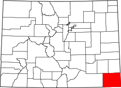
Buckeye Crossroads
Location of Buckeye Crossroads, Colorado.
USA Colorado location map.svg
Red pog.svg
Buckeye Crossroads
Buckeye Crossroads (Colorado)
Coordinates: 37°33′27″N102°07′44″W / 37.5575°N 102.1288°W / 37.5575; -102.1288 (Buckeye Crossroads, Colorado) [1]
Country United States
State Colorado
County Baca County [2]
Government
  Type unincorporated community
  Body Baca County [2]
Elevation
[1]
3,763 ft (1,147 m)
Time zone UTC−07:00 (MST)
  Summer (DST) UTC−06:00 (MDT)
Area code 719
GNIS pop ID 203955

Buckeye Crossroads is an unincorporated community in eastern Baca County, Colorado, United States. [1] It is located at the intersection of Colorado State highways 89 and 116. Springfield, Colorado is approximately 37 driving miles east-northeast. [3] Buckeye Crossroads had a population of only 7 in 2000.[ citation needed ] Buckeye Crossroads never had a post office. [4]

Contents

Geography

The community is just over 5 miles from the state border with Kansas. [5]

See also

Related Research Articles

<span class="mw-page-title-main">Brighton, Colorado</span> City in Colorado, United States

Brighton is a home rule municipality city located in Adams and Weld counties, Colorado, United States. Brighton is the county seat of Adams County and a part of the Denver–Aurora–Lakewood, CO Metropolitan Statistical Area and the Front Range Urban Corridor. The city population was 40,083 at the 2020 United States Census with 39,718 residing in Adams County and 365 residing in Weld County.

<span class="mw-page-title-main">Walsh, Colorado</span> Town in Colorado, United States

Walsh is a statutory town in Baca County, Colorado, United States. The population was 543 at the 2020 census.

<span class="mw-page-title-main">Blanca, Colorado</span> A Statutory Town in Costilla County, Colorado, United States.

Blanca is a Statutory Town located in Costilla County, Colorado, United States. The town population was 322 at the 2020 census. Blanca is located in the enormous San Luis Valley.

<span class="mw-page-title-main">Ordway, Colorado</span> Town in and county seat of Crowley County, Colorado, United States

Ordway is a statutory town in and the county seat of Crowley County, Colorado, United States, that is also the most populous community in the county. The population was 1,066 at the 2020 census.

<span class="mw-page-title-main">Brookside, Colorado</span> A Statutory Town in Fremont County, Colorado, United States

Brookside is a Statutory Town located in Fremont County, Colorado, United States. The town population was 236 at the 2020 United States Census.

<span class="mw-page-title-main">Aspen Park, Colorado</span> A Census Designated Place in Jefferson County, Colorado, United States

Aspen Park is an unincorporated community and a census-designated place (CDP) located in Jefferson County, Colorado, United States. The CDP is a part of the Denver–Aurora–Lakewood, CO Metropolitan Statistical Area. The population of the Aspen Park CDP was 810 at the United States Census 2020. The Aspen Park Metropolitan District provides services. The Conifer post office serves the area.

<span class="mw-page-title-main">Sheridan Lake, Colorado</span> Town in Colorado, United States

Sheridan Lake is a statutory town located in Kiowa County, Colorado, United States. The population was 55 at the 2020 census.

<span class="mw-page-title-main">Bayfield, Colorado</span> A Statutory Town in La Plata County, Colorado, United States

Bayfield is a Statutory Town located in La Plata County, Colorado, United States. The town population was 2,838 at the 2020 United States Census, a +21.65% increase since the 2010 United States Census. Bayfield is part of the Durango, CO Micropolitan Statistical Area.

<span class="mw-page-title-main">Ignacio, Colorado</span> Town in Colorado, United States

The Town of Ignacio is a Statutory Town in La Plata County, Colorado, United States. The population was 852 at the 2020 United States Census. Ignacio is the headquarters of the Southern Ute Indian Reservation.

<span class="mw-page-title-main">Atwood, Colorado</span> Census Designated Place in State of Colorado, United States of America

Atwood is an unincorporated town, a post office, and a census-designated place (CDP) located in Logan County, Colorado, United States. The CDP is a part of the Sterling, CO Micropolitan Statistical Area. At the United States Census 2020, the population of the Atwood CDP was 138.

<span class="mw-page-title-main">Brush, Colorado</span> A Statutory City in Morgan County, Colorado, United States.

Brush is a Statutory City located in Morgan County, Colorado, United States. The city population was 5,339 at the 2020 United States Census. Brush is a part of the Fort Morgan, CO Micropolitan Statistical Area.

<span class="mw-page-title-main">Buckeye, Colorado</span> An unincorporated community in Larimer County, Colorado, United States.

Buckeye is a farming and ranching unincorporated community in north central Larimer County, Colorado, United States. Bounded on the west by the 16,500-acre (67 km2) Roberts Ranch, the area includes Red Mountain Open Space to the north, Rawhide flats to the east, and extends south to Owl Canyon.

<span class="mw-page-title-main">Bedrock, Colorado</span> An unincorporated community in Montrose County, Colorado, United States

Bedrock is an unincorporated community and U.S. post office in western Montrose County, Colorado, United States. The ZIP code of Bedrock is 81411.

<span class="mw-page-title-main">Brandon, Colorado</span> A Census Designated Place in Kiowa County, Colorado, United States

Brandon is a census-designated place (CDP) located in Kiowa County, Colorado, United States. The population of the Brandon CDP was 21 at the United States Census 2020.

Deora is an unincorporated community in Baca County, Colorado, United States.

<span class="mw-page-title-main">Lycan, Colorado</span> Unincorporated community in Colorado, United States

Lycan is an unincorporated community in Baca County, Colorado, United States. It is located approximately 37 driving miles east-northeast of Springfield.

<span class="mw-page-title-main">Altona, Colorado</span> A census-designated place in Boulder County, Colorado, United States

Altona is an unincorporated community and a census-designated place (CDP) located in and governed by Boulder County, Colorado, United States. The CDP is a part of the Boulder, CO Metropolitan Statistical Area. The population of the Altona CDP was 512 at the United States Census 2020. The Boulder post office serves the area.

<span class="mw-page-title-main">Antero Junction, Colorado</span> Ghost town in State of Colorado, United States of America

Antero Junction is an extinct town located in Park County, Colorado, United States. The townsite is located at coordinates 38.9233°N 105.9653°W} at an elevation of 9,187 feet. Antero Junction is located at the junction of U.S. Route 285 and U.S. Route 24.

<span class="mw-page-title-main">Oxford, Colorado</span> An unincorporated community in La Plata County, Colorado, United States.

Oxford is an unincorporated community on the Southern Ute Indian Reservation in La Plata County, Colorado, United States.

<span class="mw-page-title-main">Brook Forest, Colorado</span> Census Designated Place in Colorado, United States

Brook Forest is an unincorporated community and a census-designated place (CDP) located in Jefferson and Clear Creek counties, Colorado, United States. The population was 622 at the 2020 census. The CDP is a part of the Denver–Aurora–Lakewood, CO Metropolitan Statistical Area.

References

  1. 1 2 3 "Buckeye Crossroads, Colorado". Geographic Names Information System . United States Geological Survey, United States Department of the Interior . Retrieved February 3, 2025.
  2. 1 2 "Colorado Counties". Colorado Department of Local Affairs . Retrieved February 3, 2025.
  3. "Springfield, Colorado to Buckeye Crossroads, Colorado". Google Maps. Retrieved December 10, 2020.
  4. Bauer, William H.; Ozment, James L.; Willard, John H. (1990). Colorado Post Offices 1859–1989. Golden, Colorado: Colorado Railroad Historical Foundation. ISBN   0-918654-42-4.
  5. "Co Rd 57, Holly, CO to Buckeye Crossroads, Colorado". Google Maps. Retrieved December 10, 2020.