Dominica is an island in the Caribbean Sea, located about halfway between the French islands of Guadeloupe and Martinique. Its coordinates are 15 25 N, 61 20 W. It is known as "The Nature Island of the Caribbean" due to its spectacular, lush, and varied flora and fauna, which is protected by an extensive natural park system. It is the fourth largest island in the Eastern Caribbean with a population of people mainly of African descent.

Roseau is the capital and largest city of Dominica, with a population of 16,571 as of 2023. It is a small and compact urban settlement, in the Saint George parish and surrounded by the Caribbean Sea, the Roseau River and Morne Bruce. Built on the site of the ancient Island Carib village of Sairi, it is the oldest and most important urban settlement on the island of Dominica.
Salisbury is a town on the west coast of the small Caribbean island nation of Dominica. It is located at 15°26′9″N61°26′13″W and is a part of the country's St. Joseph administrative division. Its population is 2,129.
The culture of Dominica is formed by the inhabitants of the Commonwealth of Dominica. Dominica is home to a wide range of people. Although it was historically occupied by several native tribes, it was the Taíno and Island Caribs (Kalinago) tribes that remained by the time European settlers reached the island. "Massacre" is a name of a river dedicated to the murders of the native villagers by both French and British settlers, because the river "ran red with blood for days." Each claimed the island and imported slaves from Africa. The remaining Caribs now live on a 3,700-acre (15 km2) Carib Territory on the east coast of the island. They elect their own chief.

Dame Mary Eugenia Charles, was a Dominican politician who was Prime Minister of Dominica from 21 July 1980 until 14 June 1995. The first female lawyer in Dominica, she was Dominica's first, and to date only, female prime minister. She was the second female prime minister in the Caribbean after Lucina da Costa of the Netherlands Antilles. She was the first female in the Americas to be elected in her own right as head of government. She served for the second longest period of any Dominican prime minister, and was the world's fourth longest-serving female Prime Minister, behind Sheikh Hasina of Bangladesh, Sirimavo Bandaranaike of Sri Lanka and Indira Gandhi of India.

Saint Andrew is one of Dominica's 10 administrative parishes. It is bordered by St. John and St. Peter, St. Joseph, and St. David.
Cadence-lypso is a fusion of cadence rampa from Haiti and calypso from Trinidad and Tobago that has also spread to other English speaking countries of the Caribbean. Originated in the 1970s by the Dominican band Exile One, it spread and became popular in the dance clubs around the Creole world and Africa as well as the French Antilles.

Wesley is a village in Saint Andrew Parish in north-eastern Dominica. It situated between the old estates of Eden and Londonderry and 1 1/2 miles southeast of Woodford Hill. Like many other villages along the east coast Wesley developed after Emancipation on hilly land along the boundary between the two estates as labourers sought to establish independent holdings for themselves away from the plantations where they had formerly lived and worked.

Colihaut is a coastal village in northern Dominica within Saint Peter Parish midway between the towns of Roseau and Portsmouth. It has a population of 773 people.

Scotts Head is a village on the southwest coast of Dominica, in Saint Mark Parish. In 2001, its population was 721. Predominantly a fishing village, Scotts Head overlooks Soufrière Bay, which is protected as the Soufrière Scotts Head Marine Reserve. It is also a popular snorkeling and diving site for tourists.
Petite Savanne was a village on the southeast side of Dominica. It had an estimated population of 1,200 in 2015. The region the town was built on features some of Dominica's steepest terrain; the slopes were composed largely of silt and clay.
Calibishie is a village in Dominica, located on the north-east coast of the island, immediately to the east of the village of Hampstead. The Calibishie Coast Travel Area is thought by many to be the most scenic and unspoiled region of Dominica. The Calibishie coast is one of the few areas in the world where the distance from the seashore to rain forest is little more than a mile. Calibishie is home to Dominica's Batibou, Hampstead, Hodges, Point Baptiste, Turtle and Woodford Hill Beaches.
Pont Cassé is situated in the Saint Paul Parish in Dominica. It is located almost in the middle of Dominica, close to Belles Village northeast of the national capital, Roseau, and close to Morne Trois Pitons, the mountain which dominates the southern center of the country. As of 2006 it has a population of 100.

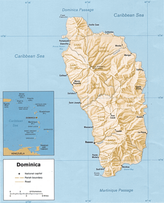
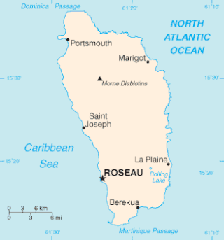
Dominica, officially the Commonwealth of Dominica, is an island country in the Caribbean. The capital, Roseau, is located on the western side of the island. It is geographically situated as part of the Windward Islands chain in the Lesser Antilles archipelago in the Caribbean Sea. Dominica's closest neighbours are two constituent territories of the European Union, the overseas departments of France, Guadeloupe to the northwest and Martinique to the south-southeast. Dominica comprises a land area of 750 km2 (290 sq mi), and the highest point is Morne Diablotins, at 1,447 m (4,747 ft) in elevation. Its population was 71,293 at the 2011 census.
The following outline is provided as an overview of and topical guide to Dominica:

The most common religion in Dominica is Christianity, with a majority of practitioners identifying as Roman Catholic. Various minority religious groups are also present on the island.

Dominica Botanic Gardens is located on the Caribbean island-nation of Dominica, in the capital of Roseau. Once known as one of the finest botanical gardens in the region, it was severely damaged by Hurricane David in 1979. Following restoration efforts, it remains a focus of cultural life in Roseau, and a center of conservation research on Dominica.

Tropical Storm Erika was one of the deadliest and most destructive natural disasters in Dominica since Hurricane David in 1979. The fifth named storm of the 2015 Atlantic hurricane season, Erika developed from a westward-moving tropical wave while well east of the Lesser Antilles. Hostile conditions, including dry air and wind shear, inhibited significant development, and Erika failed to acquire sustained winds beyond 50 mph (80 km/h). Contrary to predictions of a northwesterly recurvature, the cyclone persisted on a westerly course and passed through the Leeward Islands and emerged over the Caribbean Sea on August 27. Erika succumbed to adverse conditions the following day, dissipating as a tropical cyclone near the Dominican Republic. The remnant system persisted for several more days, moving into the northeastern Gulf of Mexico, before dissipating over Georgia on September 3.

Dominica is an island nation in the Windward islands in the Lesser Antilles archipelago in the Caribbean Sea. Most people arrive in Dominica via Douglas–Charles Airport, where most commercial flights to the island land. Dominica also utilizes sea transport and a roadway network.
Doreen Paul was a Dominican banker who served in politics from 1990 to 2000. She was particularly involved, as the Minister of Health and Social Security, in the development of infrastructure improvement projects including health centers, sports complexes, roads and water systems.
