Dominica is an island in the Caribbean Sea, located about halfway between the French islands of Guadeloupe and Martinique. Its coordinates are 15 25 N, 61 20 W. It is known as "The Nature Island of the Caribbean" due to its spectacular, lush, and varied flora and fauna, which is protected by an extensive natural park system. It is the fourth largest island in the Eastern Caribbean with a population of people mainly of African descent.

Roseau is the capital and largest city of Dominica, with a population of 14,725 as of 2011. It is a small and compact urban settlement, in the Saint George parish and surrounded by the Caribbean Sea, the Roseau River and Morne Bruce. Built on the site of the ancient Island Carib village of Sairi, it is the oldest and most important urban settlement on the island of Dominica.

Morne Diablotin is the highest mountain in Dominica, an island-nation in the Caribbean Lesser Antilles. It is the second highest mountain in the Lesser Antilles, after La Grande Soufrière in Guadeloupe. Morne Diablotin is located in the northern interior of the island, about 24 kilometres (15 mi) north of Dominica's capital Roseau and about 10 kilometres (6.2 mi) southeast of Portsmouth, the island's second-largest town. It is located within Morne Diablotin National Park.

Saint John is one of Dominica's 10 administrative parishes. It is bordered by St. Andrew to the east, and St. Peter and the Espagnole River to the south. It has an area of 59 km2 (22.78 mi2).
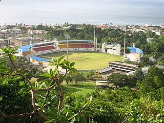
Windsor Park is a multi-purpose stadium in Roseau in Dominica. It serves as the country's national stadium and is used mostly for cricket and association football matches. Other uses have included the World Creole Music Festival, the Finals of the Calypso Competition and the Miss Dominica pageant.
Lennox Honychurch is a Dominican historian and politician. He wrote 1975's The Dominica Story: A History of the Island, the 1980s textbook series The Caribbean People, and the 1991 travel book Dominica: Isle of Adventure. Also an artist and a curator, he was largely responsible for compiling the exhibit information for The Dominica Museum in Roseau. Honychurch is the grandson of writer and politician Elma Napier.

Cabrits National Park is on a peninsula at the north end of the Caribbean island of Dominica, north of Portsmouth. The park protects tropical forest, coral reefs and wetlands. There are hiking trails and an English garrison called Fort Shirley.

Colihaut is a coastal village in northern Dominica within Saint Peter Parish midway between the towns of Roseau and Portsmouth. It has a population of 773 people.
Petite Savanne was a village on the southeast side of Dominica. It had an estimated population of 1,200 in 2015. The region the town was built on features some of Dominica's steepest terrain; the slopes were composed largely of silt and clay.
Canefield is a town located on the west coast of Dominica, north of Roseau and south of Massacre, overlooking Pringle's Bay. The largest settlement in St. Paul Parish, it has a population of 2,803. It is home to an industrial estate with Harris Paints Dominica Ltd., a branch of the Jehovah's Witnesses, the Old Mill Cultural Center and Museum as well as the island's second airport. Neighboring locales include Cochrane, Checkhall, Massacre and Fond Colé.

Calibishie is a village in Dominica, located on the north-east coast of the island, immediately to the east of the village of Hampstead. The Calibishie Coast Travel Area is thought by many to be the most scenic and unspoiled region of Dominica. The Calibishie coast is one of the few areas in the world where the distance from the seashore to rain forest is little more than a mile. Calibishie is home to Dominica's Batibou, Hampstead, Hodges, Point Baptiste, Turtle and Woodford Hill Beaches.

Massacre is a town in Saint Paul Parish, Dominica, with about 1,200 inhabitants. It is located on the central west coast of the island, to the north of the capital, Roseau, on the Massacre River.

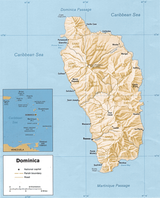
Dominica, officially the Commonwealth of Dominica, is an island country in the Caribbean. It is part of the Windward Islands chain in the Lesser Antilles archipelago in the Caribbean Sea. The capital, Roseau, is located on the western side of the island. Dominica's closest neighbours are two constituent territories of the European Union, both overseas departments of France: Guadeloupe to the northwest and Martinique to the south-southeast. Dominica comprises a land area of 750 km2 (290 sq mi), and the highest point is Morne Diablotins, at 1,447 m (4,747 ft) in elevation. The population was 71,293 at the 2011 census.
Penville or Pennville is a village in Dominica's Saint Andrew Parish. The community is situated just north of Vieille Case, and has a population of 524.
Tourism in Dominica consists mostly of hiking in the rain forest and visiting cruise ships.

The Invasion of Dominica was a successful French invasion of the island of Dominica in the British West Indies, during the American Revolutionary War. The action took place before British authorities in the Caribbean were aware that France had entered the war as an ally of the United States of America. The French governor in the West Indies, François Claude Amour, marquis de Bouillé, was notified on 17 August that France was at war, and organized the invasion, infiltrating spies to rally sympathetic French-speaking Dominican support.
Picard is a community on the northwest side of Dominica. It is part of Portsmouth, Dominica.
Benjamin's Park is a sporting venue in Portsmouth, Dominica, located 30 miles (48 km) away from the capital, Roseau. The venue's primary use is as a cricket ground, and it has held home matches for the Windward Islands, as well as several matches in regional tournaments.
Belles is a small village in the Caribbean island nation of Dominica. It is located at 15°27′12.7″N61°19′11.4″W and is a part of the country's St. Joseph administrative division. Its population is 500. Belles is a historical site for a few reasons. It is a major part of the highway system to the northern part of the island. The roads were blocked many years ago by Rastafarians who were not happy with the government. Many of them escaped to Jaco Flats and used it for refuge. This is a site that was used by the Maroons hundreds of years ago. As of 2016, the Esprit and Benjamin families own and control a majority of the private land.

Fort Shirley is a historic military outpost on the Caribbean island of Dominica. It was built by the British in 1765, and was named for Sir Thomas Shirley. The fort was the location of the 1802 revolt of the 8th West India Regiment. Today, Fort Shirley is part of Cabrits National Park, which was established as a national park in 1986.

