
Salisbury is a town on the west coast of the small Caribbean island nation of Dominica. It is located at 15°26′9″N61°26′13″W and is a part of the country's St. Joseph administrative division. Its population is 2,129.
Area code 767 is the local telephone area code of the Commonwealth of Dominica, within the North American Numbering Plan. Area 767 was created with the start of permissive dialing on 1 October 1997, ending 30 September 1998, as a split from area 809, which formerly covered 19 Caribbean territories. The number 767 corresponds to the letters ROS and may be mnemonic for Roseau, Dominica's capital city.
Portsmouth is the second largest town in Dominica, with 2,977 inhabitants. It lies on the Indian River on Dominica's northwest coast, in Saint John Parish. Cabrits National Park is located on a peninsula to the north of town. Portsmouth has its own sea port in Prince Rupert Bay.
La Plaine is a village located on the eastern side of the island of Dominica. It has a population of 1,288, and is the second-largest settlement in Saint Patrick Parish.

Colihaut is a coastal village in northern Dominica within Saint Peter Parish midway between the towns of Roseau and Portsmouth. It has a population of 773 people.
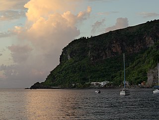
Scotts Head is a village on the southwest coast of Dominica, in Saint Mark Parish. In 2001, its population was 721. Predominantly a fishing village, Scotts Head overlooks Soufrière Bay, which is protected as the Soufrière Scotts Head Marine Reserve. It is also a popular snorkeling and diving site for tourists.

Marigot is the largest settlement of Saint Andrew Parish in northeastern Dominica. The village has a population of 2,676 people, and is home to a Fisheries Complex as well as the island's main airport. It is the birthplace of local politician Edison James, and cricket umpire Billy Doctrove.

Mahaut is a village on the west coast of Dominica. It has a population of 2,399, and is home to Dominica Colgate-Palmolive until, the factory was closed in 2015 after Hurricane Erica.

Goshen is a Canadian rural community in Guysborough County, Nova Scotia.
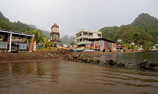
Soufrière is a village on the southwest coast of Dominica. It is the capital of Saint Mark Parish and has a population of 1,416 people.

Hampstead is a village in northeastern Dominica. Along with Bense, the area has a population of 495, and was used as a filming location for 2006's Pirates of the Caribbean: Dead Man's Chest.
Wotten Waven is a village in Dominica's Roseau Valley. It has a population of 226 people.

Saint Joseph is the chief settlement of Dominica's St. Joseph Parish. Its population is 2,029.

Galion, also spelled Gallion, is a mountain village in the south of Dominica, with a population of 134.

Castle Bruce is a village on the east coast of Dominica. It is the largest settlement in St. David Parish, with a population of 1,339.
Canefield is a town located on the west coast of Dominica, north of Roseau and south of Massacre, overlooking Pringle's Bay. The largest settlement in St. Paul Parish, it has a population of 2,803. It is home to an industrial estate with Harris Paints Dominica Ltd., a branch of the Jehovah's Witnesses, as well as the island's second airport. Neighbouring locales include Cochrane, Checkhall, Massacre and Fond Colé.
Paix Bouche is a village in northern Dominica. It has a population of 306, and has one of the island's steepest roads. The name comes from the local Creole expression meaning "shut your mouth".
Penville or Pennville is a village in Dominica's Saint Andrew Parish. The community is situated just north of Vieille Case, and has a population of 524.
Coulibistrie is a village on the west coast of Dominica, in the northwest corner of Saint Joseph Parish. It is between the villages of Colihaut to the north and Morne Rachette to the south. It extends inland from the coast within a deep valley, along both banks of the Coulibistrie River. It is primarily residential with few businesses. Many of the houses are built directly atop or adjoining the numerous large boulders that litter the valley along its base.
Belles is a small village in the Caribbean island nation of Dominica. It is located at 15°27′12.7″N61°19′11.4″W and is a part of the country's St. Joseph administrative division. Its population is 500. Belles is a historical site for a few reasons. It is a major part of the highway system to the northern part of the island. The roads were blocked many years ago by Rastafarians who were not happy with the government. Many of them escaped to Jaco Flats and used it for refuge. This is a site that was used by the Maroons hundreds of years ago. As of 2016, the Esprit and Benjamin families own and control a majority of the private land.

