
Roseau is the capital and largest city of Dominica, with a population of 14,725 as of 2011. It is a small and compact urban settlement, in the Saint George parish and surrounded by the Caribbean Sea, the Roseau River and Morne Bruce. Built on the site of the ancient Island Carib village of Sairi, it is the oldest and most important urban settlement on the island of Dominica.

Stronsay is an island in Orkney, Scotland. It is known as Orkney's 'Island of Bays', owing to an irregular shape with miles of coastline, with three large bays separated by two isthmuses: St Catherine's Bay to the west, the Bay of Holland to the south and Mill Bay to the east. Stronsay is 3,275 hectares in area, and 44 metres in altitude at its highest point. It has a usually resident population of 349. The main village is Whitehall, home to a heritage centre.
Red Bay is a fishing village in Labrador, notable as one of the most precious underwater archaeological sites in the Americas. Between 1530 and the early 17th century, it was a major Basque whaling area. Several whaling ships, both large galleons and small chalupas, sank there, and their discovery led to the designation of Red Bay in 2013 as a UNESCO World Heritage Site.
Salisbury is a town on the west coast of the small Caribbean island nation of Dominica. It is located at 15°26′9″N61°26′13″W and is a part of the country's St. Joseph administrative division. Its population is 2,129.

Saint Andrew is one of Dominica's 10 administrative parishes. It is bordered by St. John and St. Peter, St. Joseph, and St. David.

Portsmouth is the second largest town in Dominica, with 3,630 inhabitants. It is located on the shore of a natural Harbor, Prince Rupert Bay, in Saint John Parish on the north-west coast of Dominica. The area was called Ouyouhao by the Kalinago and Grand Anse by the French. The Indian River is Portsmouth’s southern border and Cabrits National Park is located on a peninsula to the north of town.
Keels is a small town in the Canadian province of Newfoundland and Labrador, located about 3 kilometres from Duntara. The population of this municipality in the 2016 Canadian National Census was 51. This is down from 61 in 2011 and 73 in 2006. The earlier population figures show it had 85 in 2001, 101 in 1996, 128 in 1991, 115 in 1986, 206 in 1956 and 372 in 1940.
La Plaine is a village located on the eastern side of the island of Dominica. It has a population of 1,288, and is the second-largest settlement in Saint Patrick Parish.

Wesley is a village in Saint Andrew Parish in north-eastern Dominica. It situated between the old estates of Eden and Londonderry and 1 1/2 miles southeast of Woodford Hill. Like many other villages along the east coast, Wesley developed after Emancipation on hilly land along the boundary between the two estates as labourers sought to establish independent holdings for themselves away from the plantations where they had formerly lived and worked.

Colihaut is a coastal village in northern Dominica within Saint Peter Parish midway between the towns of Roseau and Portsmouth. It has a population of 773 people.

Scotts Head is a village on the southwest coast of Dominica, in Saint Mark Parish. In 2001, its population was 721. Predominantly a fishing village, Scotts Head overlooks Soufrière Bay, which is protected as the Soufrière Scotts Head Marine Reserve. It is also a popular snorkeling and diving site for tourists.
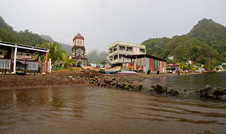
Soufrière is a village on the southwest coast of Dominica. It is the capital of Saint Mark Parish and has a population of 1,416 people.
Paix Bouche is a village in northern Dominica. It has a population of 306, and has one of the island's steepest roads. The name comes from the local Creole expression meaning "shut your mouth".
Calibishie is a village in Dominica, located on the north-east coast of the island, immediately to the east of the village of Hampstead. The Calibishie Coast Travel Area is thought by many to be the most scenic and unspoiled region of Dominica. The Calibishie coast is one of the few areas in the world where the distance from the seashore to rain forest is little more than a mile. Calibishie is home to Dominica's Batibou, Hampstead, Hodges, Point Baptiste, Turtle and Woodford Hill Beaches.
Penville or Pennville is a village in Dominica's Saint Andrew Parish. The community is situated just north of Vieille Case, and has a population of 524.

Humber Arm South is a town in the Canadian province of Newfoundland and Labrador. The town consists of the communities of Halfway Point, Benoit's Cove, John's Beach, and Frenchman's Cove. The town had a population of 1,537 in the Canada 2021 Census. The Town's Post Office is located in Benoit's Cove. Humber Arm South is located in the Bay of Islands and is in the Humber-Bay of Islands electoral district. The town's residents are of Mi'kmaw, Innu, and European descent.
The Thibaud River is a river on the Caribbean island of Dominica.

Division No. 1, Subdivision G is an unorganized subdivision on the Avalon Peninsula in Newfoundland and Labrador, Canada. It is in Division 1 and contains the unincorporated communities of Baccalieu Island, Besom Cove, Bradley's Cove, Burnt Point, Caplin Cove, Daniel's Cove, Grates Cove, Gull Island, Job's Cove, Kingston, Long Beach, Lower Island Cove, Low Point, Northern Bay, Ochre Pit Cove, Red Head Cove, Riverhead, Smooth Cove and Western Bay.
Belles is a small village in the Caribbean island nation of Dominica. It is located at 15°27′12.7″N61°19′11.4″W and is a part of the country's St. Joseph administrative division. Its population is 500. Belles is a historical site for a few reasons. It is a major part of the highway system to the northern part of the island. The roads were blocked many years ago by Rastafarians who were not happy with the government. Many of them escaped to Jaco Flats and used it for refuge. This is a site that was used by the Maroons hundreds of years ago. As of 2016, the Esprit and Benjamin families own and control a majority of the private land.
Woodford Hill is a village in Saint Andrew Parish in north-eastern Dominica. Woodford Hill was an estate extending from Eden River to L’anse Noire. An Amerindian village existed at the mouth of the Woodford Hill river about 1,400 years ago. The present day village of Woodford Hill is on the western boundary of the old estate. It is made up of various sections including Small Farm, Mount Sylvie, Falang, Larieu, Fond Cole, Joe Road, and Big Cedar. According to the 2011 census report, Woodford Hill had a population of 1,034.