Massacre, Dominica

Last updated
Mural in Massacre depicting the 1674 massacre of the Kalinago (Carib) people by British troops. Wall painting massacre dominica.JPG
Mural in Massacre depicting the 1674 massacre of the Kalinago (Carib) people by British troops.
Dominica location map.svg
Red pog.svg
Massacre

Massacre is a town in Saint Paul Parish, Dominica, with about 1,200 inhabitants. It is located on the central west coast of the island, to the north of the capital, Roseau, on the Massacre River.

Contents

History

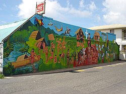
The town was named by the French after a massacre of Caribs carried out by the English that occurred in the area in 1674. [1] The massacre occurred in a settlement that was established by Thomas “Carib” Warner, the Kittitian-born son of the English colonizer Sir Thomas Warner and a Kalinago woman from Dominica. Warner was murdered by his own English half-brother, Phillip Warner. Following his murder, the people of the village he established were massacred. That village is now the present site of the village of Massacre. [2]

Related Research Articles

The first written records in the history of Dominica began in November 1493, when Christopher Columbus spotted the island. Prior to European contact, Dominica was inhabited by the Arawak. Dominica was a French colony from 1715 until the end of the Seven Years' War in 1763, and then became a British colony from 1763 to 1978. It became an independent nation in 1978.

<span class="mw-page-title-main">Kalinago</span> Group of people who live in Venezuela and the Lesser Antilles

The Kalinago, formerly known as Island Caribs or simply Caribs, are an indigenous people of the Lesser Antilles in the Caribbean. They may have been related to the Mainland Caribs (Kalina) of South America, but they spoke an unrelated language known as Island Carib. They also spoke a pidgin language associated with the Mainland Caribs.

<i>The Dominica Story</i> 1975 book by Lennox Honychurch

The Dominica Story: A History of the Island is a history book from 1975, written by Dominican historian Lennox Honychurch. It was the first published history of the island. Originally presented as a miniseries for Radio Dominica in 1974, the inaugural edition covered every aspect of local history from prehistory up to the then-present.

Lennox Honychurch is Dominica's most noted historian and a politician. He is well known for writing 1975's The Dominica Story: A History of the Island, the 1980s textbook series The Caribbean People, and the 1991 travel book Dominica: Isle of Adventure. Also an artist and a curator, he was largely responsible for compiling the exhibit information for The Dominica Museum in Roseau. Honychurch is the grandson of writer and politician Elma Napier.

<span class="mw-page-title-main">Portsmouth, Dominica</span> Town in Saint John Parish, Dominica

Portsmouth is the second largest town in Dominica, with 3,630 inhabitants. It is located on the shore of a natural Harbor, Prince Rupert Bay, in Saint John Parish on the north-west coast of Dominica. The area was called Ouyouhao by the Kalinago and Grand Anse by the French. The Indian River is Portsmouth’s southern border and Cabrits National Park is located on a peninsula to the north of town.

<span class="mw-page-title-main">Cabrits National Park</span>

Cabrits National Park is on a peninsula at the north end of the Caribbean island of Dominica, north of Portsmouth. The park protects tropical forest, coral reefs and wetlands. There are hiking trails and an English garrison called Fort Shirley. Cabrits National Park occupies 1,313 acres and was established in 1986.

<span class="mw-page-title-main">Wesley, Dominica</span> Place in Saint Andrew Parish, Dominica

Wesley is a village in Saint Andrew Parish in north-eastern Dominica. It situated between the old estates of Eden and Londonderry and 1 1/2 miles southeast of Woodford Hill. Like many other villages along the east coast Wesley developed after Emancipation on hilly land along the boundary between the two estates as labourers sought to establish independent holdings for themselves away from the plantations where they had formerly lived and worked.

<span class="mw-page-title-main">Scotts Head, Dominica</span> Lighthouse

Scotts Head is a village on the southwest coast of Dominica, in Saint Mark Parish. In 2001, its population was 721. Predominantly a fishing village, Scotts Head overlooks Soufrière Bay, which is protected as the Soufrière Scotts Head Marine Reserve. It is also a popular snorkeling and diving site for tourists.

<span class="mw-page-title-main">Rosalie, Dominica</span>

Rosalie is a village in Dominica. It is located in Saint David Parish at the northern end of Rosalie Bay, on the central east coast of the island, close to the mouth of the Rosalie River.

<span class="mw-page-title-main">Calibishie</span> Place in Saint Andrew Parish, Dominica

Calibishie is a village in Dominica, located on the north-east coast of the island, immediately to the east of the village of Hampstead. The Calibishie Coast Travel Area is thought by many to be the most scenic and unspoiled region of Dominica. The Calibishie coast is one of the few areas in the world where the distance from the seashore to rain forest is little more than a mile. Calibishie is home to Dominica's Batibou, Hampstead, Hodges, Point Baptiste, Turtle and Woodford Hill Beaches.

Sir Thomas Warner was a captain in the guards of James I of England who became an explorer in the Caribbean. In 1620 he served at the brief-lived English settlement of Oyapoc in present-day Guyana of South America, which was abandoned the same year. The Dutch controlled most of the territory. Warner is noted for settling on Saint Kitts and establishing it in 1624 as the first English colony in the Caribbean.

<span class="mw-page-title-main">Dominica Botanical Gardens</span>

Dominica Botanic Gardens is located on the Caribbean island-nation of Dominica, in the capital of Roseau. Once known as one of the finest botanical gardens in the region, it was severely damaged by Hurricane David in 1979. Following restoration efforts, it remains a focus of cultural life in Roseau, and a center of conservation research on Dominica.

<span class="mw-page-title-main">Kalinago Territory</span> District of Dominica

<span class="mw-page-title-main">Chief of the Kalinago Territory</span>

The Chief of the Kalinago Territory presides over the Kalinago Council, the local government of the Kalinago Territory. The position is the equivalent of a village council chairperson elsewhere in Dominica. Beginning in the late 20th century, Kalinago Chiefs have also acted as a representative of the Kalinago Territory to other indigenous populations in the Caribbean region, and have worked with organizations including the Caribbean Organization of Indigenous Peoples and the United Nations Working Group on Indigenous Populations.

<span class="mw-page-title-main">The Dominica Museum</span> National museum of Dominica

The Dominica Museum is the national museum of Dominica, an island nation in the Caribbean Lesser Antilles. It is located in the capital, Roseau, on a quay in front of the Old Market of Roseau, which was the centre for slave trading during colonial times. Its building was formerly an old market building and a post office dating to 1810.

Dominican Creole French is a French-based creole, which is a widely spoken language in Dominica. It can be considered a distinct dialect of Antillean Creole.

Belles is a small village in the Caribbean island nation of Dominica. It is located at 15°27′12.7″N61°19′11.4″W and is a part of the country's St. Joseph administrative division. Its population is 500. Belles is a historical site for a few reasons. It is a major part of the highway system to the northern part of the island. The roads were blocked many years ago by Rastafarians who were not happy with the government. Many of them escaped to Jaco Flats and used it for refuge. This is a site that was used by the Maroons hundreds of years ago. As of 2016, the Esprit and Benjamin families own and control a majority of the private land.

Layou is a small village on the western coast of Dominica located near the mouth of the Layou River, after which it was named. The dominant trade in the area is fishing, though a few scattered farms are still active.

Woodford Hill is a village in Saint Andrew Parish in north-eastern Dominica. Woodford Hill was an estate extending from Eden River to L’anse Noire. An Amerindian village existed at the mouth of the Woodford Hill river about 1,400 years ago. The present day village of Woodford Hill is on the western boundary of the old estate. It is made up of various sections including Small Farm, Mount Sylvie, Falang, Larieu, Fond Cole, Joe Road, and Big Cedar. According to the 2011 census report, Woodford Hill had a population of 1,034.

References

  1. "Lennox Honychurch's A-to-Z of Dominica's Heritage: Massacre". Lennox Honychurch. 2009-09-11. Archived from the original on 2009-08-27.
  2. Honeychurch, Lennox. "Carib Warner". Division of Culture. Government of the Commonwealth of Dominica. Retrieved June 8, 2023.

15°21′N61°24′W / 15.350°N 61.400°W / 15.350; -61.400