Saint Vincent and the Grenadines is an island state in the Windward Islands of the Lesser Antilles, an island arc of the Caribbean Sea in North America. The country consists of the main island of Saint Vincent and the northern two-thirds of the Grenadines, a chain of small islands stretching south from Saint Vincent to Grenada. Its total land area is 390 km² of which 342.7 km² is the main island of Saint Vincent. The country's capital is at Kingstown on Saint Vincent.

La Soufrière or Soufrière Saint Vincent is an active volcano on the island of Saint Vincent in the Windward Islands of the Caribbean. Many volcanoes in the Caribbean are named Soufrière. These include Soufrière Hills on Montserrat and La Grande Soufrière on Guadeloupe, the subject of Werner Herzog's 1977 film La Soufrière.

The Pitons are two mountainous volcanic plugs, volcanic spires, located in Saint Lucia. Gros Piton is 798.25 m (2,618.9 ft) high, and Petit Piton is 743 m (2,438 ft) high; they are linked by the Piton Mitan ridge. The Pitons are a World Heritage Site, 2,909 ha in size, and located near the town of Soufrière.
La Plaine is a village located on the eastern side of the island of Dominica. It has a population of 1,288, and is the second-largest settlement in Saint Patrick Parish.
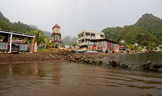
Scotts Head is a village on the southwest coast of Dominica, in Saint Mark Parish. In 2001, its population was 721. Predominantly a fishing village, Scotts Head overlooks Soufrière Bay, which is protected as the Soufrière Scotts Head Marine Reserve. It is also a popular snorkeling and diving site for tourists.

Marigot is the largest settlement of Saint Andrew Parish in northeastern Dominica. The village has a population of 2,676 people, and is home to a Fisheries Complex as well as the island's main airport. It is the birthplace of local politician Edison James, and cricket umpire Billy Doctrove.
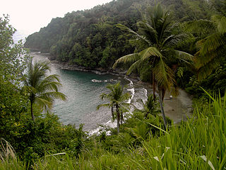
Soufrière is a village on the southwest coast of Dominica. It is the capital of Saint Mark Parish and has a population of 1,416 people.

Saint Joseph is the chief settlement of Dominica's St. Joseph Parish. Its population is 2,029.
Mero is a small town in Saint Joseph Parish, Dominica. It is located in the west of the island, to the north of the mouth of the Layou River. To the north of Mero is Baroui and to the south of Mero is Saint Joseph.
The Soufrière river is a river on the island of Saint Lucia. The French term "Soufrière" is a generic one referring to "Sulphury" volcanic peaks called La Soufrière or Soufrière Hills on each of St. Vincent, St. Lucia, Dominica, Guadeloupe.

Penville or Pennville is a village in Dominica's Saint Andrew Parish. The community is situated just north of Vieille Case, and has a population of 524.

Soufrière is a town on the West Coast of Saint Lucia, in the eastern Caribbean Sea. The town and the surrounding district has a population of 7,935. It was colonized by the French and was the original capital of the island.
Coulibistrie is a village on the west coast of Dominica, in the northwest corner of Saint Joseph Parish. It is between the villages of Colihaut to the north and Morne Rachette to the south. It extends inland from the coast within a deep valley, along both banks of the Coulibistrie River. It is primarily residential with few businesses. Many of the houses are built directly atop or adjoining the numerous large boulders that litter the valley along its base.

Morne Rachette or Morne Raquette is a village on the west coast of Dominica, in the northwest corner of Saint Joseph Parish. It is located on the slopes of Morne Jalousie, above Coulibistrie to its immediate north and Batalie Bay. The village of Salisbury is south of Morne Rachette.
Belles is a small village in the Caribbean island nation of Dominica. It is located at 15°27′12.7″N61°19′11.4″W and is a part of the country's St. Joseph administrative division. Its population is 500. Belles is a historical site for a few reasons. It is a major part of the highway system to the northern part of the island. The roads were blocked many years ago by Rastafarians who were not happy with the government. Many of them escaped to Jaco Flats and used it for refuge. This is a site that was used by the Maroons hundreds of years ago. As of 2016, the Esprit and Benjamin families own and control a majority of the private land.
Layou is a small village on the western coast of Dominica located near the mouth of the Layou River, after which it was named. The dominant trade in the area is fishing, though a few scattered farms are still active.