Morne Bruce

Last updated
View from Morne Bruce, with cannon Morne Bruce Gun (46985608102).jpg
View from Morne Bruce, with cannon

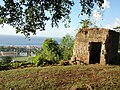
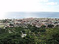
Morne Bruce is a hillside enclave located in Roseau, Dominica. It offers a panoramic view of the city and the Caribbean Sea beyond. [1] The site was once home to the military garrison that protected Roseau. Remains of the original barracks and officers' quarters can still be seen today. [1] One of the old cannons (non-operational) is still located at the site, near a giant cross that was erected in the 1920s. [1] Morne Bruce is accessible by road or via Jack's Walk, a trail that begins in the Dominica Botanical Gardens. [2] [3]

Contents

Etymology

It was named after James Bruce, a captain of the Royal Engineers who designed many of Dominica's forts in the 1700s. [4] [5] [6]

History

The hill was once home to a military garrison that protected Roseau from the 1770s to 1854 from the French. [6] Remains of the original barracks and officersquarters can still be seen today, along with one of the old cannons. [5] A giant cross was erected at the summit of Morne Bruce in the 1920s. [4]

The idea of establishing the Roseau Botanic Gardens near Morne Bruce was conceived in 1889 by the British Crown Government. [7]

See also

Related Research Articles

<span class="mw-page-title-main">Geography of Dominica</span> Geography of the island country of Dominica

Dominica is an island in the Caribbean Sea, located about halfway between the French islands of Guadeloupe and Martinique. Its coordinates are 15 25 N, 61 20 W. It is known as "The Nature Island of the Caribbean" due to its spectacular, lush, and varied flora and fauna, which is protected by an extensive natural park system. It is the fourth largest island in the Eastern Caribbean with a population of people mainly of African descent.

<span class="mw-page-title-main">Roseau</span> Capital of Dominica

Roseau is the capital and largest city of Dominica, with a population of 16,571 as of 2023. It is a small and compact urban settlement, in the Saint George parish and surrounded by the Caribbean Sea, the Roseau River and Morne Bruce. Built on the site of the ancient Island Carib village of Sairi, it is the oldest and most important urban settlement on the island of Dominica.

<span class="mw-page-title-main">Fort George, Ontario</span> Historic site in Ontario, Canada

Fort George was a military fortification in Niagara-on-the-Lake, Ontario, Canada. The fort was used by the British Army, the Canadian militia, and the United States Armed Forces for a brief period. The fort was mostly destroyed during the War of 1812. The site of the fort has been a National Historic Site of Canada since 1921, and features a reconstruction of Fort George.

<span class="mw-page-title-main">Fort York</span> Historic British garrison in Toronto, Canada

Fort York is an early 19th-century military fortification in the Fort York neighbourhood of Toronto, Ontario, Canada. The fort was used to house members of the British and Canadian militaries, and to defend the entrance of the Toronto Harbour. The fort features stone-lined earthwork walls and eight historical buildings within them, including two blockhouses. The fort forms a part of Fort York National Historic Site, a 16.6 ha (41-acre) site that includes the fort, Garrison Common, military cemeteries, and a visitor centre.

<span class="mw-page-title-main">New Fort York</span> Former Canadian military facility

New Fort York, later the Stanley Barracks, is a former British and Canadian military base in Toronto, Ontario, Canada, located on the Lake Ontario shoreline. It was built in 1840–1841 to replace Toronto's original Fort York at the mouth of Garrison Creek as the primary military base for the settlement. Unlike the older fort, many of the new fort buildings were made with limestone instead of wood. A protective wall was planned for the new fort but was never built. The fort was used by the British army until 1870, and the Canadian military subsequently used the fort to train troops for the Second Boer War, World War I and World War II. It also trained one of the first regiments of the North-West Mounted Police. The Canadian military stopped using it after World War II and the fort was demolished in the 1950s. Only the Officers' Quarters building remains on the site.

<span class="mw-page-title-main">Fort San Pedro</span> Bastioned fort in Cebu, Philippines

Fort San Pedro is a military defense structure in Cebu, Philippines, built by the Spanish under the command of Miguel López de Legazpi, first governor of the Captaincy General of the Philippines. It is located in the area now called Plaza Independencia, in the pier area of the city. The original fort was made of wood and built after the arrival of Legazpi and his expedition. In the early 17th century a stone fort was built to repel Muslim raiders. Today's structure dates from 1738 and is the oldest triangular bastion fort in the country. It served as the nucleus of the first Spanish settlement in the Philippines. During the Philippine Revolution at the end of the 19th century, it was attacked and taken by Filipino revolutionaries, who used it as a stronghold.

<span class="mw-page-title-main">Charles Savarin</span> President of Dominica (2013–2023)

Charles Angelo Savarin, DAH is a politician from Dominica who served as President of Dominica from 2013 to 2023. He is a member of the Dominica Labour Party and served for a time as Minister for National Security, Immigration, Labour and the Public Service.

<span class="mw-page-title-main">Fort Canning Hill</span> Park in Singapore

Fort Canning Hill, formerly Government Hill, Singapore Hill and Bukit Larangan, or simply known as Fort Canning, is a prominent hill, about 48 metres (157 ft) high, in the southeast portion of Singapore, within the Central Area that forms Singapore's central business district.

<span class="mw-page-title-main">Roman Catholic Archdiocese of Castries</span> Latin Catholic ecclesiastical jurisdiction in the Caribbean

The Metropolitan Archdiocese of Castries is an archdiocese of the Latin Church of the Catholic Church in the Caribbean. The archdiocese consists of the entirety of the former British dependency of Saint Lucia and is a metropolitan see, the suffragans of the Castries Province being the Dioceses of Roseau, Saint George's in Grenada, St. John's-Basseterre and Kingstown. The archdiocese is a member of the Antilles Episcopal Conference.

<span class="mw-page-title-main">Cabrits National Park</span>

Cabrits National Park is on a peninsula at the north end of the Caribbean island of Dominica, north of Portsmouth. The park protects tropical forest, coral reefs and wetlands. There are hiking trails and an English garrison called Fort Shirley.

<span class="mw-page-title-main">Scotts Head, Dominica</span>

Scotts Head is a village on the southwest coast of Dominica, in Saint Mark Parish. In 2001, its population was 721. Predominantly a fishing village, Scotts Head overlooks Soufrière Bay, which is protected as the Soufrière Scotts Head Marine Reserve. It is also a popular snorkeling and diving site for tourists.

<span class="mw-page-title-main">Dominica</span> Island country in the Caribbean

Dominica officially the Commonwealth of Dominica, is an island country in the Caribbean. The capital, Roseau, is located on the western side of the island. It is geographically situated as part of the Windward Islands chain in the Lesser Antilles archipelago in the Caribbean Sea. Dominica's closest neighbours are two constituent territories of the European Union, the overseas departments of France, Guadeloupe to the northwest and Martinique to the south-southeast. Dominica comprises a land area of 750 km2 (290 sq mi), and the highest point is Morne Diablotins, at 1,447 m (4,747 ft) in elevation. Its population was 71,293 at the 2011 census.

<span class="mw-page-title-main">Fort Napoléon des Saintes</span> Museum and former fort in Guadeloupe

Fort Napoléon is a fortification, located on Terre-de-Haut Island, in the Îles des Saintes, Guadeloupe. Property of the Departmental Council of Guadeloupe, it has been classified as a historical monument since the December 15, 1997.

<span class="mw-page-title-main">Dominica Botanical Gardens</span>

Dominica Botanic Gardens is located on the Caribbean island-nation of Dominica, in the capital of Roseau. Once known as one of the finest botanical gardens in the region, it was severely damaged by Hurricane David in 1979. Following restoration efforts, it remains a focus of cultural life in Roseau, and a center of conservation research on Dominica.

<span class="mw-page-title-main">Fort Young Hotel</span>

Fort Young Hotel is a hotel on the quayside of Roseau, Dominica, in the southern part of the capital next to Garraway Hotel, Dominica Museum, the Roseau Public Library, just south of the Governor's Residence and Roseau Cathedral. Located within the ramparts of the old colonial military Fort Young of 1770s vintage and built in the backdrop of a quay overlooking the Caribbean Sea, the 71-room hotel was established in 1964 and hosts a diving centre.

<span class="mw-page-title-main">Waitukubuli Trail</span>

The Waitukubuli National Trail is a hiking trail spanning the island of Dominica. It is the longest hiking trail in the Caribbean, at 115 miles (185 km) long. Its name comes from the original Kalinago name of the island, Waitukubuli, meaning "tall is her body". The trails’s management falls under Dominica's Forestry Division.

Layou is a small village on the western coast of Dominica located near the mouth of the Layou River, after which it was named. The dominant trade in the area is fishing, though a few scattered farms are still active.

Sir Henry Alfred Alford Nicholls was a physician, disease specialist, horticulturist, zoologist and legislator in, and publicist for Dominica for over 50 years. He published on a wide variety of topics and was awarded a knighthood for his services just before his death.

Fort Young was a major military installation on the Caribbean island of Dominica. It was built by the British in 1770. The fort was named for William Young, the island's first British governor. Today, only ruins remain of the fort, and the site is the location of the Fort Young Hotel.

<span class="mw-page-title-main">Fort Cachacrou</span>

Fort Cachacrou was a historic military fortification and signal station on the island of Dominica. The fort was built by the British in the 1760s in present-day Scotts Head. During the American Revolutionary War, it was the site of the first battle in the French Invasion of Dominica. Remains of Fort Cachacrou include portions of the original walls and a canon. The site is accessible via the Waitukubuli National Trail.

References

  1. 1 2 3 "Visit Morne Bruce on your trip to Roseau or Dominica • Klarna Trips". trips.klarna.com. Retrieved 2023-03-13.
  2. "Jack's Walk | a virtual Dominica" . Retrieved 2024-01-10.
  3. "Walk in Beauty – Dominica Botanical Gardens". Dominica Weekly. 16 June 2010. Retrieved 2024-01-10.
  4. 1 2 "History of Dominica - Review of Morne Bruce, Roseau, Dominica". Tripadvisor. Retrieved 2023-03-13.
  5. 1 2 "Morne Bruce Garrison Historical Marker". www.hmdb.org. Retrieved 2023-03-13.
  6. 1 2 "Morne Bruce Cross Location, Timing & Telephone Contact Detail" . Retrieved 2023-03-13.
  7. "Morne Bruce, Dominica - All You Need To Know BEFORE You Go". www.viator.com. Retrieved 2023-03-13.

15°17′57″N61°22′43″W / 15.29917°N 61.37861°W / 15.29917; -61.37861