Time in Brazil

Last updated • 4 min readFrom Wikipedia, The Free Encyclopedia

Time in Brazil, since 25 April 2019.
Time in Brazil
.mw-parser-output .legend{page-break-inside:avoid;break-inside:avoid-column}.mw-parser-output .legend-color{display:inline-block;min-width:1.25em;height:1.25em;line-height:1.25;margin:1px 0;text-align:center;border:1px solid black;background-color:transparent;color:black}.mw-parser-output .legend-text{}
ACT
Acre Time
UTC-5
(BRT-2)
AMT
Amazon Time
UTC-4
(BRT-1)
BRT
Brasilia Time
UTC-3
(BRT)
FNT
Fernando de Noronha Time
UTC-2
(BRT+1) Time zones of Brazil.svg
Time in Brazil, since 25 April 2019.
Time in Brazil
 ACT Acre Time UTC−5 (BRT–2)
 AMT Amazon Time UTC−4 (BRT−1)
 BRT Brasília Time UTC−3 (BRT)
 FNT Fernando de Noronha Time UTC−2 (BRT+1)

Time in Brazil is calculated using standard time, and the country (including its offshore islands) is divided into four standard time zones: UTC−02:00, UTC−03:00, UTC−04:00 and UTC−05:00. [1]

Contents

Time zones

Fernando de Noronha time (UTC−02:00)

This is the standard time zone only on a few small offshore Atlantic islands. The only such island with a permanent population is Fernando de Noronha, with 3,167 inhabitants (2022 census), 0.0016% of Brazil's population. [2] The other islands (Trindade and Martim Vaz, Rocas Atoll and Saint Peter and Saint Paul Archipelago) either are totally uninhabited or have small seasonally rotating Brazilian Navy garrisons or teams of scientists.

Brasília time (UTC−03:00)

The main time zone of Brazil comprises the states in the South, Southeast and Northeast regions (except the small islands mentioned above), plus the states of Goiás, Tocantins, Pará and Amapá, and the Federal District, which includes the national capital city, Brasília. About 93% of the Brazilian population live in this time zone, which covers about 60% of the country's land area. [2] It includes 26 of the 28 largest metropolitan areas in Brazil.

Amazon time (UTC−04:00)

This time zone is used in the states of Mato Grosso, Mato Grosso do Sul, Rondônia, Roraima, and most of Amazonas. Although this time zone covers about 36% of the land area of Brazil (an area larger than Argentina), only about 6% of the country's population live there (about 12 million people, slightly more than the city of São Paulo). [2] Thus, covering the country's remaining two metropolitan areas (Manaus, Boa Vista).

Until 2008, the areas of the state of Pará west of the Xingu River and north of the Amazon River (aka the northwestern part of the said state) were also part of this time zone; then they joined the rest of the state in observing Brasília time (UTC−03:00). Although other changes to Brazilian time zones enacted at that time have since been reverted (see below), western and northern Pará still remain in UTC−03:00.

Acre time (UTC−05:00)

This time zone was reinstated in late 2013, after having been abolished for over five years. It is used in the far-western tip of the country, which includes the entire state of Acre and the southwestern portion of the state of Amazonas (west of a line connecting the cities of Tabatinga and Porto Acre). [a] These areas cover only about 4% of the Brazilian territory (although that is still about the size of Germany) and have only about 0.5% of the country's population (little more than one million people). [2]

On 24 June 2008, these areas advanced their clocks by an hour, so that they became part of the UTC−04:00 time zone. [7] However, in a non-binding referendum held on 31 October 2010, a slight majority of Acre voters voted in favour of returning the state to UTC−05:00. [8] On 30 October 2013, Brazilian President Dilma Rousseff enacted Law 12876, establishing that the time zone switch would occur on Sunday, 10 November 2013. [9] Since then, the state of Acre and the southwestern part of the state of Amazonas [a] are again 5 hours behind UTC.

Unofficial observance

Unofficially, 32 municipalities in eastern Mato Grosso, [b] located in the Araguaia valley, observe UTC−03:00, Brasília time. [10] [11] [12]

Unofficially, some municipalities in eastern Mato Grosso do Sul, such as Bataguassu, Aparecida do Taboado, Cassilândia and Chapadão do Sul, also observe UTC−03:00, Brasília time. [13] [14]

Daylight saving time

Brazil observed daylight saving time (DST; Portuguese : horário de verão, "summer time") in the years of 1931–1933, 1949–1953, 1963–1968 and 1985–2019. Initially it applied to the whole country, but from 1988 it applied only to part of the country, usually the southern regions, where DST is more useful due to a larger seasonal variation in daylight duration. It typically lasted from October or November to February or March. [15]

The most recent DST rule specified advancing the time by one hour during the period from 00:00 on the first Sunday in November to 00:00 on the third Sunday in February (postponed by one week if the latter fell on carnival), applicable only to the South, Southeast and Central-West regions, [15] which comprise about 65% of the Brazilian population. [2] During DST, Brasília time moved from UTC−03:00 to UTC−02:00; the other states that did not follow DST observed a change of the offset to Brasília time.

Brazil abolished DST in 2019. [15]

IANA time zone database

The IANA time zone database contains 16 zones for Brazil. Columns marked with * are from the file zone.tab of the database.

c.c.*coordinates*TZ*comments*UTC offsetDST
BR −0351−03225 America/Noronha Atlantic islands −02:00 -
BR −0127−04829 America/Belem Pará (east), Amapá −03:00 -
BR −0343−03830 America/Fortaleza Brazil (northeast: MA, PI, CE, RN, PB) −03:00 -
BR −0803−03454 America/Recife Pernambuco −03:00 -
BR −0712−04812 America/Araguaina Tocantins −03:00 -
BR −0940−03543 America/Maceio Alagoas, Sergipe −03:00 -
BR −1259−03831 America/Bahia Bahia −03:00 -
BR −2332−04637 America/Sao_Paulo Brazil (southeast: GO, DF, MG, ES, RJ, SP, PR, SC, RS) −03:00 -
BR −2027−05437 America/Campo_Grande Mato Grosso do Sul −04:00 -
BR −1535−05605 America/Cuiaba Mato Grosso −04:00 -
BR −0226−05452 America/Santarem Pará (west) −03:00 -
BR −0846−06354 America/Porto_Velho Rondônia −04:00 -
BR +0249−06040 America/Boa_Vista Roraima −04:00 -
BR −0308−06001 America/Manaus Amazonas (east) −04:00 -
BR −0640−06952 America/Eirunepe Amazonas (west) −05:00 -
BR −0958−06748 America/Rio_Branco Acre −05:00 -

See also

Notes

  1. 1 2 The municipalities of Atalaia do Norte, Eirunepé, Envira, Guajará and Ipixuna are located entirely west of the line. Part of the municipalities of Benjamin Constant and Tabatinga, including their seats and most of their population, are also located west of the line. Part of the municipalities of Boca do Acre, Itamarati, Jutaí, Pauini and São Paulo de Olivença are located west of the line, but their seats and almost their entire population are located east of it. [3] Amaturá and Lábrea are sometimes cited as municipalities in UTC−05:00, [4] [5] but they are located entirely east of the line. The seat of Lábrea uses UTC−04:00. [6]
  2. Água Boa, Alto Araguaia, Alto Boa Vista, Alto Taquari, Araguaiana, Araguainha, Barra do Garças, Bom Jesus do Araguaia, Campinápolis, Canabrava do Norte, Canarana, Cocalinho, Confresa, General Carneiro, Luciara, Nova Nazaré, Nova Xavantina, Novo Santo Antônio, Novo São Joaquim, Pontal do Araguaia, Ponte Branca, Porto Alegre do Norte, Querência, Ribeirão Cascalheira, Ribeirãozinho, Santa Cruz do Xingu, Santa Terezinha, São Félix do Araguaia, São José do Xingu, Serra Nova Dourada, Torixoréu and Vila Rica.

Related Research Articles

<span class="mw-page-title-main">Geography of Brazil</span>

The country of Brazil occupies roughly half of South America, bordering the Atlantic Ocean. Brazil covers a total area of 8,514,215 km2 (3,287,357 sq mi) which includes 8,456,510 km2 (3,265,080 sq mi) of land and 55,455 km2 (21,411 sq mi) of water. The highest point in Brazil is Pico da Neblina at 2,994 m (9,823 ft). Brazil is bordered by the countries of Argentina, Bolivia, Colombia, Guyana, Paraguay, Peru, Suriname, Uruguay, Venezuela, and French Guiana.

<span class="mw-page-title-main">Federative units of Brazil</span> Subnational administrative units of Brazil

The federative units of Brazil are subnational entities with a certain degree of autonomy and endowed with their own government and constitution, which together form the Federative Republic of Brazil. There are 26 states and one federal district. The states are generally based on historical, conventional borders which have developed over time. The states are divided into municipalities, while the Federal District assumes the competences of both a state and a municipality.

<span class="mw-page-title-main">Amazonas (Brazilian state)</span> State of Brazil

Amazonas is a state of Brazil, located in the North Region in the north-western corner of the country. It is the largest Brazilian state by area and the ninth-largest country subdivision in the world. It is the largest country subdivision in South America, being greater than the areas of Chile, Paraguay, and Uruguay combined. Neighbouring states are Roraima, Pará, Mato Grosso, Rondônia, and Acre. It also borders the nations of Peru, Colombia and Venezuela. This includes the Departments of Amazonas, Vaupés and Guainía in Colombia, as well as the Amazonas state in Venezuela, and the Loreto Region in Peru.

<span class="mw-page-title-main">Mato Grosso</span> State of Brazil

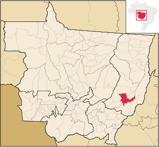
Mato Grosso is one of the states of Brazil, the third largest by area, located in the Central-West region. The state has 1.66% of the Brazilian population and is responsible for 1.9% of the Brazilian GDP.

<span class="mw-page-title-main">Central-West Region, Brazil</span> Region in Brazil

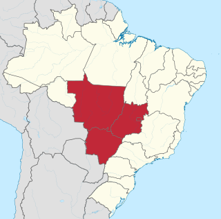
The Central-West or Center-West Region of Brazil is composed of the states of Goiás, Mato Grosso and Mato Grosso do Sul; along with Distrito Federal, where Brazil's national capital, Brasília, is situated. The region comprises 18.86% of the national territory, and is the least populated in Brazil.

São Félix can refer to the following places:

<span class="mw-page-title-main">Araguaia River</span> River in Pará, Brazil

The Araguaia River is one of the major rivers of Brazil, and a tributary of the Tocantins River.

<span class="mw-page-title-main">UTC−03:00</span> Identifier for a time offset from UTC of −3

UTC−03:00 is an identifier for a time offset from UTC of −03:00.

The Xingu Indigenous Park is an indigenous territory of Brazil, first created in 1961 as a national park in the state of Mato Grosso, Brazil. Its official purposes are to protect the environment and the several nations of Xingu Indigenous peoples in the area.

The Trumai are an indigenous people of Brazil. They currently reside within the Xingu Indigenous Park, in the state of Mato Grosso. They have a population of 258 in 2014. They were 97 in 2011 and 120 in 2006, up from a low of 26 in 1966.

<span class="mw-page-title-main">Outline of Brazil</span> Country in South America

The following outline is provided as an overview of and topical guide to Brazil:

<span class="mw-page-title-main">Nova Xavantina</span> Municipality in Center-West, Brazil

Nova Xavantina is a municipality in the state of Mato Grosso in the Central-West Region of Brazil.

<span class="mw-page-title-main">Juruena National Park</span> National park in Brazil

Juruena National Park, declared in 2006, is the third largest national park of Brazil. It is located along the Juruena River, in the north of Mato Grosso state and the south of Amazonas state. It forms part of a corridor of protected areas that is meant to contain agricultural expansion into the Amazon rainforest.

Daylight saving time in the Americas is the arrangement in the Americas by which clocks are advanced by one hour in spring and moved back in autumn, to make the most of seasonal daylight. The practice is widespread in North America, with most of Canada and the United States participating, but much less so in Central and South America.

<span class="mw-page-title-main">Time in Portugal</span>

Portugal has two time zones and observes daylight saving time. Continental Portugal and Madeira use UTC+00:00, while the Azores use UTC–01:00. Daylight saving time is observed nationwide from the last Sunday in March to the last Sunday in October, when continental Portugal and Madeira advance one hour to UTC+01:00, and the Azores advances one hour to UTC+00:00.

The Rio Roosevelt Ecological Station is an ecological station in the state of Mato Grosso, Brazil.

<span class="mw-page-title-main">Mato Grosso tropical dry forests</span> Ecoregion in central Brazil

The Mato Grosso tropical dry forests (NT0140), also called the Mato Grosso seasonal forests, is an ecoregion in central Brazil to the south of the Amazon region. It contains vegetation in the transition between the Amazon rainforest to the north and the cerrado savanna to the south. The opening of highways through the region has caused rapid population growth, deforestation and pollution.

<span class="mw-page-title-main">2010 Acre time zone referendum</span>

The 2010 Acre referendum consisted of a decision regarding maintaining the time zone change for the Brazilian state of Acre, as the state had an 1-hour difference from Brasília Time (UTC-03:00) in 2008, when the original time zone had minus 2 hours from Brasília.

General elections will be held in Brazil on 4 October 2026 to elect the president, vice president, members of the National Congress, the governors, vice governors, and legislative assemblies of all federative units, and the district council of Fernando de Noronha. If no candidate for president or governor receives a majority of the valid votes in the first round, a runoff election is held on 25 October.

Proposals for the creation of federative units in Brazil are currently under discussion and in different stages of processing in the National Congress. The creation of 18 new states and three new federal territories were officially proposed, which would bring the total number of federative units to 48. The region with the largest number of federative units would be the North region, while the South region would be the only one with a new federative unit. The states with the most advanced stage of creation are Gurgueia and Maranhão do Sul both in the Northeast region.

References

  1. Decree no. 2784, of 18 June 1913, Presidency of Brazil. (in Portuguese)
  2. 1 2 3 4 5 "Tabela 4714 – população residente, área territorial e densidade demográfica" [Table 4714 – resident population, territorial area and population density] (in Portuguese). Brazilian Institute of Geography and Statistics. 2022.
  3. "Mapa dos locais de votação" [Map of voting locations] (in Portuguese). Regional Electoral Court of Amazonas. 9 August 2022.
  4. "Votação em todo o país seguirá o horário de Brasília (DF)" [Voting in the whole country will follow Brasília time] (in Portuguese). Superior Electoral Court. 30 October 2022.
  5. "Candidados do Amazonas devem ficar atentos ao fuso horário" [Applicants from Amazonas should be mindful of the time zone] (in Portuguese). Ministry of Education of Brazil. 31 October 2018.
  6. "Pregão eletrônico nº 9/2022" [Electronic auction no. 9/2022] (in Portuguese). Federal Institute of Amazonas. 25 July 2022.
  7. "Brazil Abolishes Its Fourth Time Zone in 2008" . Retrieved 2008-06-25.
  8. "Time Zone Change is Possible in Acre, Brazil".
  9. Subdirectorate for Legal Affairs. "Lei nº 12.876, de 30 de outubro de 2013" [Law no. 12,876 of 30 October 2013] (in Portuguese). The Presidency of the Federative Republic of Brazil. Retrieved 11 September 2020.
  10. "No clock change for parts of Mato Grosso, Brazil". Timeanddate.com. 25 October 2011.
  11. "Municípios do Araguaia trocam horário de Brasília por de MT durante horário de verão" [Araguaia municipalities swap Brasilia time for that of Mato Grosso during summer time] (in Portuguese). Olhar Direto. 19 October 2013.
  12. "Começa horário de verão e Araguaia passa a seguir horário de MT" [Summer time begins and Araguaia starts following Mato Grosso time] (in Portuguese). Água Boa News. 10 October 2015.
  13. "Por intermédio de Eduardo Rocha, técnico da Energisa irá falar sobre o fornecimento de Bataguassu" [By mediation of Eduardo Rocha, an Energisa technician will talk about the supply of Bataguassu] (in Portuguese). Jornal do Estado. 24 November 2017.
  14. "Um estado, 'dois' fusos: cidades de MS geram confusão e curiosidade por diferenças no horário" [One state, 'two' time zones: cities of MS generate confusion and curiosity due to differences in time] (in Portuguese). G1. 27 December 2023.
  15. 1 2 3 "Decrees on daylight saving time in Brazil" (in Portuguese). National Observatory of Brazil . Retrieved 2019-11-25.