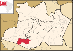
Pauini | |
---|---|
Coordinates: 7°42′50″S66°58′33″W / 7.71389°S 66.97583°W | |
Country | Brazil |
Region | North |
State | Amazonas |
Area | |
• Total | 43,263 km2 (16,704 sq mi) |
Population (2020) | |
• Total | 19,522 |
• Density | 0.45/km2 (1.2/sq mi) |
Time zone | UTC−4 (AMT) |
Pauini is a municipality located in the Brazilian state of Amazonas.
The population of Pauini was 19,522 in 2020. [1] Its area is 43,263 square kilometres (16,704 sq mi). [2] The municipality contains the 256,000 hectares (630,000 acres) Purus National Forest, created in 1988. [3] It holds 8% of the 311,000 hectares (770,000 acres) Mapiá-Inauini National Forest, created in 1989. [4] It also contains 8% of the 604,209 hectares (1,493,030 acres) Médio Purus Extractive Reserve, created in 2008. [5]
The Purus River is a tributary of the Amazon River in South America. Its drainage basin is 371,042 km2 (143,260 sq mi), and the mean annual discharge is 11,207 m3/s (395,800 cu ft/s). The river shares its name with the Alto Purús National Park and the Purús Province, one of the four provinces of Peru in the Ucayali Region.
Lábrea is the southernmost municipality in the Brazilian state of Amazonas.
Feijó is a municipality located in the center of the Brazilian state of Acre. As of 2020, its population was 34,884. The total land area is 24,202 km².
Sena Madureira is a municipality located in the center of the Brazilian state of Acre. Its population is 46,511 and its area is 25,278 square kilometres (9,760 sq mi), making it the largest municipality in the state. It has a climate which combines temperatures of 78 °F (26 °C) with humidities in the upper 90s percent, all year round. It is 143 km from Rio Branco. The oldest church in Acre state is located in Sena Madureira, the Nossa Senhora da Imaculada Conceição Church (1910).
Apuí is a municipality located in the Brazilian state of Amazonas. Its population was 22,359 (2020) and its area is 54,240 km2.
Beruri is a municipality located in the Brazilian state of Amazonas. Its population was 20,093 (2020) and its area is 17,251 km².
Boca do Acre is a municipality located in the Brazilian state of Amazonas. Its population was 34,635 (2020) and its area is 22,349 km2.
Canutama is a municipality located in the Brazilian state of Amazonas, considered third largest city of the Purus Medium after Lábrea and Tapauá.
Carauari is a municipality located in the Brazilian state of Amazonas. Its population was 28,508 (2020) and its area is 25,767 km².
Juruá is a municipality located in the Brazilian state of Amazonas. Its population was 15,106 (2020) and its area is 19,400 km².
Novo Aripuanã is a municipality located in the Brazilian state of Amazonas.
Tapauá is a municipality located in the Brazilian state of Amazonas. Its population was 17,015 (2020) and its area is 89,324 km2, making it the third largest municipality in Amazonas and the fifth largest in Brazil, comparable to South Carolina or Jordan.
Alenquer is a municipality in the state of Pará in the Northern region of Brazil. The town is located on the northern bank of the Amazon River, roughly across from the city of Santarém.
Parauapebas is a municipality in the state of Pará in the Northern region of Brazil.
São Félix do Xingu is a municipality in the state of Pará in the Northern region of Brazil.
Nascentes do Lago Jari National Park is a national park in the state of Amazonas, Brazil. It protects an area of Amazon rainforest in the BR-319 highway area of influence.
The Balata-Tufari National Forest is a national forest in the state of Amazonas, Brazil. It was created to support sustainable extraction of forest products such as timber subject to restrictions and regulations defined by law or the responsible agency, ICMBio.
The Médio Purus Extractive Reserve is an extractive reserve in the state of Amazonas, Brazil.
The Purus National Forest is a national forest in the state of Amazonas, Brazil. It surrounds the shamanic-Christian community of Céu do Mapiá.
The Mapiá-Inauini National Forest is a national forest in the state of Amazonas, Brazil.