Iranduba

Last updated
Iranduba
Municipality
Municipality of Iranduba
Iranduba.JPG
Iranduba near Solimões River
Bandeira de Iranduba.jpg
Iranduba Coat.jpg
Nickname: 
"Cidade das Chaminés" ("City of Chimneys")
Iranduba.svg
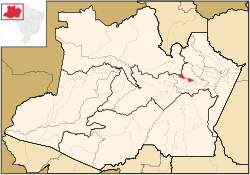
Location of Jutaí in the State of Amazonas
Coordinates: 03°17′06″S60°11′09″W / 3.28500°S 60.18583°W / -3.28500; -60.18583
Country Flag of Brazil.svg  Brazil
Region North
State Bandeira do Amazonas.svg Amazonas
Emancipated1981
Government
   Mayor Raymundo Nonato (PMDB)
Area
  Total2,215.033 km2 (855.229 sq mi)
Elevation
92 m (302 ft)
Population
 (2020)
  Total49,011
  Density18.94/km2 (49.1/sq mi)
  [1]
Time zone UTC−4 (AMT)
Area code +55 92
HDI (2000)0.694 – medium [2]
Website www.iranduba.am.gov.br

Iranduba is a municipality located in the Brazilian state of Amazonas.

The population of Iranduba in 2020 was 49,011 and its area is 2,215 km2, [3] making it the smallest municipality in Amazonas in terms of area.

Geography

The municiaplity is located south and west of Manaus on the right bank of the Rio Negro and the left bank of the Solimões River. It is connected to Manaus by the Manaus Iranduba Bridge, a cable-stayed bridge which opened in 2011.

The municipality contains about 21% of the Rio Negro Right Bank Environmental Protection Area, a 1,140,990 hectares (2,819,400 acres) sustainable use conservation unit that controls use of an area of Amazon rainforest along the Rio Negro above the junction with the Solimões River. [4] It also contains about 80% of the Rio Negro Sustainable Development Reserve, a 103,086 hectares (254,730 acres) sustainable use conservation unit created in 2008 in an effort to stop deforestation in the area, which is threatened due to its proximity to Manaus. [5]

Related Research Articles

<span class="mw-page-title-main">Jaú National Park</span> National park in Brazil

The Jaú National Park is a national park located in the state of Amazonas, Brazil. It is one of the largest forest reserves in South America, and part of a World Heritage Site.

<span class="mw-page-title-main">Tefé</span> Municipality in North, Brazil

Tefé, known in early accounts as Teffé, is a municipality in the state of Amazonas, northern Brazil.

<span class="mw-page-title-main">Manacapuru</span> Municipality in North, Brazil

Manacapuru (Munychapur) is a municipality located in the Brazilian state of Amazonas.

<span class="mw-page-title-main">Barcelos, Amazonas</span> Municipality in North, Brazil

Barcelos, formerly Mariuá, is a municipality located in the State of Amazonas, northern Brazil. Its population was 27,638 (2020) and its area is 122,476 square kilometres (47,288 sq mi), making it the second largest municipality in Brazil, equivalent in size to New York state in the United States and slightly larger than North Korea.

<span class="mw-page-title-main">Borba, Amazonas</span> Municipality in North, Brazil

Borba is a municipality in the state of Amazonas in northern Brazil.

<span class="mw-page-title-main">Itapiranga, Amazonas</span> Municipality in North, Brazil

Itapiranga is a municipality located in the state of Amazonas northern Brazil on the left bank of the Solimões River about 200 km east of Manaus. Its population was 9,230 (2020) and its area is 4,231 km2.

<span class="mw-page-title-main">Jutaí</span> Municipality in North, Brazil

Jutaí is a municipality located in the Brazilian state of Amazonas. Its population is 13,886 (2020) and its area is 69,552 km2, making it the fifth largest municipality in Amazonas by area and the ninth largest in Brazil.

<span class="mw-page-title-main">Novo Aripuanã</span> Municipality in North, Brazil

Novo Aripuanã is a municipality located in the Brazilian state of Amazonas.

<span class="mw-page-title-main">Presidente Figueiredo</span> Municipality in North, Brazil

Presidente Figueiredo is a municipality located in the Brazilian state of Amazonas. Its population was 37,193 (2020) and its area is 25,422 km2.

<span class="mw-page-title-main">Novo Airão</span> Municipality in the state of Amazonas, Brazil

Novo Airão is a municipality located in the state of Amazonas in northern Brazil on the Rio Negro River about 180 km upstream of Manaus. Its population was 19,928 (2020) and its area is 37,771 km2. The town is accessible by both river and road.

<span class="mw-page-title-main">Anavilhanas National Park</span> National park in Brazil

Anavilhanas National Park is a national park that encompasses a huge river archipelago in the Rio Negro in the state of Amazonas, Brazil. It is part of a World Heritage Site.

Amanã Sustainable Development Reserve is a sustainable development reserve in the state of Amazonas, Brazil.

<span class="mw-page-title-main">Cuieiras River (Rio Negro tributary)</span> River in Brazil

The Cuieiras River is a river in the municipality of Maués, Amazonas state, Brazil.

Rio Negro State Park South Section is a State park in the state of Amazonas, Brazil. It protects an area of Amazon rainforest to the east of the Rio Negro that is home to the endangered pied tamarin. The area was reduced in 2001 and was further reduced in 2014 to create a sustainable development reserve for the people that had been living there since before the park was created.

The Rio Negro State Park North Section is a state park in the state of Amazonas, Brazil. It protects an area of Amazon rainforest to the west of the Rio Negro.

The Rio Negro Right Bank Environmental Protection Area is an Environmental protection area (APA) in the state of Amazonas, Brazil.

The Rio Negro Sustainable Development Reserve is a sustainable development reserve (RDS) in the state of Amazonas, Brazil.

<span class="mw-page-title-main">Rio Negro Left Bank Environmental Protection Area</span> Environmental protection area in Amazonas, Brazil

The Rio Negro Left Bank Environmental Protection Area is an environmental protection area in the state of Amazonas, Brazil. It protects an area of Amazon rainforest on the left bank of the Rio Negro near Manaus. There is a small human population, and sustainable use of forest resources is allowed. The southern section, near to Manaus, is subject to pressure from poor residents of an official settlement project who clear forest to make charcoal for sale in the city.

Puranga Conquista Sustainable Development Reserve is a sustainable development reserve (RDS) in the state of Amazonas, Brazil. It protects an area of Amazon rainforest on the left bank of the Rio Negro near Manaus. The reserve was carved out of the Rio Negro State Park South Section after a lengthy struggle by the occupants of the area who had lived there for years before the state park was created.

<span class="mw-page-title-main">Lower Rio Negro Mosaic</span>

The Lower Rio Negro Mosaic (Portuguese: Mosaico do Baixo Rio Negro is a protected area mosaic in the state of Amazonas, Brazil. It coordinates between eleven conservation units of different types in the Amazon rainforest to the northwest of the state capital, Manaus.

References

  1. IBGE 2020
  2. Archived 2009-10-03 at the Wayback Machine - UNDP
  3. IBGE - "Archived copy". Archived from the original on 2007-01-09. Retrieved 2014-08-03.{{cite web}}: CS1 maint: archived copy as title (link)
  4. APA Margem Direita do Rio Negro (in Portuguese), ISA: Instituto Socioambiental, retrieved 2016-06-26
  5. RDS do Rio Negro (in Portuguese), ISA: Instituto Socioambiental, retrieved 2016-06-27