Recife is the fourth-largest urban area in Brazil with 4,054,866 inhabitants, the largest urban area of the North/Northeast Regions, and the capital and largest city of the state of Pernambuco in the northeast corner of South America. The city has more than a thousand shootings per year, making it one of the most violent in Brazil.The population of the city proper was 1,653,461 in 2020. Recife was founded in 1537, during the early Portuguese colonization of Brazil, as the main harbor of the Captaincy of Pernambuco, known for its large scale production of sugar cane. It was the former capital Mauritsstad of the 17th century colony of New Holland of Dutch Brazil, established by the Dutch West India Company. The city is located at the confluence of the Beberibe and Capibaribe rivers before they flow into the South Atlantic Ocean. It is a major port on the Atlantic. Its name is an allusion to the stone reefs that are present by the city's shores. The many rivers, small islands and over 50 bridges found in Recife city centre characterise its geography and led to the city being called the "Brazilian Venice". As of 2010, it is the capital city with the highest HDI in Northeast Brazil and second highest HDI in the entire North and Northeast Brazil.

Rio de Janeiro is one of the 27 federative units of Brazil. It has the second largest economy of Brazil, with the largest being that of the state of São Paulo. The state, which has 8.2% of the Brazilian population, is responsible for 9.2% of the Brazilian GDP.

Pernambuco is a state of Brazil, located in the Northeast region of the country. With an estimated population of 9 million people as of 2022, making it seventh-most populous state of Brazil and with around 98,067.877 km2, being the 19th-largest in area among federative units of the country, it is the sixth-most densely populated with around 89 people per km2. Its capital and largest city, Recife, is one of the most important economic and urban hubs in the country. Based on 2019 estimates, the Recife Metropolitan Region is seventh-most populous in the country, and the second-largest in northeastern Brazil. In 2015, the state had 4.4% of the national population and produced 2.8% of the national gross domestic product (GDP).

Caruaru is a Brazilian municipality in the state of Pernambuco. The most populous city in the interior of the state, Caruaru is located in the microzone of Agreste and because of its cultural importance, it is nicknamed Capital do Agreste, Princesinha do Agreste, and Capital do Forró.
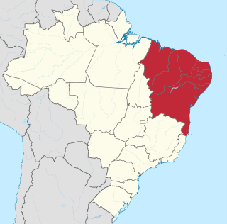
The Northeast Region of Brazil is one of the five official and political regions of the country according to the Brazilian Institute of Geography and Statistics. Of Brazil's twenty-six states, it comprises nine: Maranhão, Piauí, Ceará, Rio Grande do Norte, Paraíba, Pernambuco, Alagoas, Sergipe and Bahia, along with the Fernando de Noronha archipelago.
Cabo de Santo Agostinho is a 448 square kilometer sized municipality located 35 kilometers south of the city of Recife, Pernambuco, Brazil. It is believed by some historians that Vicente Yáñez Pinzón had set anchor in a bay in Cabo de Santo Agostinho on January 26, 1500, however the Portuguese discovery of Brazil was by Pedro Álvares Cabral on April 21, 1500 is officially recognized instead. Cabo de Santo Agostinho was incorporated as a town in 1811.

Jaboatão dos Guararapes is a city in the state of Pernambuco, Brazil. It is a part of the Recife metro area. The population was 706,867 according to the Brazilian Institute of Geography and Statistics (IBGE) in 2020, making it the second most-populous city in the state of Pernambuco and the 27th in Brazil, ahead of major Brazilian state capitals such as Cuiabá and Aracaju. The city is a very important industrial center, hosting companies like Unilever and Coca-Cola. It is bordered by Recife in the north, Cabo de Santo Agostinho on the south, and Mangue forests to the west in Moreno.

Gravatá is a city in the state of Pernambuco, Brazil, located about 75 km (47 mi) from the state's capital Recife. The population of Gravatá in 2022 was 86.516 inhabitants, according with IBGE.

Boa Viagem is a neighborhood in Recife, Pernambuco in the wealthy southern zone of the municipality. The neighborhood has one of the most visited beaches in Northeastern Brazil, Boa Viagem beach. The neighborhood has a population as of 2010 of 122,922 inhabitants, and an area of 753 hectares (2.91 sq mi).

Vitória de Santo Antão is a city in Pernambuco State, Brazil, 46 kilometers west of Recife. Its territorial area is 335,942 km², 5,717 km² of which lies within the urban perimeter. In 2021, the Brazilian Institute of Geography and Statistics (IBGE) estimated its population at approximately 140 389 inhabitants, being the tenth most populous city in Pernambuco, the fourth most populous in the interior of the state and the most populous in Zona da Mata. According to the Firjan Municipal Development Index (IFDM), Vitória de Santo Antão was elected the 8th best city of Pernambuco to live in.

Ipojuca is a municipality in Pernambuco in eastern Brazil. As of 2020 the population according to IBGE was 97,669 and the per capita income (2007) was R$76.418 making it one of the country's highest. The settlement dates to 1560, but the official founding date is 1861 and the community was incorporated as a town in 1864. It is famous for its beaches such as Porto de Galinhas, Muro Alto, Maracaipe.

Sirinhaém is a municipality in Pernambuco with 46,361 inhabitants. The town was founded in 1614 making it among the oldest in the state. The Mayor is Camila Machado Leocadio Lins Dos Santos.

Recife Metropolitan Area, officially the Metropolitan Region of Recife, is a major metropolitan area in Northeast Brazil with a population of 4.02 million as of 2020, centered on the state capital of Recife, Pernambuco. In 2017, it was ranked as the 8th largest Metropolitan Region nationally.
Moreno is a city in the state of Pernambuco, Brazil. It's integrated in the Recife metropolitan area with another 13 cities. Moreno has a total area of 195.6 square kilometers and had an estimated population of 63,294 inhabitants in 2020 according with IBGE.

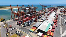
Recife Port is located in Recife Antigo in the city of Recife. This international port serves the RMR and has two main operational areas: cruises and cargo. It is located on the eastern island of Recife antigo on the banks of rivers Capibaribe and Beberibe. Differentiates itself from another ports located in the city center the fact that the port does not have any interferences with the center. Its administered by the Government of the state of Pernambuco and is historically deeply linked with the arrive of the first settlers in Recife (1537).

Escada is a city in northeastern Brazil, in the State of Pernambuco, with 59 836 inhabitants according with IBGE 2022. It is the most populous municipality in its microregion and one of the main ones in the Microregion of the Southern Forest of Pernambuco. It is located at a distance of 60 km from the capital of Pernambuco, Recife. Known as "Princesa dos Canaviais", a nickname that refers to the large plantations and sugar cane mills installed in the region.

Primavera is a city located in the state of Pernambuco, Brazil. Located at 81.6 km away from Recife, capital of the state of Pernambuco. It has an estimated population of 15,101 inhabitants. Its name means spring in Portuguese.
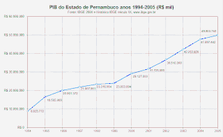
The economy of the Brazilian state of Pernambuco is based on agriculture, animal husbandry and industries. The economy of the state, after stagnating from 1985 and 1995, has been growing rapidly since the end of the twentieth century. In 2000, the GDP per capita was R$3.673 ($2098), resulting in more than 40% growth in this period, and more than 10% in a year. In 2007, the GDP per capita grew up to R$7.337 ($4.217).

Ricardo Coimbra de Almeida Brennand was a Brazilian businessman, engineer, and art collector in the state of Pernambuco. In 2002 he founded the Ricardo Brennand Institute, which includes the world's largest private collection of Frans Post paintings, and was the 17th-highest-rated museum in the world according to TripAdvisor in 2014.

Estaleiro Atlântico Sul (EAS) is a Brazilian shipbuilding company. Estaleiro Atlântico was founded in 2005 by Brazilian construction groups Grupo Camargo Corrêa and Grupo Queiroz Galvão in response to growing demand in the shipbuilding market in Brazil. Samsung in South Korea supplied the shipbuilding technology. The shipyard facility is located in the deep water port of Suape, in the state of Pernambuco, and is situated between the municipalities of Ipojuca and Cabo de Santo Agostinho, at the mouth of the Ipojuca River, about 40 km from the major city of Recife. The dry dock, with two, 1500 ton wing gates has a length of 400 meters, is 73 meters wide and had a water depth of 12 meters.