
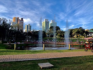
Porto Alegre is the capital and largest city of the Brazilian state of Rio Grande do Sul. Its population of 1,488,252 inhabitants (2020) makes it the 12th-most populous city in the country and the center of Brazil's fifth-largest metropolitan area, with 4,405,760 inhabitants (2010). The city is the southernmost capital city of a Brazilian state.

Rio Grande do Sul is a state in the southern region of Brazil. It is the fifth-most-populous state and the ninth largest by area. Located in the southernmost part of the country, Rio Grande do Sul is bordered clockwise by Santa Catarina to the north and northeast, the Atlantic Ocean to the east, the Uruguayan departments of Rocha, Treinta y Tres, Cerro Largo, Rivera and Artigas to the south and southwest, and the Argentine provinces of Corrientes and Misiones to the west and northwest. The capital and largest city is Porto Alegre. The state has the highest life expectancy in Brazil, and the crime rate is relatively low compared to the Brazilian national average. Despite the high standard of living, unemployment is still high in the state, as of 2017. The state has 5.4% of the Brazilian population and it is responsible for 6.6% of the Brazilian GDP.

Uruguaiana is a municipality in the Brazilian state of Rio Grande do Sul. It is located on the eastern shore of the Uruguay River bordering Argentina. Opposite to Uruguaiana, and joined to it by a road/railway bridge, lies the Argentine city of Paso de los Libres, Corrientes. North of Uruguaiana lies the Brazilian municipality of Itaqui, connected by a bridge constructed by the British in 1888 over the Ibicuí River. The municipality also borders the municipalities of Alegrete, Barra do Quaraí and Quaraí, and, also, Uruguay, making it one of the few international triple-border municipalities of Brazil.

The Brazilian Highway System is a network of trunk roads administered by the Ministry of Transport of Brazil. It is constructed, managed and maintained by the National Department of Transport Infrastructure (DNIT), federal agency linked to the Ministry of Infrastructure, and the public works departments of state governments.

Santa Maria is a municipality (município) in the central region of Rio Grande do Sul, the southernmost state of Brazil. In 2020, its population was 283,677 inhabitants in a total area of 1,823 square kilometres (704 sq mi). Santa Maria is the 5th biggest municipality in the state, and the largest in its micro-region.

The Campeonato Gaúcho, officially named as Campeonato Gaúcho de Futebol Série A and commonly known as the Gauchão or the Gauchão Ipiranga for sponsorship reasons, is the state football league of the Brazilian state of Rio Grande do Sul. It has been contested since its founding in 1919, being an amateur competition until 1940 when the league became professional. Twelve teams contest in the Campeonato Gaúcho, typically from January to April, for the state championship title.
Passo Fundo is a municipality in the north of the southern Brazilian state of Rio Grande do Sul. It is named after its river. It's the twelfth largest city in the state with an estimated population of 204,722 inhabitants living in a total municipal area of 780 km2.

Bagé is a Brazilian municipality located in the state of Rio Grande do Sul. In 2020, its population was 121,335 in a total area of 4,096 km2. It is the seventeenth largest city in the state according to the 2011 census. The city was founded in 1811 and given city status in 1859. Due to its strategic border location, Bagé has remained of significant military importance. Prior to official reorganization as a city, Bagé was seized by military forces from Uruguay and Argentina.
Gravataí is a Brazilian municipality near Porto Alegre at the Rio Grande do Sul State. Its population is approximately 280,000 people, making it the sixth most populous city in the state.

Itaqui is a municipality in Brazil, located in the southwestern part of the state of Rio Grande do Sul, close to the Argentinian border, between Uruguaiana and São Borja. It sits at a mean altitude of 57 meters (187 ft), by the Uruguay River. Its population is currently estimated at 37,489.
Sport Club Rio Grande is a professional association football club based in Rio Grande, Rio Grande do Sul, Brazil. Founded in July 1900, they are Brazil's oldest active football club.
Carazinho is a city located 246 km from Porto Alegre, in the northwest portion of the Brazilian state of Rio Grande do Sul. Carazinho was founded on 1931 and as of 2020 has a population of 62,265. Carazinho's primary economy is focused on agriculture. Soybeans, corn and wheat are the major products.

Rosário do Sul is a Brazilian municipality in the southwestern part of the state of Rio Grande do Sul. The population is 39,314 in an area of 4,369.65 km². Its elevation is 151 m. It is located 385 km west of the state capital of Porto Alegre. Its main industry is agriculture. Many Argentine and Uruguayan tourists visits during the spring, with a large infrastructure to accommodate the visitors.

The Economy of Porto Alegre is the fastest growing economy in Brazil and is currently the country's 7th largest regional economy. The city of Porto Alegre has a population of approximately 1.4 million people. The history of Porto Alegre, particularly during the industrial revolution established its economy and the basis of the current industrial sector in the city.

Esporte Clube Cruzeiro, commonly referred to as Cruzeiro-RS, is a Brazilian football club based in Cachoeirinha, Rio Grande do Sul. It currently plays in Campeonato Gaúcho Série A2, the second level of the Rio Grande do Sul state football league.

The BR-290 is an important highway in the Rio Grande do Sul state of Brazil. Approximately 726km long, the highway runs from the port city of Osório westward to the city of Uruguaiana, on the border of Argentina.

The BR-293 is an east-west highway in the state of Rio Grande do Sul, Brazil. The highway connects Pelotas to Quaraí, crossing important cities in the southern tip of Brazil such as Bagé and Santana do Livramento. The highway measures 535.7 km.

The Port of Paranaguá is one of the main ports of Brazil and Latin America. It's located in the city of Paranaguá, in the Brazilian state of Paraná. It's the second largest port of Brazil in tonnage and the third in container shipping. It's a main exporting port of agricultural products in Brazil, especially soybeans and soybean meal.
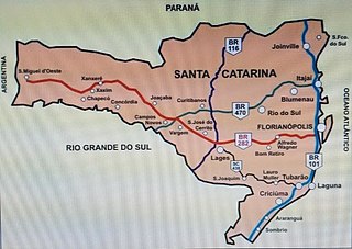
BR-470 is an east-west Brazilian federal highway that starts in Navegantes, Santa Catarina, and crosses the Gaucho range and highlands. It stretches approximately 833 km, passing through cities such as Itajaí, Blumenau, Rio do Sul, Curitibanos, Campos Novos, Bento Gonçalves, Veranópolis and Montenegro and ends in Camaquã, Rio Grande do Sul.

The Port of Itajaí is one of the main ports of Brazil and Latin America. It's located on the Itajaí-Açu river in the city of Itajaí, in the Brazilian state of Santa Catarina. In container handling, it's the 2nd largest port in Brazil; leads the ranking among exporters of frozen products. In imports, the main products are machinery, engines and equipment.


